We are now at the last stopover of our journey, and with it at the final place we will be visiting. Two states were available, and of those we chose to go to...

Rheinland Pfalz ("Rhine Land Palatinate") is - just like Nordrhein-Westfalen before it - a patchwork state born in the aftermath of the second world war during the time of Germany's occupation by the allied forces. From 1945 to 1947, Rheinland-Pfalz was patched together by combining parts of Prussia, Hesse, and a remarkably far west exclave of Bavaria that I didn't even know ever existed. Constructed by the French occupational forces, Rheinland Pfalz seemed intentionally doomed from the start, with no major economic centres whatsoever, and a multitude of culturally diverse populations. However, then something entirely unexpected happened: Rheinland-Pfalz prevailed, and became maybe not one of the top economic players among the states of Germany, but still a reasonably strong player adamantly defiant of the odds that people had originally predicted. Today Rheinland Pfalz is home to over 4 million people, which makes it the 6th-largest state of Germany, and an equal of Croatia. With almost 20,000km², it is also Germany's 9th-largest state, and on par with Slovenia. In terms of population density, there are roughly 200 people per km², which is about the same as Switzerland. The coat of arms of Rheinland Pfalz depicts the red cross of Trier on a field of white on the top left, the silver wheel of Mainz on a field of red on the top right, and a golden lion for the Pfalz on a field of black in the bottom centre. It is adorned with a golden laurel crown to signify the importance of viticulture for the region.

Within Rheinland Pfalz, we are located in the greater Trier area, which again consists of the Trier-Saarburg country and the city of Trier proper. The coat of arms of Trier-Saarburg depicts a small crest with a red castle on a field of gold for Saarburg, on top of the red cross of Trier on a field of horizontal blue and white stripes to represent the nearby Grand Duchy of Luxembourg.

And finally, within this area we are located in the city of Trier proper, a city on both sides of the river Mosel with 111,000 inhabitants. It's coat of arms is St. Petrus in a golden garb holding a golden key and a red book, standing on a field of red.

Our stay place in Trier is in a little valley known as the Avelertal, which is located in the district of Trier-Kürenz. It's a good distance away from the river Mosel, and located in what I'd call a quiet location.

Now that we've covered our general whereabouts, let's proceed right to talking about...
The Place
Our stay place this time around is located in a house next to one of the many vineyards in the area.

There, we have a cosy little one-room apartment with a bed...

...a minimal kitchen with a small laptop-friendly workspace...

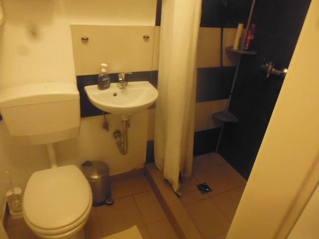
...and a small but private bathroom with a shower that has a sorta slippery floor.
And just outside out room, the closest vineyard is not even 50m away, and we coincidentally arrived just at the time of the grape harvest, so occasionally we can see the workers in the fields bringing in the fruit, right from our window.

It's a nice area, but as it turns out the closest shopping options are already a small hike away, so our first adventure here in Trier should be...
A Rather Rainy Resupply Run
23-Sep-2020Distance: 4.2km
Ascents: 100m
Duration: 1.5h
The closest supermarket is located about 2km away and 100m up atop the nearby Petrisberg ("Peter's Mountain"). That puts it about 10 STEPs away, meaning it's in comfortable cycling distance. Unfortunately, we don't have any bikes, so we have to walk.

The next unfortunate circumstance is the weather. You may have noticed that the weather thus far was remarkably nice and sunny. However, it is here and now that our streak ends. It started raining just about when we first arrived at our stay place, and since it's already well into the afternoon and the forecast says it'll just keep raining until the evening, we eventually decide to brave the rain and set out up the hill. Fortunately, the rain lets up about halfway up, and we get to see a faint rainbow in the distance. However, by that time the two of us are about as wet as the road.

As we crest the top of the hill, we notice a strange structure that looks like an abandoned sand crawler. We should eventually get a closer look at that thing, but not today.

Eventually, we arrive at the supermarket, which turns out to belong to a regional chain of Rheinland-Pfalz and the Saarland that goes by the name of Wasgau ("What District").

We soon find everything we need, and on the way back note that we are apparently again in a part of Germany where "Zentrum" is written as its Latin root form of "Centrum".

As we walk down the valley road, we consciously notice the perpetual traffic jam here for the first time. Owing to a skilful combination of traffic routing, a roundabout, traffic lights, and the fact that the road is steep enough to give some cars trouble hill-starting, the cars usually move uphill at an average pace slow enough that you can beat them by walking fast. That perpetual traffic jam persists through most of the day, and only lets up during the night.

On our way down, we also get a good look at the Thiels-Burg ("Part's Castle"), a little mock-castle built in 1910 as a memorial to the Prussian subvention of viticulture in this area. The castle is pretty much just a single fat round tower, but it sure looks scenic, surrounded by the colorful autumn foliage.

And with that, we arrive back at our stay place, wet, and with the belated knowledge that we could have stayed dry by delaying our tour for another 20 minutes, but oh well. At least now we have everything we need in order to prepare...
The Food
For breakfast, the theme should mostly be "we need to use stuff up". As such, the things that end up on our bread include the last of the Sanddorn jelly from Rügen, tomato paste, and even some leftover eggs.

As usual, we should eat lunch on the road during our strays, as for dinner, on the first night I should prepare all home-made Käsespätzle, starting with preparing the Spätzle dough from 2 eggs, 125g of flour, a pinch of salt and a bit of water.

In absence of a proper tool to shred the Spätzle into the boiling water, I sort of have to improvise, but the end result after boiling the shredded Spätzle for about two minutes turns out to be at least somewhat aesthetic, and very tasty.
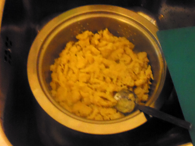
Now just fry some onions, add the Spätzle on top, and then add about 150g of Gouda...

...and before long we have a tasty and filling meal for the two of us. My late grandmother used to make this for me all the time, though I think she used store-bought Spätzle. I for my part only learned to make my own Spätzle after regretting not being able to prepare them from scratch for my hosts on my world-tours, but now I've finally gotten around to address that particular shortcoming.

On our second night Robert whips up some Gnocchi in Tomato-Mozarella Sauce...

...and as the final dinner on our journey, I prepare Tortellini al Fungi.

Now, with so much tasty food down our throats, we are more than ready for our big trip in this location. Specifically, I for my part am...
Longing for Luxembourg
24-Sep-2020Distance: 55km (49km ride + 6km stray)
Ascents: 300m (140m ride + 160m stray)
Duration: 7.5h (6.25h ride + 1.25h stray)
5/11🎁︎
Though we did not have any fixed plans to visit Luxembourg, the fact that we're this close and I spotted a bike rental at the station at the day of our arrival means that there's absolutely no way in Lerra that I won't make a break for the border today, especially since the weather forecast looks promising. And since I promise Robert that all we're going to do is cycle up and down along the Mosel, he agrees to accompany me despite our last two cycling tours. True to my word, this tour should be rather linear, taking us upstream along the northern side of the Mosel past Igel ("Hedgehog"), across the Sauer ("Sour") and into Luxembourg at Wasserbillig ("Water Cheap"). In Luxembourg, we should continue to the Mosel bridge at Grevenmacher ("Grape Maker"), where we cross back over into Germany, and then return downstream, passing by Oberbillig ("Upper Cheap"), Reinig ("Cleanly") and Weismark ("White Marrow") along the way. Of all three rides on our journey, this should be the shortest and fastest one, though due to the road not quite following the river in Luxembourg, we should still manage to climb more meters than on Sylt (see Book IV ~ Chapter 8 ~ Sylt Stray Sillyness).
[025]
Anyway, as I said, the weather today is nice, and so we're off towards the bike rental place at the central station early on. Along the way, we pass by a barber shop with a good sense of humour.

Theoretically, we could have started even earlier. However, in this case the limiting factor is the fact that the bike rental place only opens at 9:00, and even as it is, we have to wait for a few minutes in front of the store before we're allowed to check out some bikes.

Our bikes this time around are actually quite acceptable. They are not too big, handle well, and have eight gears. That puts them among the best bikes that I've every ridden but did not own.

For the first part, we want to get to the other side of the Mosel. So, we head straight through Trier...

...passing right by the Porta Nigra, Trier's famous landmark, which is an old Roman city gate dating back to AD110.

We cross over the Mosel by means of the Kaiser Wilhelm Brücke ("Emperor William Bridge")...

...and once on the other side of the Mosel, we soon enter a cycleway that we should not leave all the way to Luxembourg. From here on, the going is smooth, easy and idyllic for quite some time.

A little bit later, we pass beneath the Konrad-Adenauer-Bridge, which is not only the last car bridge before Luxembourg, but also features quite artistic murals on its pillars.

Further upriver, we pass by a sizeable arboretum, which apart from "standard" trees also features a selection of topiaries and bonsai trees.

There's also this one spot where the routing gets just a little bit interesting...

...but at least we soon see the first sign pointing to Luxembourg. Now it's only 10km to go!

Following that, we reach a piece of track where the original road was apparently not quite wide enough, so they added some sort of budget expansion.

Equally mysterious are those two strange stone sarcophagi sitting silently by the side of the street.

From there on, the cycleway continues idyllically along the river for a little longer.

At one point we pass a colony of ducks resting in the short grass...

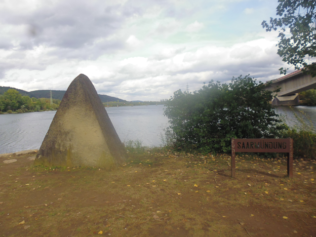
...and then, we pass by the mouth of the Saar, which enters the Mosel from the other side of the river. We should pass over the bridge we can see in the distance here on our way back later.

We also pass by the Hindenburgbrücke ("Back Castle Bridge"), which admittedly has seen better times. Constructed in 1912, it was destroyed in 1945, when it was most likely detonated by the retreating Wehrmacht, and has not been rebuilt since, leaving only the embankment standing to this date.

Aaaand, since there's supposedly a Geocache hidden up there, I naturally need to climb it. Fortunately, there's a relatively safe way to get up there by doubling around the embankment and taking the gradual ascent that the trains used to take. The more interesting part is that due to decades of neglect, the top of the embankment has literally turned into a forest by now.

However, since the embankment is mostly packed earth, it's actually quite safe, apart from maybe those few stretches where the track through the woods leads right up to the precipitous edge with no railing and a 6m drop.

In the end, I should not find the Geocache here. However, I should still get a nice view on the Mosel along the axis of what once was a proud railway bridge.

After returning back down from the embankment, we continue on our way and pass by the town of Igel proudly announcing its presence in bold letters to all who pass. This dates back to the days before GPS, when such signs were considered quite helpful by ships on the river.

We also espy a small Roman building up in the hills. Known as the Grutenhäuschen ("Grotto House-let"), this is actually a partially restored Roman funerary temple from the 3rd or 4th century AD. Originally fallen to ruin, it was partially restored in 1962, and in 2001 the upper temple part was also reconstructed.

Now, there's only a little bit of Mosel left in Germany...

...and after we pass through the little town of Wasserbilligbrück ("Water Cheap Bridge")...

...we cross the Sauer and enter Luxembourg, which instantly strikes me as a more civilized country on account of it obviously taking sensible steps to limit the number of deaths through traffic accidents.

A new country means new curiosities, such as this parking space that works great so long as you don't accidentally open the bonnet or forget that you're driving the van today.

Then, there's a boat filled with flowers...

...and also a schematic map of all of Luxembourg set in stone.

We also arrive just in time to witness the ferry crossing over from Wasserbillig to Oberbillig.

Also, there's a fisher and his son who have been waiting for a bite so long that they turned to metal. A nice detail is the cat trying to steal a fish.

After making our way through Wasserbillig, we continue upstream along the Mosel a little longer, this time on Luxembourg ground, which I suppose means that the river is called Moselle now. Or at least the closer half of the river is.

By now, Robert is already quite tired, which is why I make this next side trip into the town of Mertert ("More Tar") on my own.

My primary reason for doing so is, of course, a Geocache. However, as a nice side effect I also get to see the church of Mertert.

The next leg leads us along the Piste Cyclable des Trois Rivières ("Cycling Road of the Three Rivers"), which in its whole length follows the Moselle from Schengen to Wasserbillig, then the Sauer to Reisdorf ("Rice Village"), and then the Our ("Unser") to Vianden. The good news is that it's now only 3km to our turning point of Grevenmacher...

...but the bad news is that the Piste Cyclable leads us along the high road, which is quite a ways up the hillside, much to Robert's dismay.

Apparently, just going along the Moselle is not an option here due to some industrial area occupied among other things by the SuperDrecksKëscht ("SuperDirtBox").

Once we reach Grevenmacher, we pass by the Päiperleksgaart ("Butterfly Garden")...

...and rejoin the Moselle along the Soen a Legendepad ("Kiss a Legend Path").

In the distance, we can already see our turning point for the day: The nameless Mosel bridge between Grevenmacher and Wellen ("Waves") on the German side.

It is via this bridge that we cross back over the Moselle again...

...and with it back into Germany, where cars are still allowed to drive at dangerously high speeds.

On this side of the Mosel, the path keeps a respectable distance to the river at first...

...but eventually dares to make a closer approach.

In Temmels, the next town along the way, we come across a floor tiler with the somewhat unfortunate name of Fliesen Igel ("Tile Hedgehog"), which ranks all the way up there with Matratzen Nagel ("Mattress Nail") and Teppich Stachel ("Carpet Spike").

It is also in that town that we encounter a rather uncompromising case of THE PATH IS BARRED. Fortunately, there's a way around this particular roadblock by means of the main thoroughfare.

And on top of that, this is also where I make my lunch break on a shady bench by the riverside, eating my sandwich and Müsli bars. I say "I" because Robert by now is apparently so tired and fed-up with this ride that he just keeps on cycling.

After I have recuperated, I continue to chase after Robert, now going at the upper limit of my comfortable speed for once. Including my looking for a Geocache, Robert now has a head start of maybe 30 minutes or so. I wonder if I'll be able to catch up with him before he reaches Trier. But then again, with him not stopping to recuperate some, he can't be going very fast now.

Along the way, I encounter a family of wild geese crossing the road between myself and an oncoming car...

...and also come across a strange, monolithic monument of sorts.

Eventually, I reach Oberbillig, which is right across Wasserbillig, where we crossed over into Luxembourg just a few hours ago.

It is only on the next stretch that I, going at my fastest sustainable pace, finally manage to catch up with Robert on another long stretch near the river. He says he had every faith that I'd be able to catch up with him, and while I can't deny that, I nonetheless think that one can sustain a higher average speed and thus cover more ground in the same time by taking regular breaks along the way..

Next, we pass by Igel again. It is actually quite interesting, going the same way twice like this, but at an offset of about a hundred meters. We pass by the same places back and forth, and yet once we're up close, and once we get a panoramic view on it across the river.

Keeping up with the reverse order, the next thing we see on the far side is the embankment of the Hindenburgbrücke which I climbed earlier. Interestingly, it does not seem to have an equivalent on this side of the river.

We are now at the foot of the bridge across the Saar, and while Robert rests here for a bit I continue past the foot of the bridge and all the way to the Saarmündung ("Saar Mouthing").
Also, there's another of those mysterious monoliths nearby.

Afterwards, I rejoin Robert and we cross the Saar by means of its final bridge. From up there, we also get a nice panorama of the Mosel in both directions.

With the Mosel now at its widest again, we continue down the river. At one point, the cycleway is pinched tightly between the Mosel and the railroad tracks which we should ride back towards Munich two days hence.

By now, we are quickly approaching Trier again. Already, we can see the towers of the Benediktinerabtei St. Matthias ("Benedictine Abbey St. Matthew") in the distance beyond the Schiffsschleuse Trier ("Ship Lock Trirem").

Also, we have now reached the opposite site of the strange stone sarcophagi.

Next, we pass by the Staustufe Trier ("Weir Trireme"), which is something that we did not get to see from the other shore on account of our path being routed along strange roundabouts and through an arboretum. This is one of a total of 28 weirs along the Mosel, and we actually crossed right near another one near Grevenmacher earlier today. There's also a small hydroelectric power plant here.

A little bit later, we reach the city of Trier again, passing right in front of aforementioned Benediktinerabtei.

We make our way back through Trier along interesting backroads that are at times more cobbly than at others...

...and also have to navigate outright Byzantine traffic routings. I think that must have been the single most complicated left turn I've ever taken.

However, despite this and other last-minute confusions, we eventually manage to make our way back to the Trier central station in time to turn in our bikes.

As usual, Robert swears he'll never again accompany me on another bike tour again. However, since there's still daylight left, he's actually up for a short hike up the Petrisberg, which is more or less along our route back home anyway. So we cross over the railroad tracks...

...pass through some rustic back roads...

...and eventually reach a point where continuing by bike would have gotten really difficult.

Even as the stairs let up, the ascent just keeps going, and so within 15 minutes of hiking we have covered more altitude than on our entire 6 hours of cycling today.

Of course the upside to that is that we get a great view on Trier, including the windmills on the far ridge and the imposing Dom Trier ("Minster Trireme").

At the top of the ascent, we come across something entirely unexpected. A Japanese memorial stone. It turns out that Mutsuko Ayano (睦子 綾野 "Friendly Child Twill Field"), a young woman who was studying German studies here in Trier, died after becoming the victim of assault and robbery at this place. Having spent a year living in Japan already makes this tragedy deeply touching for me, but the fact that Mutsuko was from Okayama, one of the cities that I visited during my time there (see Book II ~ Chapter 19 ~ The Onomichi Overdrive) makes the connection that I feel here even more personal. Mutsuko died four years before I was born, and yet there is a distinct possibility that we prayed at the same Shrines in Okayama.

Moving on from this tragic scene, we pass beneath the Fernsehturm Trier ("Television Tower Trireme")...

...and end up right in the Chinese Xiamen Garden. I suppose this part of Trier harbours a secret attraction towards Asia.

We also approach aforementioned Sand Crawler, which turns out to be a walkable piece of Art known as the Turm Luxemburg ("Tower Luxembourg").

While merely an expensive vista in its own right, the true art lies in its description, which is so incredibly fluffy that I want to translate it in full length at this point:
"A tower is something ordaining, a sign or a symbol, an elevation in the landscape made to better see friend and foe.
A tower hence is ill suited to convey a sense of closeness and connectedness to one's neighbour.
Hence, the Luxembourg Tower at the Horticulture State Fair is actually more of a path opening up out of the accumulated landmark harmonically and earthbound in archaic form language.
The design is based on the thought of expressing the connectedness between the two neighbouring cities, and beyond that carry thoughts and vision even further. To that end, a linear and ever-realigning path ascends skywards, inviting those who walk it to rest and tread out into diverse cardinalities. The names of the most important places in Europe aligning with the visual axes are affixed here. Every name resonates with a certain context and its own history, thus infusing the visitor with diverse auras and sensations while ascending the tower.
At the topmost level, the visitor enters a half-open space. Through its lateral closedness, the material defines a precise and selected field of view directed towards Luxembourg City. Thus, at the end of the path a direct conenction between Trier and Luxembourg is established.
The thoughts soar past the horizon, trail off into the distance and thus make this place in Trier to a place of dreams and longing."

So much for the fluff description. My personal short version of that would be: "A perfectly good vista ruined by the fact that you can only look one way". And then, you can't even see all the way to Luxembourg because of all the hills that are in the way. The last things one can see from here are the hills near Igel and Oberbillig.

However, we do get to look down on what turns out to be a walkable geologic map of the Mosel area. A rather interesting idea, I must say.

Apart from that, there's quite a few more curiosities in the immediate area, such as a flock of pink flying sheep...

...yet another of those Mysterious Monoliths (and bet that if you conenct them on a map you'll get a mysterious triangle)...

...and what appears to be a lunar lander made entirely out of garbage glued together and painted white.

Next, we pass through the historic Burgunderviertel ("Burgundy Quarter"), which is so historic that it's effectively history...

...though some buildings yet stand and serve as canvas for spacey murals.

And then, we're finally back at the perpetual traffic jam again...

...from where we only have to walk a little bit further downhill before we're finally back at our stay place again.

That was a busy day, and though it should not yet have been our final stray on this journey, let's take a moment off now and do...
The Retrospective
All in all, this was a good place. Maybe not the best, but also definitely not the worst of this trip. We had a complete own little apartment - small though it was - and the beds were, at least for me, quite comfy (Robert had some complaints though). Food supplies were not included though, and at night it was sometimes a bit noisy. We had a bathroom as part of the room, and a free washing machine and coin dryer around the back of the house that we could use. The location was very scenic too, although it was quite a bit away from the station, and the supermarket was a hike away. It did have a bus stop right in front of the house, however. The WiFi worked fine, and it had an adequate kitchen, and finally, the price was absolutely adequate for what it offered, so all things summed up, I am satisfied with this stay place.

So much for that. Now, let us continue on the final stray of our journey, where we set out to fulfil...
The Last Objective
25-Sep-2020Distance: 22km
Ascents: 500m
Duration: 7h
4/10🎁︎
Now, if you remember the beginning of the tale, we set out on this journey with a total of four goals: Three were to visit the easternmost, northernmost and westernmost points of Germany, and those we have fulfilled by now. However, we also had an unlikely bonus goal, and today is effectively the last chance to fulfil it.
Anyway, for our final stray should lead us up and down mountains on both sides of the Mosel. First, we ascend the Petrisberg once more because why not, then head down into Trier, across the river, and up the Markusberg ("Markus' Mountain") on the other side. From there, we should proceed down the Sirzenichtal ("Very Scenic Valley"), and then hike around the slopes of the Kläschesberg ("Hammering's Mountain"), Kockelsberg ("Rooster's Mountain") and Birkenberg ("Birch Mountain") in turn. Afterwards, we cross the Mosel once more, visit the Porta Nigra, and return back to our stay place.

We set out along a path through a partially renaturated part of the Avelertal. Today, the weather is not so nice, and we are mentally prepared to cut short our stray today if it starts raining to heavily. For now, it's only cloudy though, and so we sally forth beneath a threatening sky.

This time around we climb the Petrisberg by means of a back path leading through some typical German Schrebergärten...

...which leads us to an open field at the top, with a slight drizzle falling from the clouds above.

Walking on the edge of a residential area and the untamed hillside, we come across an interesting sign. This one says:
Playing Desirable
Children and adults are allowed to laugh and frolic!
The Game Administration

Next, we pass lengthwise through the autumn-y forest atop the Petrisberg...

...and eventually emerge from the forest at the Petrisberg Aussicht ("Peter's Mountain Vista") bus stop, which features a road sign that I don't think I've ever seen before. I think it means that there's a chance for buses to turn around 800m down the road.

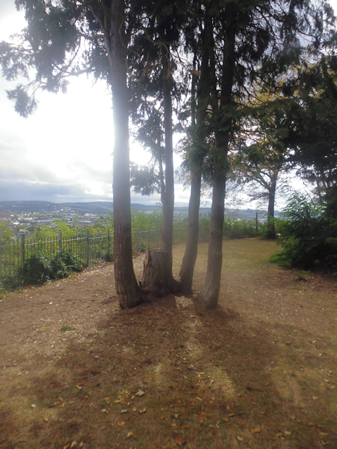
Naturally, this is a good place for a panorama on Trier, and since it's located on a corner we even get a 270° view this time.

Another curiosity up here is this amazing, futuristic solar trash can. Over are the times when you had to wire your trash cans to the wall socket or supply them with fresh AA batteries every three weeks. This amazing new invention allows you to dispose of your trash using only the power of the sun! I would have loved to try it out right there and then, but unfortunately we do not have any trash to throw away right now. Also, it's raining. Oh well.

We proceed to make our way down to the city proper through the vineyards, which ends up being a rather steep descent. Fortunately, my knees have stopped hurting by now (see Book IV ~ Chapter 2 ~ Scaling Saxon Switzerland's Serene Slopes), so I can actually manage this without any bigger issues.

Down in the city, we pass by the first of various leftovers from the Roman era. You see, Trier was originally founded in 16BC by the Romans as Augusta Trevorum, and claims the title of the oldest city of Germany. It remained a part of the Roman empire until around AN400. As a result, there's quite a number of Roman heritage sites around, such as this Amphitheatre that we are currently passing by.

We next pass through some lazy backroads of Trier...

...and eventually end up at the entrance of the Palastgarten ("Palace Garden") of the Kurfürstlicher Palast ("Electoral Palace").

Once, they were only accessible to the privileged, but today even a lowly Fox and Tanuki can enter them and marvel at their splendour.

And the Kurfürstlicher Palast is quite impressive too. Notable is the distinctly different western wing, which is the Konstantinsbasilika ("Constantine's Basilica"), a reconstruction of the audience hall of Roman emperor Constantine the Great, serving as a church these days.

We also find the Monty Python foot here...

...and then pass by the Kaiserthermen ("Imperial Baths"), a Roman unfinished building on which construction was started around AD300. However, in the end it never got finished on account of, oh, Attila the Hun sacking the city, among other detrimental events. By the way, that hill in the background is the Petrisberg Aussicht from where we just came down.

As we move on, a bus passes us by, advertising for "The-Alex-sees-Nina-oh-how-cute-steal-glances-butterglies-in-one's-tummy-have-a-total-crush-hold-hands-riding-experience". I don't think there's anything I can realistically add to that, apart from maybe "Riding the bus down not work like that." I mean, if it did, I would have first gotten laid by age 14, riding the bus to school every day like I did.

Anyway, we continue on the tracks of Roman history, passing through the city park following the course of the old city walls. Most of it is gone, and yet a low round tower yet remains.

Our next stop in Trier's Roman past are the Barbarathermen ("Barbara Baths"). Measuring a total of 42,500m², they are the largest Roman baths erected to the north of the Alps. Today, approximately on quarter of the original area has been unearthed, while other parts now serve as foundations for the surrounding city blocks after suffering an inauspicious fate as makeshift quarry and artillery training targets during the middle ages.

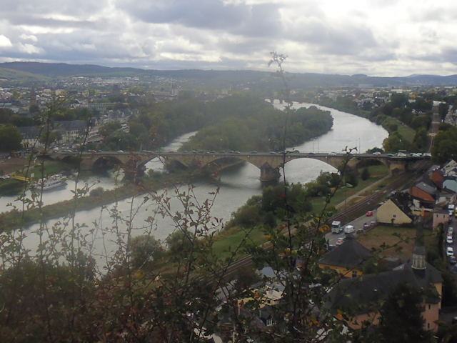
Following the Roman heritage trail one step further, we next cross the Mosel by means of the Römerbrücke ("Roman Bridge"), which also happens to be Germany's oldest bridge. Originally built in AD150 with pillars of stone and a wooden roadway on top, it has been remodelled various times through the ages. However, the pillars themselves are still the very same ones from all the way back then. Those Romans sure knew how to build to withstand the test of time.

Now for a change, a place we should not visit: The Mariensäule ("Mary Pillar") atop the Markusberg. Though we should actually climb that mountain and get within 500m or so of the pillar, we should not actually walk there on account of it not being on our route, plus the sky does not exactly say "take your time, guys".

Incidentally, we are presently approaching aforementioned Markusberg, with only a few blocks of houses still separating us from there.

Once again, the climb turns out to be one of those that is spectacularly unsuitable for bikes.

In fact, it should probably give me some food for thought that the "Staircase closed!" sign at the top of the staircase has by now fallen over and eroded away. Still, this is definitely not the worst path I've dragged Robert on now, so I think we're good.

After the initial staircase we continue at a road with an incline of "oh Dragon shoot me now" (if you're a bicyclist).

For a break from all the Roman stuff, we actually come across a Greek inscription on our way up past some of the houses. Now, my Greek is a bit rusty, but if I interpret the inscription correctly it means something along the lines of "My motorcycle garage is full of eels".

The climb thereafter continues along an autumn forest road...

...and eventually we crest the top of the Markusberg.

There, we find a humorous sign of a disgruntled horse owner. This one reads: "Intelligent humans do not feed strangers' horses. Idiots are forbidden to do so."

Our milestone up here is the St. Markus Kapelle ("St. Marcus Chapel"), after which the entire hill is named.

From here we get a good view on Trier from the other direction, including the Römerbrücke, and the Kaiserthermen beneath the Petrisberg from whence we came.

After that, we're going down, down the northern side of the Markusberg to be exact.

Doing so, we end up in the idyllic and remote Busental ("Bosom Valley"), which is only accessible through this one road, and a number of small footpaths.

There, we are looking for a sign to lead our way to the Sirzenicher Wasserfall ("Very Scenic Waterfall"). Now, while this cat in the field is very cute, and quite probably knows the way to the fall, I somehow doubt we can convince it to lead us there.

Now, this wayside chapel could certainly be taken as a divine sign, but still I think we might have more luck looking for something more concrete.

This one is again closer to what we're looking for, and it might very well be pointing to the waterfall. However, it is just a bit cryptic, and thus sort of fails the role of a guide post.

Ah, finally, that's much better. Now that wasn't so hard, no was it?

Now all we have to do is cross a bit of woodlands...

...cross a little ford...

...and then we finally arrive at the Sirzenicher Wasserfall...

...which admittedly turns out to be somewhat of a disappointment.

I figure that the prolonged sunny weather of the last weeks is to blame for this disappointing shortage of water throughput, and apparently the rains from yesterday were not enough to refill the local aquifers. After all, a picture from the archives documents the waterfall looking like this.

Oh well, I suppose it can't be helped. Anyway, following that, we continue down the valley first along a small walking track...

...which eventually expands into a dirt road...

...before graduating to a paved road.

Incidentally, there are also some really interesting rock formations along the way.

Those red rock formations line the road pretty much all the way back to the city...

...and actually also into the city, where some determined people have actually incorporated the red cliffs into their very homes.

Our next destination is a local free-admission wildlife park. Finding our way there turns out to be kinda tricky, and we get turned around twice, end up in front of a closed gate once, but eventually find an entrance in the form of a somewhat dysfunctional fence.

It is here that we almost, almost reach our bonus goal of finding the Eierlegende Wollmilchsau ("Egg-Laying Wool Milk Sow"), because this park does actually have Mangalica, which are also known as wool pigs. Originally bred in Hungary in the mid 19th century by crissbreeding native Hungarian breeds with the European boar and the Serbian Šumadija breed, the Mangalica is hardy and independent, and thus quickly got popular in Hungary. Conveniently, one of the ones here is a sow and thus also capable of lactating. That's "Wool", "Milk" and "Sow" checked off the list. Now we just have to genetically engineer them to lay eggs, and then it would be mission accomplished. Unfortunately, she's a bit shy and doesn't come close to the fence, but even from afar her dense woolly coat is clearly visible.

After checking off this last thing, we look for a back down into the valley. Unfortunately, that's easier said than done.

However, after a bit of circling around we finally do find a way down into the valley after all.

We also find something that I've been looking for for quite some time now, and that is a bench on which I can sit down for a lunch break. Interestingly enough, the drizzles up to now were apparently not strong enough to pierce through the canopy of this forest, and so the bench itself is actually still nice and dry.

Slowly returning back towards more civilized parts, we come across a gate bar which apparently once fulfilled its intended duty quite heroically. I wonder if some youths were intending to break through the barrier in badass Hollywood style, only to learn rather painfully that barrier gates these parts tend to be made of steel and not of wood.

We next ascend to the nearby Aussichtskanzel Felsenpfad ("Vista Point Rock Path") of the Moselhöhenweg ("Grouse Height Path"), which is when the sun breaks through for the first time today.
This place is located at the top of an approximately 2km long band of red cliffs, and thus makes an ideal vista point. Among other things, we can see the Kaiser Wilhelm which we crossed yesterday...
...as well as the Konstantinsbasilika and the Dom Trier, and also the Petrisberg vista point again.

Getting down from there is actually quite interesting, since we have to follow a trench path between the cliffs...

...before eventually emerging between the houses of Trier.

And then, er cross over the Mosel one last time...

...and proceed to follow the city wall park once again, this time on the other side of the city.

This one features some interesting ecological features, such as a designated Höhlenbaum ("Cave Tree") for owls and a Totholzhabitat ("Dead Wood Habitat") for beetles.

Of course there's also remnants of the city wall, some of which have been incorporated quite skilfully into the park design.

Our next destination for today, however, is the biggest city wall remnant bigger than any other city wall remnant ever™.

The Porta Nigra! And since we're now on foot and not just passing through, we can actually pass through and see the inner courtyard of this impressive structure.

And we also go through to the other side and see it from the back. Incidentally, the Porta Nigra was never actually finished, and never served as an actual functional gate on account of not being able to hold movable doors. Nonetheless, it was Trier's symbolic northern city gate for centuries. During the medieval ages it was actually converted into a two-storey church, until in 1802 Napoleon had it converted back to its original Roman form, which is the form we see today.

On our way back through the city of Trier, we also come across a few other notable buildings. For example, here's a building that not only has one wall completely covered in shingles, but also features some artful shingle emblems.

And then there's the Reichsabtei St. Maximin ("Imperial Abbey St. Maximin"), which used to be the biggest and most influential of the four Benedictine abbeys of Trier, and also one of the oldest abbeys in western Europe. Founded in the 4th century, it has seen over 5 dozens abbots until it was secularized in 1802. Today its buildings serve as a school and residential buildings.

Approaching our stay place, we cross through the Schlosspark Kürenz ("Castle Park Electin"), where we witness a strange mixture of sunshine and threatening sky.

Now all that's left is walking along a scenic back path...

...and then we're back in the Avelertal with its perpetual traffic jam once again.

We arrive just in time to witness an interesting process taking place in the vineyards behind our stay place: Whereas the lower vineyards were harvested by hand, the upper ones apparently employ some sort of harvesting machine to get the grapes in. Apparently, it is based on a trailer at the top, and then lowered down each row of grapevines, then pulled back up again and moved to the next row. With this taking approximately five minutes per row (factoring in unloading and repositioning after each row) and thissection of the vineyard alone easily having a hundred rows, that's easily a day's work per section even with the machine.
With that, our final stay is coming to a close, and... oh crap!!!
I just realized I forgot a stamp on that final postcard!
You see, Robert and I have a friend who is currently in a bit of a tight spot. So in hopes of lifting his spirits a little, we have been sending him postcards from all the places we visited thus far.

However, I just now realized that I forgot to put a stamp on that last card, and we already inserted it into the post box, and while there's a chance that it will arrive anyway, that's not a risk I want to take.
So... what to do? We bought that postcard at the Porta Nigra, which is quite a walk away, and I am not aware of any other shops selling postcards around here. I mean, I could try the supermarket, but the chances of them selling postcards are low, and since we're going to depart, like, really, really early tomorrow, buying a card tomorrow is not an option either.
Fortunately, it's not all that late yet, and we have a bus stop in front of the door with a bus that runs straight to the Porta Nigra.

So I scramble and take the next bus, which is kinda modern and kinda empty...

...and soon thereafter find myself back in the inner city of Trier again, only a block away from the Porta Nigra.

However, despite my scrambling, I find out that the visitor's centre - where we bought the last postcard - has already been closed for half an hour.

Fortunately, there are also other shops in the city which are yet open and also sell nice postcards, so I am able to secure one, fill it out, put a stamp on it this time, and post it for good.

In the end, both the card with and the card without stamp should reach him, so maybe that was a bit of unnecessary excitement. Still, it made for an unforgettable final experience of our Germany tour, and thus a fitting finale. Now, for one last time, we are looking forward to...
The Road Ahead
With this, the final stay of our Germany tour is over. After this, all that's left is the way home, which shall be covered in the next chapter of the Travelling Fox Blog.