
The town of Outram, near which I'm staying, is located at the edge of the Taieri Plain, at the foot of the Maungatua mountain range. It's a small settlement housing 642 people about half an hour away from Dunedin, principal city of Otago.
The region of Otago itself is the third-largest region of New Zealand, and most famous for the adventurer's capital of Queenstown, which is located further inland near the lakes. About 220,000 people call, this 31,241 km² big place their home, which results in a population density of only 7 people per km². Fittingly, the name "Otago" comes from the Māori language, and can be translated as either "Place of Red Earth" or "Isolated Village".

The farm in which I'm staying is actually closer to Woodside, but whereas Outram is large enough to be considered a proper township, Woodside can barely be called a village with its two dozen houses. Founded during the 1850s, Woodside used to be a village of woodcutters bigger than Outram, but by the 1880s was in decline in favour of Outram. Today it doesn't even show up on the maps any more, the only hint to its existence as an independent community being the Woodside Road and the Woodside Scenic Reserve.
Outram, on the other hand, started to thrive in 1861, when the discovery of gold in Otago brought plenty of customers to the ferry of Outram - which due to its strategic location on the Taieri River was one located directly on one of the key routes to the Tuapeka and Dunstan gold fields. Eventually, the ferry was replaced with a toll bridge in 1864, only to be destroyed four years later when a massive flood swept away all of Outram in 1868. However, the people soon re-established their town a safe distance further away from the river, and even though the gold rush eventually trailed off, Outram continued to grow into a prosperous little rural service centre. How prosperous? Well, it was the very fist town in New Zealand to have electric street lights!

The weather is clear, the temperatures are nice, and I have slept well, which makes this day perfect to turn over a new leaf, and see if my stay here might be...
An End to WWOOFing?
What happened?
Maybe it was my natural curiosity about hearing about it at the Renegades Community Centre from Caitlin, or maybe it was me wanting to try something different after the workload in my last place nearly crushed me, but either way, to find this place, I have said goodbye to WWOOF, and chosen to embrace HelpX instead.
What is HelpX?
Well, put frankly, it's exactly the same thing as WWOOF, only the places don't have to be organic farms or cultural exchange hosts. It covers more countries, the membership is cheaper and lasts longer, there are more hosts available, and the online host search interface is more tailored to my needs. On top of that, I feel I'm being more honest to myself relying on HelpX, which is all about people like me helping others out and getting food and accommodation in exchange, as opposed to WWOOF, where hosts tend to expect you to have an active interest in organic farming - which regrettably is not the path I have chosen in this life. Not that I want to brand WWOOF as being inferior at this point. I mean, true, it may be more expensive, more limited, more cumbersome, and tends to invoke expectations which I'm not willing to fulfil, but on the other hand...
...
...I'm sorry, I can't seem to think of anything.
So long story made short: With this place I am trying out a new approach to working and travelling - and as chance would have it, so is my host, Jennie. She is a kind middle-aged woman who needs a little help running her farm since she also works as a part-time veterinary, and I'm more than willing to help her out.

The Place
Jennie owns a 17 hectare big farm at the foot of the Maungatua Mountains. Unlike Thornton Grange, which was more or less flat - Jennie's Farm is quite hilly, and an overall very idyllic place.

Let me start off by giving you a little tour of this lovely place.
Next, allow me to introduce some of the four-legged companions I have in this place. In fact, you might already have met three of them during our tour.
First, we have a trio of dogs: Bess, Queen and Miro. Bess is a properly trained New Zealand Sheepdog, and the oldest of the pack. Jennie often takes her out to round up the sheep, or herd them from one paddock to another. Queen is Bess' younger sister, and quite excitable. She is not yet trained, and likes to bark a lot - a habit which she picked up from Miro, who is a likeable mutt, and a bit of a rascal.

Next, there is Purdey, the

...as well as Willow, who is quite shy by contrast, and thus eludes me every time I try to take a picture of her.
Apart from that, Jennie also has a herd of horses...

...cows both old a young...

...pigs both big and small...

...and sheep. Heaps of sheep.

Last but not least, there's also the ever-present menace of rabbits around. Did you know that four rabbits eat as much grass as one sheep? I guess it comes from having to run around all the time.
The Job
There's a variety of tasks to be done on Jennie's Farm. For example, on my very first day, I help her load up her carriage onto a trailer.

And the next day, it's off to herd sheep...
...and subsequently sorting them together with Jennie.

There's also several hedges that need to be clipped back in order to avoid interfering with the electrical fences...

...which is not as harmless as it might seem, because some of these hedges actually fight back.

My major task here, however, is splitting lumber into handy logs of firewood using the Splitmaster 4000 (or something like that).

A task that involves transporting big chunks of lumber from Jennie's extensive log backlog in the back...

...using a trusty old truck.
It's quite an extensive task, but through diligence, I eventually manage to fill up the shed with loads of firewood over the course of two weeks, and mostly unscathed too - although I accidentally moderately squish one of my fingers on one occasion,.
One of the tasks I performed at Thornton Grange also makes a comeback, and incidentally, it's the one I enjoyed most: Making a map! Jennie is absolutely taken with the idea when I suggest it, and after about three days of work and a lot of running around the farm to check on details, I present Jennie with the finished map, and she's quite happy with it.

Also, there are a number of troughs in dire need of cleaning...

...and since I have to manually scoop out the water onto the nearby ground, the pigs are especially grateful for that.

Finally, Jennie and I get on a horse sled, which is rather bumpy at first, but gets a lot better once we get onto the grass. Our actual objective is to spread the manure evenly over the paddock, and after she instructs me on how to handle the horses, she lets me go for a few laps around the paddock. And let me tell you: Driving horses is a completely different thing from driving a car. Altogether!
Interlude: The Maungatua Madness
A great perk of Jennie's Farm is that she gives me Sundays off, meaning that I have ample time to explore the surroundings. On the first Sunday, I decide to go explore the nearby Maungatua Mountains, and get a good look on the valley.

I start out by walking past the Black Forest Park, where they hold red deer. Have I mentioned that deer are more or less domesticated over here?

After a short walk, I arrive at the Woodside Glen Recreation Reserve...

...and enter the dark and foreboding Woodside Glen Track.

Well, once inside, it's actually not so bad once inside...

...but I should probably have paused upon seeing this sign.

Sure enough, the path soon becomes rather steep...

...and I eventually emerge above the tree line, under a threatening sky.

Up here, the trail is starting to become less obvious, and I have to watch carefully for the triangular red trail markers...

...but following it, I eventually get a marvellous view of the entire Taieri Plain...

...including Jennie's Farm.

From here, it's not long before I reach the ridge of the Maungatua Range...

...where the trail soon becomes completely lost to the grass, only marked by the occasional pole every few hundred meters. I navigate it more by feel than by vision, since although I can't really see the trail even while I'm walking on it, the going becomes significantly more difficult whenever I accidentally lose it.

However, soon I face another issue: The sky is closing up, and the clouds are getting dangerously close. With the trail pretty much invisible up here, and no obvious ways of leaving the mountain, that leaves me being in danger of getting stranded in the midsts a sea of mist.

Fortunately, the clouds don't drop down any lower, and while I get battered by winds and caught in a steady drizzle, I still manage to make my way to one of the peaks...

...where I manage to find one of the incentives that led me here: A Geocache!

From there, the trail just keeps going and going, leading me across the mountaintops...

...and past curious stone formations.

Yet the trail just keeps on going, and I have no idea where it will lead me. I do have internet connection up here, but regrettably, the Maungatua Trail is not marked down on any map I can find. So, I make a daring decision, and leave the trail in an attempt to force my way down the mountain through the untamed wilderness.

The grass is quite wet from the consistent drizzling, and the ground rather soggy, so my shoes and lower pants are soaked in seconds as I walk by clutches of spongy moss.

Still, I make good progress at first, and eventually manage to draw close to my goal: The next Geocache, which I figure has to be where another trail will be - one that will lead me off the mountain.

But first, I have to painfully push my way through a field of prickly shrubs, and subsequently climb down into a lushly vegetated ravine...

...and thankfully end up in a relatively open forest, which has something that might have once been a trail.

However, before I manage to find the actual trail again I first have to somehow make my way through a densely vegetated shrubland full of spiny plants and highly prickly grasses which I have lovingly dubbed "Death Stars" - a feat that takes me another hour or so.
And then, I am back on track again, and manage to make my way down the mountain by following the relatively clear path.

Eventually, I exit from the Maunguatua Range Southern Reserve...

...and let me tell you, never before have I been so happy to just walk along a straight road. It should still be another hour before I finally finish my circuit, and along the way I come by a pair of alpacas grazing on a meadow. Having seen llamas on Thornton Grange, I can now clearly see the difference between them and their smaller relatives.

It was the adventure of a lifetime! The entire hike took me eight hours, more than half of which I spent forcing my way through the wilderness. At times I sincerely thought I was going to get lost, and trapped on the mountaintops, but in the end, I made it after all. The only casualties were my shoes, which got so badly drenched and slushy that I feared they might re-enact a certain incident that happened to my father at my uncle's birthday-hike, but fortunately they held up long enough for me to make it back to Jennie's Farm, and from that day on, whenever I looked up onto the mountains, I'd feel accomplished, seeing as how I had not only managed to walk this advanced trail, but also successfully made my way back down through the wilderness.

The Food
Jennie has a strong sense of food ethics, firmly believing that those who work must be fed well. Hence, the food at her place is absolutely delicious, starting off with a nutritious breakfast of müsli with yoghurt...

...continuing to a variance of tasty lunches and dinners, such as sausage and pasta gratin. By the way, did you know that "dinner" is often referred to as "tea" in these parts? It certainly surprised me.

Sometimes I'm on my own though, and when I'm not feeling like cooking something complicated (yet tasty) with venison, I just fry myself up a couple of eggs - which with some fantasy look somewhat like the islands of New Zealand.

The climax, however, is when Jennie takes me to a dinner party, where I get to prepare my legendary pizza for the guests, and while they're sceptical at first, the first bite they take unanimously convinces them of the legitimateness of my claim. Subsequently, they ask me for the recipe, and I eventually agree to upload it onto my blog - hence my previous post.

Interlude: A Ploughman's Pilgrimage
On my second Sunday off I decide to take another stray around the vicinity. This time, however, I set my sights lower, and decide to just take a relaxing stroll to the town of Outram and back.

Along the road, I pick up a little passenger: A little dragonfly who seems to be headed the same way, so I take it along.

This little fellow has chosen a safe mode of transportation with me, unlike other critters, which sadly experience much more cruel fates by the sides of the roads. In fact, roadkill here is a significantly more common sight than it is in Germany.

My path this time just takes me along some country roads, until I eventually pass by an old, abandoned train station next to where a branch of the Main South Line railway used to run.

After that, I come by the 41st World Ploughing Contest cairn of peace, which has plates made from native rocks of all participating countries set into it - including Germany.

And before long, I arrive in Outram. Have I ever mentioned that the people here have thought up a really clever way of reminding people about the speed limit inside towns?

My way back leads me past an interesting letter-box-on-a-chain...

...and through the small village that is Woodside, back to Jennie's Farm.

The Flair
Apart from the work-related things I learn at Jennie's Farm, there are also a number of other pieces of knowledge to acquire, for example that dogs and horses can profit from acupuncture just like humans can.

Meanwhile, one of our dogs, the young Queen, likes to get herself into trouble by raiding the plastic trash and playing with it.
There's also a clock in the house which has a unique way of tolling the hour: It plays the calls of a different native bird every hour.
And speaking of birds: There's also this curious species of bird which I like to call the "Synthesizer Canary".
The next thing I get to experience is a horse getting shoed.

By the way, have I mentioned that Jennie's house has an amazing reverse dryer?

Since Jennie only has limited internet at her place, I once again do my video uploads at my local sanctuary: the library.

Since it's quite some distance away - namely in Mosgiel - I'm lucky that Jennie is happy to drop me of and pick me up again from there while she is doing business in town. Afterwards, its only a 15-minute drive across the roller-coaster like roads back to Outram.
One morning, a dense mist settles over the farm, concealing the sun just enough to be looked at directly.

And guess what famous fantasy series Jennie has in her bookshelves?

But now, to the part that this section is truly supposed to be about: Adorable cats!

Purdey is a really adorable tomcat, affectionate and daring, climbing the wine rack to look out of the window...

...or providing me with some direly needed relaxation while drawing...

...before settling down to rest on my old zipper binder, which by now has seen a total of four continents. I originally bought it in the USA and still haven't found a suitable replacement for it after 13 years.

Purdey is just outright adorable, and I already know I'm going to miss him terribly when move on - even if he sometimes runs across Liete's keyboard.

At night, the stars out here are outright beautiful, and my only regret is that my camera is not powerful enough to adequately capture their splendour.

Eventually, we get a couple of dry days, allowing Jennie to get the hay cut and bale it into big, round bales, and eventually brought in by Jennie in her tractor.
And finally, I also get to watch some sheep being shorn.

Interlude: Down to Dunedin
Near the end of my stay, Jennie takes me for a trip to Dunedin. She has to perform dentistry on some horses on the Otago peninsula, so I get to spend half a day exploring the coastal city.

My first order of business is clear: I have to replace my old shoes before they fall apart on my feet, so I go to...

...where I replace my ragged old shoes...

...with a pair of brand-new sneakers, which are available in every imaginable colour... so long as it's black.

Afterwards, I'm ready to explore the various sights of the city, starting with the botanic garden with its strange metal worms and colourful aviary.

Afterwards, I continue my path uphill, past some very sincere mail boxes...

...and along some neat sidewalks.

My goal this time: Baldwin Street, the world's steepest road. Can you guess which of the following it is?

The right answer is on the opposite side of where New Zealand would be located on a typical European world map.
I came here by special request of my great-cousin Andreas (and certainly not because there was a Geocache on top), making it all the way up in a matter of minutes, for while it certainly is steep with a maximum gradient of 35%, it's nowhere near as much as what I had to handle on my way up (or down) the Maungatua Range.

And if you think the Woolston Community Library was small, the library on Baldwin Street is even smaller.

By the way, here's an impression of just how steep this road is.

Once on top, I take a picture of passing tourists from Zürich, and in return get my picture taken by the bench and water fountain which I'm sure less fit people are quite grateful for.

Finally, I get a certificate from the souvenir shop, and continue on my way.

There are still other challenges that lie on my path, such as the dreaded Duddingstone Steps...

...but I keep on going, passing by legendary wall-art...

...and eventually arrive at the central square of Dunedin. Now, this square has something special about it. I wonder if you'll be able to find out what.

The answer lies in its unique shape, which becomes quite apparent when seen from above.

From there, I take one last stroll to the port overlooking the fjord-like Otago Harbour...

...and then it's back to Outram again. Looking back on where I've been, I realize I covered quite some distance straying around Dunedin today. Why, it must have been almost 20km, and a good measure of up and down to boot!

The Retrospective
I really liked staying with Jennie at her farm, and it is - in fact - the first of my workplaces which I'm genuinely sad about leaving. Okay, so the accommodation was only a sleep-out, but the food was absolutely fantastic, the work was varied and interesting, the facilities were pretty good, even featuring a bathtub, I got taken on trips... but most importantly of all, Jennie is just an amazing person, and her pets are outright amazing. It might not have been quite as good as the Te Horo Lodge, but it came pretty damn close.
It did however manage to take the first place for Work-Value-Ratio, which is my personal measure of how much work I was required to do in relation to what a place has to offer. In fact, so far Jennies Farm has only been the second place where I voluntarily worked extra hours because I felt I owed her that much - the other place having been the Renegades Community Centre in Christchurch.

In accordance with my tradition, I also prepare a picture of Jennie doing what she enjoys most: Riding one of her horses. Just like my other hosts, she's quite happy with the picture, and the only thing that I feel bad about is the fact that other helpers after me are going to have a hard time living up to the bar I just set as Jennie's very first helper.

The Road Ahead
My next destination is all the way south: Stewart Island, the southernmost permanently inhabited place in New Zealand.

Getting there is quite a trip, and includes changing buses in Gore, as well as stopping for a night in Invercargill. It begins when Jennie drops me off at the Mosgiel Station...

...and after the bus arrives with barely half an hour's delay, we're on our way, past sprawling fields...

...along the shore of Lake Waihola...

...and across the Clutha River in the town of Balclutha.
Eventually, we stop for a break literally in the middle of nowhere...

...and then it's onwards to Gore, where half the passengers transfer to a new bus, that will take us to Invercargill.

From here, it's only about an hour to Invercargill, and the bus mostly follows a railway line, passing through the town of Mataura along the way.
Once in Invercargill, I check into the Southern Comfort Backpackers...

...before going around a little stray to explore the city of Invercargill.

Finally, I go out on a walk to the Pleasure Bay Lagoon, a part of the considerable esturary of the Oreti and Waihopai Rivers...

...and take a beautiful picture of the sun just before it sets.

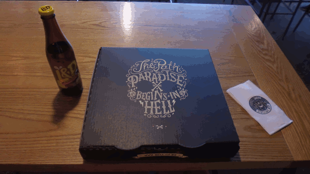
Subsequently, I finally go to hell...

...where, much to my pleasant surprise, I find they serve the damned some quite delicious pizza.
The next morning, I'm off to the final parts of my trip to Stewart Island. Since Invercargill curiously doesn't have a port of its own, I first have to take a bus down to the port town of Bluff...
...where I get on a significantly smaller ferry...

...and then we're off, racing across the waves to Stewart Island.
The entire trip takes about an hour, and then we arrive in the beautiful Halfmoon Bay....

...where I meet up with my next host, and go up to her house on top of the hill.

There, I settle into my comfortable little bedroom, happy to finally have a room in a house for once, and prepare myself for my adventures here on Stewart Island. I've made it to the far end of the ends. Who knows what this place has in store for me?
