- Fantastic Fasching
- Kümmerlings-Karma
- Embarking Eastward
- The Touristic Town Tour
- The Three River Cross Weave Stray
- Donau Deggendorf Dodge
- The Road Ahead
Last year, I went over the jobs that I had, and how I ended up changing jobs twice the year before, and finally ended up BVK, which I then declared to be the best work experience I've ever had (see Book V ~ Chapter 5 ~ Düsseldorf & Delphi Derby). Now, one year later, I can only reaffirm that statement, and if anything, things got even better. Since then, we've had a staff outing to Wasserburg, which I did not explicitly cover here on account of me having already completed a Petal Ride there (see Book V ~ Chapter 4 ~ Project Petal Part 6 ~ The Easterly Expedition), and this year, in 2023, we already had a number of fun events.
But before I get to that, let me show you one long-term project of the BVK that I hope to see the completion of. You see, ever since I started there last year, talks of a big construction project for a new, modern office buildings with the fancy name of Tridea have been going around, and this year construction finally started. More than just another office building, though, this project is standing under the banner of sustainability, with the BVK actively aiming to combat climate change not only with this project, but also many other investments it makes. Originally scheduled for completion in 2025 I think, delays through the Green Shnolz Pandemic have pushed back the date until 2028 by now. Then, they needed to survey the grounds for unexploded bombs from WW2 (which are still occasionally found throughout the city during construction projects just like this one, even though the war is by now over three quarters of a century in the past), thus causing further delays. Honestly, I'd be surprised if it actually gets finished this decade. Which means that in order to see its completion, I'd have to stay at the BVK for longer than all my previous jobs combined. And yet, I do hope that is going to happen, because I really, really like it here.

With that having been said, let me now go over the exquisite events that I attended at my new place of work this year, starting with...
Fantastic Fasching
21-February-2023
"Fasching" is the south-German term for carnival, and the BVK is very supportive of that age-old tradition in that it not only sponsors a cool event, but also gives its employees half a day off to enjoy it. And with me featuring an award-winning Kitsune-outfit (see Book III ~ Chapter 7 ~ Home), I'm obviously gonna attend.

The venue is the Casino, the 5-star company cafeteria, which has been adequately decorated in festive colors, glitz and glitter. My co-workers wear all sorts of fancy costumes, and some have even brought their kids to attend the event.

Apart from standing around, eating and drinking, one can also hit the dance floor, which is something that I eventually do. However, I quickly learn that dancing with Geta (the traditional Japanese wooden sandals) is kinda tricky and uncomfortable, so maybe next time I'll try to arrange for a more agile costume.

And if the Geta didn't complicate things enough already, there's the issue of my traditional Japanese Kitsune mask restricting my field of vision somewhat like this.

But anyway, apart from food, drink and dance, there is yet one more thing that this event has in store, and that is a freaking dance show from a local theatre group, how awesome is that?

And that is only the beginning, because two months later, I should get to enjoy some prime...
Kümmerlings-Karma
27-April-2023
Two months down the line, another neat event comes along. It is time for the BVK's cabaret troupe: The Kümmerlinge ("Care-lets", a pun on "Kämmerlinge" ("Chamber-lets"), which is the collective noun for everyone working at the BVK).

This time, the Casino has been remodeled to feature a fancy stage on one end, and there's free food and drink included by courtesy of the management.

Its starts of strong with an artistic light show display featuring fancy programmable twirling batons that are designed to draw pictures and patterns into the air when twirled around. No idea how that works, but it sure looks cool
(Click here to view the video if the website fails to load it)
What follows thereafter is a ruthless parody that I can only describe as an unparalleled mark of confidence in the benevolence of our collective employer, because the amount of parody and sarcasm involved surely would have gotten me fired in 3 out of 5 companies that I worked in before. It starts of with a "game show", the name of which (G.I.G. = "Gewinn ist Geil" = "Winning is Wicked") is a allusion to the name of the currently ongoing restructuring program of our IT department, in which I, too, was marginally involved. The original name of said program is also G.I.G., standing for "Gemeinsam IT Gestalten" ("Designing IT Together"). The participants are all actors and include an over-zealous yuppie, a nervous gray mouse, and a government clerk named Herr Schrecklich-Träge ("Mr. Terribly-Slothful"), who is very insistent about his double-name.

That show also features a number of cameos, such as the ChatBot Inka, which lives on our company's intranet page and which, in light of the recent developments with ChatGPT, I can at best describe as "cute".

The name of our big, ongoing new office building construction project also gets dropped, incorporated as the name of a fictional sponsor "TriDeA", standing for "Triumph der Atmung" ("Triumph of Breathing"). In fact, that one should later on pop up again in the form of a faux product commercial for Betriebsklimaanlagen ("Company Climate Conditioning Machines")-

Both the TriDeA sketch and the next piece also pick on a topic that has been a sore bone ever since the Green Shnolz lockdown ended: During that lockdown, literally the whole staff got to enjoy 100% home office, but after the lockdown ended that was dialed back to 50% again, which to be fair is still 50% more than what people had before the pandemic, and yet at least 25% of what people came to expect. To make things worse, flimsy explanations were given and an ostensible long-term study was mounted, none of which the employees were particularly happy about. And on top of that, the rules and regulations surrounding the Dienstvereinbarung Flexibles Arbeiten ("Establishment Agreement Flexible Working") as this construct is called are somewhat confounding to all those which don't have a background in programming or mathematics - which is a sizable percentage of all employees. Enter this sketch featuring Doc Brown from "Back to the Future" explaining how all of this is actually a ploy in order to build his new Flex Compensator and go "Forward into the Past", which incidentally is also the title of this year's show.

And then there's more, such as one sketch lamenting the conditions that the cleaning people work under, or a jib at misguided sustainability efforts, such as the replacement of sponge clothes in the kitchen with silicone cleaners, which had the effect that if someone spills something now they have to mop it up with disposable paper towels where in the past they could use the sponge cloth. And in the end, there's a heartwarming goodbye to the chief of troupe who retires this year, and thus has been part of the event for the last time. Also, dancing.

So much for this refreshing performance. Now, let us get to the main event of this chapter, which should begin with me and a good number of co-workers...
Embarking Eastward
25-May-2023Ride Duration: 2.5h
Approximate Distance: 175km
Average Speed: 70km/h
Roughly one month after the Kümmerlings-show (a lot of nice things seem to be happening near the end of various months here), it is time for the first staff outing of the year. The destination of this one is the actually kinda distant city of Passau ("Pass Meadow"), and the long drive to get there is actually one of the reasons why many of my co-workers take a pass on this one. I, however, don't think I've ever been to this city, and as such I am quite eager to get up at 5AM on the day of and make my way to the office by 6:45AM to claim a seat in one of the rented coaches.

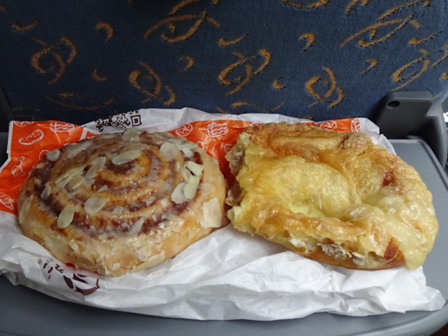
On a normal day, it takes me roughly 2.5 hours from waking up to sitting in the office, but today I did hustle a bit by skipping out on breakfast, which I now catch up on, sitting in the bus and waiting for departure. Retrospectively, I probably would have had enough time for a breakfast at home, but with the last bus leaving at 7:30AM and the ever-looming risk of the public transit part of my incurring a delay in the order of 20 minutes, I really didn't want to risk it. So here I am, sitting in the bus, quite relaxed, and eating my breakfast in the shape of a Nussschnecke and a Käsebretze ("Cheese Pretzel").
The route that the bus takes leads first east along the A94 highway, past Dorfen ("Villageing"), Mühldorf ("Mill Village") and Kirchdorf ("Church Village"). Quite a few villages that way it seems. Then, we turn north just short of the Austrian border, following a state road parallel to the river Inn, which from there on marks the boundary between Germany and Austria. Passing Sülzbach ("Aspic Stream"), we eventually transfer to the A3 highway, and Passau is only a short ways off from there.

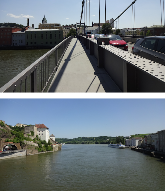
This bus ride is mostly done beneath grey skies, though the weather gets progressively more sunny the further north we go. Since we're leaving from the east end of Munich and headed east, it doesn't take long for us to leave the city behind, after which we race past fields and over hills for most of the ride. Eventually, we cross the river Inn (we do that twice actually, though I only captured one), and during the non-highway segment also pass quite close to houses as the state roads usually lead squat through the villages unlucky enough to lie in their way. Finally, we arrive in Passau, where the inner city is notably densely settled, with large, multi-story buildings coming right up to the road.
(Click here to view the video if the website fails to load it)
Now, I mentioned that there's a segment where we have to drive on state roads, and indeed, there's a part here where there's no highway for over 50km. Naturally, that's unacceptable for a country the last great invention of which was the car, and such a construction of a new highway in this segment is already well underway.

And that is something that boggles the mind. The earth dies screaming from climate change, caused in no small parts by cars and other forms of fossil individual traffic, and what does the government do? "FUCK the environment, it's in the way of my CAR!!! Bulldozes over nature, sacrificing the future."

But anyway, after a few hours of a bus ride, we arrive in Passau, specifically the shared bus- and boat-terminal conveniently located between he old city and the river Donau.

It is from here that we should begin this city trip in the most cliche
way possible, namely...
The Touristic Town Tour
Distance: 1.5kmAscents: 25m
Duration: 2h
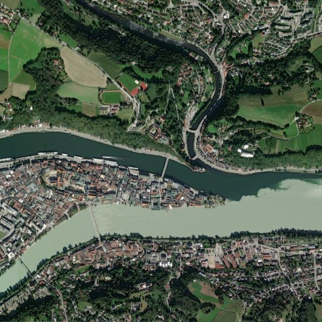
Before we get started, here's a little lore on Passau. It is the easternmost city of Bavaria, and also the closest city to the three country point of Germany, Austria and Czechia. In fact, getting to Austria from here would only entail a 2km walk. Czechia, meanwhile - at a distance of 42km - would certainly require a bike. A small university city of only about 50,000 inhabitants - roughly 12,000 of which are students - Passau's coat of arms features a red wolf on a field of silver.

Also known as the Dreiflüssestadt ("Three River City"), it was formed around the confluence of the two great rivers Donau and Inn with the considerably smaller Ilz. One unusual thing is that the three rivers join one another in basically the same spot, with the Ilz flowing into the Donau barely 200m before the Donau joins the Inn. Another curiosity is that although the Inn is both wider and carries more water than both the Ilz and Donau combined (on average 738m³/s against the Donau & Ilz's combined 690m³/s), the river is still called "Donau" after the merge. The main reason for this is historical and based on the fact that the run of the river Donau was a major trade route for hundreds, if not thousands of years, running from west to east at this point, while the Inn ran south to less economically significant reasons. Other factors that might have played a role in this naming is that the Donau features a more steady flow of water while that of the Inn fluctuates between double and half, leaving it actually contributing less water than the Donau in 7 of 12 months, then peaking in the summer months, thus explaining its higher average. Also, as mentioned before, the flow of the Donau runs west-to-east, while the Inn turns of at a 90° angle towards the south after a few km, so from a pragmatic point of view it might make sense to let the river that runs most straight inherit the name.
But anyway, back to the city tour! With four bus loads of Kämmerlingen here, the BVK has organized for roughly a dozen city guides so we can split off into smaller groups. Joining one of those, I soon find myself following an elderly lady with a telltale red round fan into the heart of the old city, along with a dozen of my co-workers.

The tour route is somewhat short by my standards, and the pace is rather relaxed. For the most part, we walk from one corner to the next while our tour guide tells us all sorts of fascinating little trivia about Passau, it's history, and the buildings we walk past on our route through the Altstadt ("Old City").

We start in the Höllgasse, the name of which deceptively does not translate into "Hell Alley", but rather "Swamp Alley" on accounts of it being rather close to the Donau, and thus prone to flooding. It was turned into an artists' street rather recently - in the 90s - and since then does feature not only colorful buildings, but also colorfully colored cobblestones leading up to the doorsteps.

The next interesting thing we come across are the stone arches spanning between the buildings, and which our tour guide tells us exist for static reasons. The side roads with their steps are clearly not made for cars, but rather historically for horses, with long, low flights of stairs spaced specifically with equine anatomy in mind.

Another curiosity are the roofs, which are a bit unusual in design. From the outside, they look like flat roofs with windows out of which rain gutters emerge. Known as a Grabendach ("Trench Roof"), this is a very local architectural style found primarily in the areas surrounding the rivers Inn and Salzach. An advantage of this construction is that the low roofs and the frontal guard wall somewhat reduces the risk of fires spreading - a bane of cities until the invention of electric light. In fact, I already encountered this type of roof during the last staff outing in Wasserburg, which is also located on the Inn.

Now then, I did mention flooding, which is something that both Inn and Donau feel like doing every now and then, and one of the downsides of being located in the crotch of two major rivers is that only one of them needs to flood and the whole lower city goes down the drain. As such, in cities like this you can often find marks recording the water marks of historic floods, and Passau is no exception. The highest flood in recorded history reached a peak of 13.2m above the normal water level, and was enough to completely flood the ground floor and second floor of the buildings here in the Höllgasse, and even reach the third floor of some.

Standing in front of the city hall, we get a good view at the Veste Oberhaus ("Fortress Upper House") located on the cliff between the Ilz and the Donau, overlooking the city below. Originally constructed in 1219, it was the seat of the Lord Bishop ruling the city of Passau, and it was continuously expanded until the year 1800, with the prominent number 1499 on the city-facing wall recording the date at which the middle part was constructed. The original, and most fortress-like part is the rightmost part, and features another little curiosity: Because it was designed to be a castle, the lower to rows of windows are actually not windows at all, but rather window-like fresco designed to provide an appealing look while still being easily defensible.

The next attraction is the Scharfrichterhaus ("Headsman House"), which owes its name to an insistent rumor that this is where the city's headsman used to live in olden time. Nonsense, our guide declares, for headsman was a shunned profession in said olden times, and the headsmen had to live outside of the cities. Whatever the truth is, however, the house takes pride in the name it has gotten, and today features a locally famous cabaret theatre. And building on the theme, they hold a yearly contest where they award the artist with the sharpest tongue with the Golden Headsman's Axe.

After that, we continue on to the St. Michael Church, which was constructed under the supervision of Italian master builder Pietro Francesco Carlone in 1677.

Next, we proceed down to the shore to the Inn, our guide confidently leading us down a path marked as closed due to flooding, while we warily follow her through the narrow alley.

Turns out the flood has receded since morning - which our tour guide naturally knew - but even so, the Inn still runs quite high, with the water level being only a hand's width below the walkway, on which puddles from the earlier flooding still persist.

On the hill at the far shore, the Wallfahrtskirche Mariahilf ("Pilgrimage Church Mary Help") can be seen, complete with a roofed stairwell leading up the hill side. At this point, I don't know if I'll have the time to visit it, but I definitely mark it down as a potential destination for later on.

Leaving the Inn behind, our guide next leads us through what must be the most crooked alleyway in all of Passau: The Zinngießergasse ("Pewter Alley"), which does not only go between buildings, but also beneath buildings.

Next up is the Residence, located right next to the great St. Stephan Cathedral.

This one has some curious doors with a half-meter drop to the road, and our guide explains to us that these were "carriage doors" where in olden times the horse-drawn carriages would pull up, allowing the highbrow passengers to step right into the residence from the carriage, which I imagine might have been quite a boon given the elaborate dresses of those days.

We also get to look inside for a bit, if only to see the square stairwell with its impressive fresco and painting at the top.

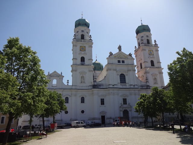
The guided tour ends in front of the St. Stephan Cathedral, where our guide tells us about how this cathedral holds the world record for the largest organ, featuring 229 registers and a whopping 17,974 pipes, the largest of which are as tall as power poles, and the smallest of which are only a few centimeters in height. Again, I make a note to check it out if I have time later on. In fact, I would check it out right now, but since there's a concert ongoing right now, that's regrettably not an option.
And with that, the town tour comes to an end, and while others take their time to coordinate with their co-workers about what to do next, I for my part am off like the wind, because I have already made my plans, and I fear that time will be the great limiter in how much I'll be able to pull off. This should result in...
The Three River Cross Weave Stray
Distance: 14.5kmAscents: 320m
Duration: 4.25h
5/8🎁︎
In a city of three rivers - all of which within walking distance - and some hills in between for scenic views, it is pretty clear what I'm gonna do. Basically, the plan is to cross all the three rivers using a different bridge each time, while also going up to the Veste Oberhaus to get a nice view on the city, ideally getting Geocaches on each of the four slices of land that I visit en route. To do that, I first head west to near the central station of Passau and then north, crossing the Donau for the first time. From there, I make my way to the Veste Oberhaus via a very exciting and roundabout way upon which I will elaborate shortly, before going down into the valley of the Ilz, stitching across and back again. Then it's south over the Donau, to the very point of the confluence, and then south across the Inn. There I briefly chase after a Geocache to the east and then head west to the second-to-last bridge across the Inn. And after that, I already have to race to make my way back to the bus in time, no time for any further detours.

But one thing after another. For starters, I am still within the old city of Passau with its narrow streets and curious passages, such as the Paulusbogen ("Paul's Arch"), which is more than a gate, namely a 25m-long old road tunnel beneath the annex of the nearby St. Paul church.

At this point, my primary concern is grabbing some quick lunch along the way, and so I figure making my way through the pedestrian zone at the heart of the Altstadt is a good way to go

Somehow, I fail to find something like a food stall however, and so in the end the lunch I find is a slice of Pizza at a Turkish cuisine eatery in the city mall. Conveniently this place has a menu deal that comes with a soft drink, and although I did bring a full liter of water, with the weather being quite warm and sunny today, I am grateful for any extra liquid that I can procure at little cost.

Leaving the city mall behind, I soon pass a little Thai restaurant with the name "Der Weiße Thai", which is a pun on the German title of the movie "Jaws", which happens to be "Der Weiße Hai" ("The White Shark"), so I suppose a fitting translation would be something like "Thais"

Shortly thereafter, I cross the Donau for the first time using the Schanzlbrücke ("Redoubt-let Bridge"), doing so just as a sightseeing boat passes beneath. Doubtlessly, a number of my co-workers are on that boat, enjoying a relaxed three-river sightseeing tour. And there's absolutely nothing wrong with that, but me being the hyperactive little fox that I am very much enjoy straying around like this.

On the other side of the river, the terrain starts getting really steep really quick. Fortunately, most of it is in the shade of trees, but even so this slope is quite taxing, and definitely not one that I would want to ride my bike up, what with it having a gradient of over 10%.

However, at the top of said slope a hidden gem awaits: The Schloss Freudenhain ("Palace Joy Grove"), which on account of all the trees surrounding it is well-hidden from the city below.Constructed in the late 18th century, the imposing structure has served as a school for over a hundred years now.

From there, I follow a painted-on footpath next to a slow-drive road up the hill...

...and then a somewhat more adventurous forest path down a little valley. Definitely not bike-worthy, that one.

Eventually, I'm back on the road, only this time around it's of the sidewalk-less variant. At least there's not a lot of cars around on this one. It sure is hot though, and so I'm glad for whatever little shade the trees provide.

However, the plus of this little detour is that I come by a scenic view point giving me a nice few of the city of Passau, featuring both the St. Stephan Cathedral and the St. Paul Church.

Before long, I leave the main road behind in favor of a little side path...

...which again is rather steep and falls in the "I definitely don't want my ride up this"-category.

Looking back, I get a good impression of how high I've climbed by now. At this point, I'm actually already a hundred meters above the Donau.

After some time, I cusp the high hills, wandering along the level ground for a while...
...before running into a rare specimen of the Common Field Car (bmwus standaroundis).

My general plan is to walk east from here - more or less parallel to the Donau - until I reach the Veste Oberhaus. However, I end up taking a wrong turn and consequently find my path barred by THE DOOR.

So I end up backtracking and choosing a "safe" route this time. In retrospective, the map says there should have been a faster middle way, but standing there on the crossroads it didn't look quite like a path, and with me already having lost time and being under pressure, I chose the safe route this time around.

Turns out that wasn't a bad idea, because that path eventually leads me past the Lilac House®.

From there, I follow the hilltop main road east for a while. On the plus side, this one has a sidewalk. On the minus side, there's no shade, and the day is - as I was saying - quite warm.

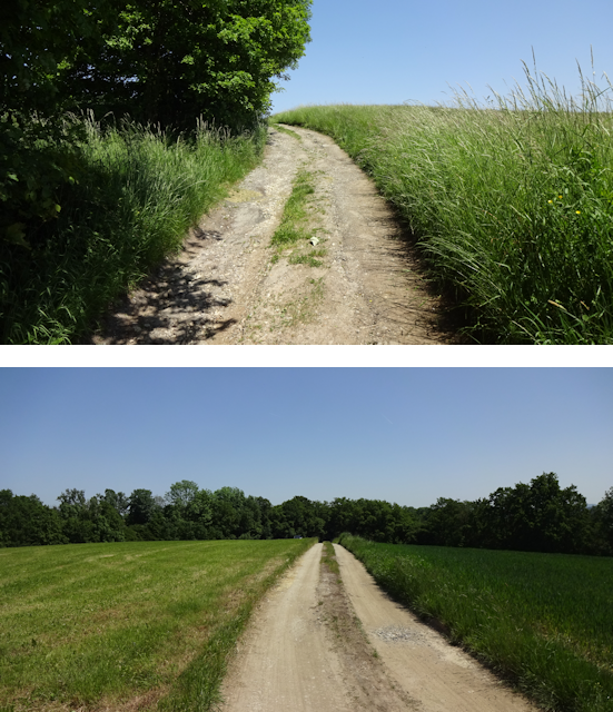
Eventually, however, I turn south again on a more rural path, this time checking my map to make sure I'm on the right track.

Though both the map and I are right regarding the path, however, there is no accounting for unforeseen circumstances, such as the path in question presently being closed.

"Not a problem", I think, because I can see that there's another path south to the Veste Oberhaus just a little bit further to the east along a path branching off from here, so I go about following that one instead.

But noo, whereas that other path was closed for no readily apparent reason, that other path is closed for very apparent reasons, and since today is a weekday, the construction is actually presently ongoing, so I can't just quickly sneak across either.

Long story made short, after a detour through the fields and two left turns where I wanted to go straight and right respectively, I end up back on the Hilltop Main Road again.

Third time's the charm though, and the next time I try turning towards the south, I finally manage to make my way all the way to the precipice of the cliffs, and consequently get a nice panoramic view of Passau below.

The clifftop path that I consequently follow is nicely shady and cool for a change...

...and then I finally reach the Veste Oberhaus itself around 13:45, which leaves me with a little over 2 hours before the buses depart again.

From up here, I get a nice view of the confluence between the Donau and the Inn, as well as the wedge-shape of the old city below. Part of the hills on the far side of the Inn belong to Austria already, by the way.

I look around the interior of the Veste for a bit, but not for too long, and only in the parts that I can access for free. After all, at this point I still have two rivers to cross, and over half of my stray time has already passed, which puts me just a little bit under pressure.

As a result, I hurry down the 75m of altitude from the Veste to the Ilz valley rather quickly, which - in combination with the fact that this is my first major hike this year - turns out to be a rather bad idea, and has the consequence of me becoming the Fox whose Knees Hurt for the remainder of this stray.

Down at the valley floor, I walk parallel to the Ilz for a bit, taking a scenic rout through the Bschütt Park ("Debris Park"), which features a number of curiosities, such as a turnable "totem pole" featuring the history of this place on 8 plaques, complete with historic photographs, drawings and maps, or an XXL-version of that analogue hand-held game where you need to navigate little balls into shallow holes by tilting the game field, then somehow keep those balls in there while you navigate in the others.

In the middle of that path, there's a foot-and-bike bridge across the Ilz, which I subsequently cross, getting a nice view on this idyllic little valley as I do (though it would certainly be even more idyllic without that big road running straight through it.

It is said road that I follow down the valley for a bit, walking past colorful houses as I do, and though that road only has two lanes, I can't help but notice that the road takes up more space than the houses built alongside it, meaning the existing development consists primarily of road. Oh well, at least that includes a reasonably sized sidewalk (no trees for shade though).

Eventually, I leave the road behind in favor of some stairs leading to a Geocache. The stairs take me up roughly another 20m or so - an effort that is immediately rewarded by the boons of shade and leaving the kinda busy road behind.

Atop the stairs awaits a very idyllic little walkway leading me all the way to the back gate of the St. Bartholomew Church's little cemetery.

From there, I have to go downhill again, which my knees immediately acknowledge as a rather bad idea, but there's nothing that can be done, and thankfully it's only 20m. After that little ordeal, I am now standing on the Ilz-side of the river trident, looking out on the points of the two wedges of land in the river-trident. The near one between the Ilz and the Donau is dominated by the Veste Niederhaus ("Fortress Lower House"), which as the name indicates is the downhill-counterpart of the Veste Oberhaus. In fact, the two are connected by a roughly 200m-long chain of battlements running down the ridge, and I think they are even open to the public part, but not all of the way.

Subsequently, I cross back over the Ilz by means of its very last bridge, which connects to a tunnel cutting straight through the escarpment atop which aforementioned battlement is situated.

The last bridge across the Donau before the confluence - the Prinzregent Luipoldbrücke ("Prince Regent Luipold Bridge") is located almost immediately on the other side of that tunnel, and so I end up crossing both of those rivers in less than 5 minutes.
On the other side, a Geocache leads me to make a 270° right turn that ends up with me following the promenade of the Donau, heading for its point of confluence with the Inn, crossing beneath the bridge I just crossed as I do.

Walking down the promenade, I come across a looong ship, the River Adagio. Okay, so, maybe it's not really long in comparison with other ships, but what sticks out is it's extreme length-to-width ratio. With a length of 125m and a width of only 11m, it is effectively over 11 times as long as wide, which kinda makes it look like an oversized floating popsicle stick.

A little later, I arrive at the easternmost point of my stray: The Dreiflüsseeck ("Three Rivers Corner"), marking the confluence between the Inn and the Donau.

Looking to the left, I get one last view of both the Veste Niederhaus and the Veste Oberhaus beyond on the ridge separating the Donau from the Ilz...

...while my way leads me to the right, along the Inn and past the sun.
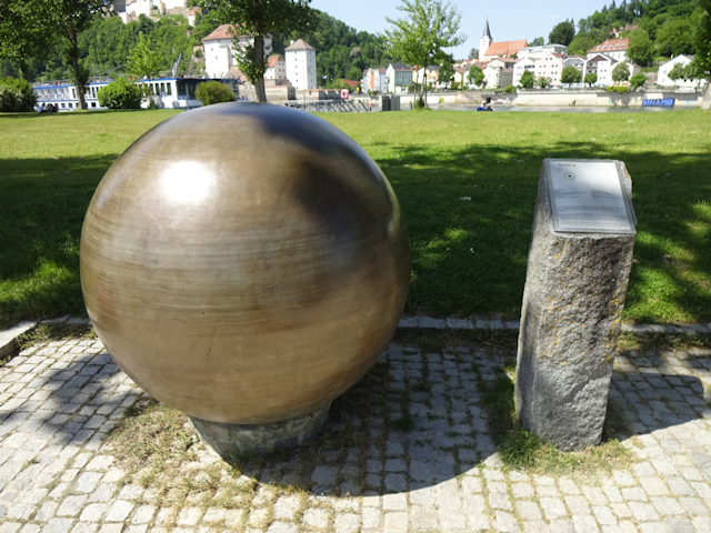
Turns out just like Munich and many other places, Passau has a Planetenpfad ("Planet Path") as well, along which scale models of the solar system's major bodies are spaced in intervals true to scale. As such, it doesn't take me long to pass Mercury and Venus as well.

After that, I have to walk along the Inn promenade for a bit...

...before coming across Earth and Mars. Looking at those two plaques, I realize that each plaque has two little metal orbs, one representing its own size to scale, and the second one representing the relative size of Earth for reference (naturally, Earth is lacking the reference orb).

Moving on, I next pass beneath the walkway connecting the city to the Schaiblingsturm ("Disc-er Tower"), which was built in 1250 as a watchtower, and later repurposed as a magazine for gunpowder. Later yet it became a pier for salt trade, and until 1957 there was even a rope ferry across the Inn anchored at this tower.

Shortly thereafter, I cross the Asteroid Belt, which is marked with a plaque referencing the Asteroid Passau, a relatively small asteroid with a diameter of "only" 20km that was discovered in 1990. Still, that's big enough that it would not only be able to bury all of Passau, but in fact most of Munich (the official city area of which measures roughly 26km by 20km).

At this point, I realize that I have crossed paths with the earlier city tour as I pass the Zinngießergasse again.

It has been a little over 4 hours since I was here earlier, but in that time the Inn's water level has receded notably. Whereas earlier it was a hand's width below the promenade, now it's over an ell. Also, by now all the puddles on the promenade have yielded to Radian's resplendent might.

Next, I pass might Jupiter...

...before temporarily leaving the solar system as I cross the Marienbrücke ("Mary Bridge"), the final Inn bridge before the confluence.

On the other side, I follow the Inn downstream for a while, walking parallel to a decommissioned railroad track. My heart weeps at the sight, and I wonder if I'll live to see a brighter future where I walk or cycle over decommissioned highways instead.

At my turning point, I find the final Geocache for today, meaning I have achieved all but one of my primary goals. At that point, there's also a billboard nicely putting the size of the Inn in contrast to the other two rivers, while also pointing out a number of places I've been to today.

My final primary goal for today is crossing back over the Inn via a different bridge, and so I make my way west through the narrow roads of Innstadt ("Inn City"), as this part of Passau is called. In fact, Innstadt composes most of the little piece of Germany that occupies this side of the Inn, with the river marking the border to Austria for 20km downstream and well over a 100km downstream (counting the Salzach and the Saalach too). Basically, this here is the only little patch of Germany on this river-bounded piece of landmass.

I also pass near the Walfahrtsstiege ("Pilgrimage Stairway") to the aforementioned Mariahilf Kirche. However, on account of both the time (at this point, I have less than one hour left to finish up and make my way back) and my knees, I'll have to give going up there a hard pass, and instead settle for straying through the blissfully level alleys of Innstadt instead.

Doing so leads me past the Fuchsgassl ("Fox Alley-let"), which also features a flood mark from the 2013 flood on the corner of a building

A little bit further on, I cross back over the Inn by means of the Fünfersteg ("Fiver Plank"), another little foot-and-bike bridge.

And with that, I'm back inside the solar system again, just in time to say hi to Saturn, which is also the final planet of the Planetenweg that I have time to visit today. Uranus is roughly twice as far away from the Sun as Saturn, and Neptune would nearly double that distance again. Meanwhile, the clock is down to nearly half an hour, making the notion of doing pretty much anything other than returning to the bus now a "Very No"-thing.

My "more or less beeline" back to the bus takes me straight through the Klostergarten ("Abbey Garden"), a reasonably-sized green square with water installations in the heart of the old city.

Situated on one end of the Klostergarten, there's the Stadtturm ("City Tower"), an L-shaped building which not only is of prominent design, but is also fashioned from some sort of green-ish stone, possibly some variant of marble.

Afterwards, I hurry back through the valley-like streets of the old city...

...only briefly stopping to take note of the at least slightly designed manhole covers featuring the wolf as the heraldic animal of Passau, along with the phrase "Leben an drei Flüssen" ("Living at three Rivers"). It doesn't come close to the highly individual and colorful manhole covers I've seen in Japan, but at least it's a step up from the generic manhole covers of Munich.

Soon thereafter, I reach the final stretch as I reach the Donau's promenade...

...and then, I arrive at the bus stop with roughly 15 minutes to spare. Enough to be comfortable, but definitely not enough to have fit anything else in.

Oh well, I did complete my primary objectives, crossed all three rivers on six different bridges and found at least one cache on each wedge of land, so there's that. I didn't get to see the cathedral organ or climb up to the Mariahilf Kirche, but I guess that's okay. For now, my legs are quite happy that I get to sit back and relax during the...
Donau Deggendorf Dodge
Ride Duration: 2.25hApproximate Distance: 190km
Average Speed: 84km/h
On the way back, the bus takes a slightly different route. And with "slightly" I naturally mean "completely". For starters, we head northwest towards Deggendorf ("Ceiling Village"), more or less following the run of the Donau upstream. There, we then turn a bit more to the south and follow the Isar all the way to Munich, passing by Dingolfing ("Thing Golf Caught"), Landshut ("Country's Guard") and Freising ("Free Sing") along the way. Combined with the way there, this interestingly forms a petal that looks somewhat like a three-fold enlargened version of the Tiger Petal (see Book III ~ Chapter 11 ~ Project Petal Part 2 ~ The Ruprechtsberg Ride).

However, it is there and then that I suffer a double failure: First, my camera's power runs out, and secondly, I have to learn the hard way that apparently after 6 years of trusty service, the power bank that I had bought in Christchurch, New Zealand, has also reached the end of its lifecycle. Fortunately I still have my tri-Comm2, and while I don't think phones will ever replace proper cameras for things like taking snapshots or movies, it'll have to do for now.

The bus ride itself first takes us past the forests and through the hills north of the Donau as we head towards Deggendorf via the most direct route. We narrowly dodge Deggendorf, turning south just before the city and cross over the Donau, now following the Isar instead. From there on the terrain changes to mostly flat farmland, with only a few ponds and forests in between. We also cross back and forth across the Isar a total of three times, and finally arrive in Munich through the Windmill Gate, formed by the two windmills that Munich has, located near Fröttmaning. And after that, we only have to cut through a little bit of the city, and then we're back at the BVK.
(Click here to view the video if the website fails to load it)
And from the BVK, it only takes me about another hour to finally make my way back home, taking the U4 to the Odeonsplatz ("Odeon Square"), then the U3 to Moosach, and finally my bike back home.

With that, this trip and thus this chapter comes to an end, which brings
us to...
The Road Ahead
Well, what's next? I might have already mentioned it at some point, but there's another big trip coming up this year. But that is then. Before that, a number of other, smaller, but still interesting things should happen. For example, there's one thing that I've approached on from two angles already, and this year, the third time should make the charm. What is it, you wonder? You will be able to find out in the next chapter of the Travelling Fox Blog. So until then, stay tuned, and be of great cheer! =^,^=