A blog about the travels of Kira Resari, the once and future travelling fox
GDPR Privacy Statement
By the new GDPR law, I am required to make you read the Silly Privacy Statement. That statement doesn't really contain anything unexpected or surprising to people used to the internet, but by accessing and reading this blog you agree that you've read these statements and agree to how this blog uses your data.
On a related topic: If you say something to somebody else, the brain of that person might store the information you told him/her not anonymized and without your explicit consent and use it against you at a later time, and if you leave your house people just might see where you go and what you do.
...that was the day and time when I first set foot on the South Island.
Now, on the 16th of May 2017, I should finally depart from it after a stay of six months and nine days. I've officially spent more than half of my working holiday on the South Island (if you count the 15 days I spent on Rakiura as part of the South Island), and have grown to like the landscape very much. As such, this departure is particularly meaningful, especially since I don't know whether I'll ever return to this place.
But alas, the winds pick up, and I spread my wings to soar to a new place yet again. The days are getting shorter, so the sun is yet hidden behind the horizon by the time I set out in the morning. I take one last look at this wonderful place, and then I'm on the road again.
This particular trip is rather unique, since I complete the three different legs using three different modes of transport: First its over to Picton by bus, then across the Cook Strait by ferry, and finally onwards to Collingwood by train. It's not all manageable in one day, so I stay the night in a hostel in Wellington, before catching the early train to Collingwood.
Part 1: A Completed Circuit
No bus runs out to Cable Bay, but fortunately, John is happy to take me out to the closest InterCity bus stop on his way to work, and drops me off near Hira, where I wait in front of the General Store to be picked up...
...not without noticing that the place has great taste in advertising.
However, what started out as half an hour of waiting soon turns into a tantalizing test of tolerance as the scheduled departure time passes me by, as well as a total of three travelling buses which don't even bother to slow down. Did my booking go amiss? Am I now stranded out here while my ferry departs without me? And why didn't I write down emergency contact numbers for the InterCity support hotline to call in a situation such as this? These thoughts thoroughly torment me as I stand by the side of the road with my luggage, desperately waiting and hoping that the bus is merely late.
Fortunately, the latter is the case. I don't know how it's even possible for a bus that's only just departed Nelson as its first stop for the day - which is 15 minutes away - to be half an hour late, but albeit, that seems to be the case. Oh well, for the most part, I'm just glad that this crisis has been averted, and with relief make my way aboard in anticipation of the journey ahead.
The route may seem a little bit roundabout at first, but since this is one of the shortest bus routes on the entire South Island, it can afford to make a little swerve to the south and connect Blenheim to Nelson, before continuing on to Picton. The route takes me up the mountains, across a pass, and then through a number of valleys, until I ultimately cross the Wairau River, and return to the Wairau Valley, where I've completed my first stay on the South Island half a year ago, and where the vineyards are now ablaze with the golden colours of autumn. With that, my loop around the South Island is finally complete, and all that's left now is to travel down the length of the valley to Blenheim, and then up north to Picton. This marks the end of the first leg of my trip...
...yet not without having seen a number of curiosities on the way here, such as the Mussel Pot Inn, or a giant yellow iguana this time.
Interlude: A Pit-Stop in Picton
From the time the bus arrives in Picton, I still have two hours until the ferry leaves. Time enough for a stray around town, and to pick up something to eat along the way. But first, I check in the bulkier part of my luggage in the terminal, and note that the conditions should allow for a fine crossing today.
My stray should lead me along the picturesque waterfront - which is indeed so picturesque, that somebody just up and framed it...
...and past the Edwin Fox museum, which houses the world's 9th oldest surviving ship.
Some ways along the promenade, I come along a commemorative plaque to Captain James Cook, who was the first European to discover that New Zealand actually consisted of two islands. When the dutch explorer Abel Tasman first "discovered" New Zealand in 1642, he travelled along the west coast of both the North and South Islands, but mistook the Cook Strait for an extensive bight, which he named Zeehaen's Bight. It was only over 100 years later, in 1769, that James Cook established that it was - in fact - a strait, and thus imprinted his name on yet another place on the world.
There's are also some colourful, and surprisingly tame ducks around...
...along with conveniently placed Geocaches (and they're not even past their expiry date yet).
By the way, have you ever wondered how people get around these fjords? Some people own their own boats, but as a tourist, you can also go by taxi.
And there's a pedestrian's bridge also known as Coathanger Bridge, from which I get a good view of the arriving InterIslander Ferry as it prepares to dock at the terminal.
As I wrap up my stray around Picton, I come across its share of war memorials...
...before purchasing a delicious mushroom and steak pie in a café which curiously bears my name (translated from Zeritij), and consuming it in the waiting lounge of the InterIslander terminal, expecting the time of departure, and enjoying my last minutes here on the South Island.
Part 2: A Cloudy Crossover
Not much later, it's time to board the Kaiarahi (Māori for Leadership), together with quite a notable number of uniformed students (or multiformed, since there appear to be groups from different schools), who must have been returning from a field trip.
Incidentally, we're not the only passengers aboard the ferry. A herd of cows also makes the trip to the north island. Unfortunately, their accommodations are significantly less spacious than mine, and also don't offer anywhere near as good as a view.
It's still a bit before we actually depart, so I take the time to familiarize myself with our route back...
...as well as the spacious ferry. I quickly realize that it can't be the same ship I took on my trip to the South Island, since the floor layout is radically different. Apparently, the InterIslander fleet consists of three ferries - the Kaitaki, the Aratere and the Kaiarahi - which alternate their duties of ferrying people and goods across the strait, with two of them being in service simultaneously, while the third one undergoes regular maintenance. This particular ship features an open-air viewing deck, along with lateral sidewalks, and a forward-facing lounge - complete with a café and kid's corner.
And then we're off! Out of Picton Harbour and into the Grove Arm of Charlotte Sound, passing the Snout, Waikawa Bay and Whatamango Bay, before taking a turn into the Tory Channel. It's almost two hours into the 4.5 hour crossing before we finally clear the sounds and enter the Cook Strait, where we soon pass the inbound ferry on the halfway point. Outside the shelter of the sounds,, the wind picks up considerably, whipping me around and chilling me to the bone as I stand alone on the deck, filming, and nonetheless grateful that this time around I can at least see Then, another two hours later, we pass through Fitzroy Bay and enter Wellington Harbour, where the wind continues to blow relentlessly. We pass by the lighthouses of Pencarrow Head and Makaro - or Ward Island - and the sun has already set by the time we finally land at the InterIslander Terminal in Wellington.
After the docking procedure is complete...
...I take the free shuttle bus to the Wellington central station...
...from where my hostel for the night - the Hotel Waterloo & Backpackers - is just across the street.
Interlude: A Welcome in Wellington
Incidentally, I've made plans for this very night. Oxillious, a sibling fox and creator of worlds much like myself, would like to meet me, and so we have arranged a meeting on the one night where I pass through Wellington. Thus, I leave the hostel right after checking in, and make my way to the centre of town, where I unexpectedly run into quite a commotion.
It's the Lux-Festival, which is celebrated all over the central city with bright lights and colours. They may be a month early for the Festival of Lights here, but then again, I wouldn't have been able to attend it had they held it on time. One of the main events is an animated circus show projected onto the wall of a tall building, which I watch to pass the time while waiting for my vulpine friend.
And then, Oxillious makes his appearance. Just like me, he's hard to miss, even when not wearing his tail.
Talking about our respective projects, we stroll through the streets of Wellington, and eventually arrive in...
...where we have a bottle of Karma Cola each, and a bowl of authentic African cuisine big enough to feed two hungry foxes.
The evening quickly flies by as we engage in spirited world-building discussions, and before long, it's time to head back, through the Lux Festival again, and into the hostel. After all, I'm up to en early start tomorrow.
Part 3: A Carriage to Carterton
The last part of my trip would take me from Wellington to Carterton.
Wellington is one of the two places so far in which I've neither arrived nor departed by bus (the other having been Oban): Back in November 2016, I arrived in Wellington by train and left by ferry, and this time around, I arrived by ferry, and am leaving by train. That was also one of the reasons why I chose a hostel right across from the station. Getting up early, it only takes me 5 minutes to walk to the station after checking out - yet somehow, I feel like rather than in Wellington Central, I've instead arrived in King's Cross.
Since I still have some time until my train departs, I sit down in a café near the platform and eat a humble egg-and-bacon sandwich while watching the daily masses of commuters arriving from the suburbs pass me by.
Afterwards, I get onto the modern suburban train...
...where I notice an unusual billboard that involuntarily reminds me of a musical number from the Lion King.
Before long, the train is on its way, and while the weather is quite wet in the beginning, as we drive along the shoreline of Wellington Harbour and through Lower Hutt, but as we travel up the Hutt Valley, it gradually becomes better, and by the time we've reached Upper Hutt, it has at the very least stopped raining. Subsequently, we pass through a tunnel under the Tararua Range, and soon emerge in the Wairarapa Valley. Just as we leave one of the side valleys, the great Lake Wairarapa can just barely be seen in the distance. It's name means "Glistering Waters" in Māori, though personally, I like to call it "The eye of the fish". From there, it's mostly a trip through farmland, and not long after, the train arrives in Carterton.
Along the way, I also notice a herd of deer in one of the many pastures - although the fattened up specimens here have little in common with the lean and agile animals found in European woods. It makes me wonder, though, how graceful and agile cows must have looked before they were first domesticated.
Epilogue: A Sparky Start
I don't have to wait in front of the Carterton station for too long before Sparky comes along and picks me up.
Driving out of town and past the fields, it's only a short time until we arrive at her farm, where I'll be helping out for the next two weeks.
It's a lovely big place...
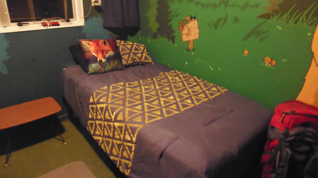
...and for some peculiar reason, I am instantly enamoured with my sleeping quarters.
Sparky should soon set me to work, and I for my part should soon find this place quite enjoyable. But that's a different tale, and shall be told at a different time. So stay tuned for more tales from the travelling fox.
Once again, I find myself in a new place, and this time around, the winds have blown me to...
With an area of only 424 km², the Nelson Region is the smallest region in New Zealand by an entire order of magnitude (followed by Auckland with 4,940 km²), but with 50,000 inhabitants still has more people living in it than either Tasman, Marlborough or the West Coast. On a global scale, that would make the Nelson Region about the size of Barbados, with the population of the Marshall Islands, and the population density similar to France, Ghana, or the United Arab Emirates. In effect, the Nelson Area is constitutes the city of Nelson, along with the eastern coast of the Tasman Bay, and parts of the mountains separating it from Marlborough. Also - as you might recall from Chapter 18 - Nelson is the geographical centre of New Zealand, so even though it's the smallest region, it's still quite easy to find on the map.
As for me, I'm currently staying in a place a little bit to the northeast of said centre: An idyllic little community known as Cable Bay, which is located at the shore of the eponymous Cable Bay.
A beautiful and tranquil place, where I should feel like I'm...
Gardening in Eden
This time around, I'm helping out an older couple who have been living here for a long time. John works as a teacher in a museum, guiding tours for schools and organizing field trips, while Cher is a business communications coach, focusing on healthy work environments for both employers and employees through improved communication.
Now then, let me get straight away to telling you about...
The Place
What have we here? What have we here?
What have we here? What have we here? What have we here? What have we here? What have we here?
Yes!
A veritable gemstone sparkling at the shore of a lagoon!
A place of hills and ocean, a symphony of land and water, a graceful combination of sophisticated elegance, the forces of nature singing in graceful harmony to create a place not without a certain je nais se quoi.
I know it now and without a doubt! For sure, there can be not a trace of uncertainty, not now, and not at any time in the future:
I have found the most beautiful place on Earth!
The geography of the Cable Bay area is about as unique as it comes: Right across from the Cable Bay Community, there is Pepin Island, the most peninsular peninsula ever, connected to the mainland only by a narrow, yet perfectly natural gravel bank...
...and while the Cable Bay Community originally started at the western Cable Bay, it has since stretched all the way along the coast of the Wakapuaka Estuary...
...which is divided from the northern Delaware Bay by zig-zag pattern of sandbanks...
...which make the tides extreme to the point where one can safely traverse it with a boat on high tide, yet walk almost all the across to Pepin Island on low tide.
By now, it's quite late in the year on this side of the globe, and the sun rises only at about eight o'clock, filtering through the trees as it ascends over the hilltops of Pepin Island.
As for the place itself, John and Cher have a spacious country house...
...with a most unusual floor plan, and a stranger yet roof plan.
But I guess it's easier if I just show you around directly.
The place also has a clever roofed open-air drying system...
...and most importantly, a cosy, warm fireplace.
There is also a number of cute little birdies flitting around...
...including the ever-adorable Fantails, which I'm going to miss very much...
...and a number of coy Wekas are a common sight to these gardens.
As the weather shifts from sunny to cloudy, the flair of this place progressively shifts to downright mystical...
...and even while being buffeted by downpours, the place radiates a certain serenity.
It's hard to imagine that a place more beautiful than this should exist somewhere on this planet, and so it's not long before I set out to explore it over the course of...
Interlude: The Cable Bay Walkway Stray
Walking a complete circuit would be a bit much for one day, so I'm happy when John offers to give me a lift to the other side of the mountain Drumduan, allowing me to take the walk back to Cable Bay at a leisurely pace. This route should take me to the coastal settlement of Glenduan at the foot of the mountain, before continuing along a hiking track known as the Cable Bay Walkway all the way to Cable Bay.
I start out quite early at the historic St. Andrews Pioneer Cemetery...
...and make my way down the road to Glenduan.
In the distance, I can see the peaks of the Tasman Mountains, which have just received the year's first snow overnight, and are contrasting against the horizon in a resplendent white.
Soon enough, I arrive at the coast of the Tasman Bay...
...from where I can observe a curious mirage, making the opposing coast appear to be composed of steep, colourful cliffs along its entire length.
The township of Glenduan is located in the wedge between hills and ocean...
...and the people here are apparently of the creative sort, finding clever ways to make even cumbersome containers blend in nicely into the neighbourhood.
The Cable Bay Walkway begins at the end of the road, and soon takes me up the hill and above the houses of the village...
...although some people apparently couldn't resist building their house in an extra-scenic position. I'm sure they get a marvellous view from up there, but woe to them if they forgot the milk while shopping.
Continuing onwards through barely obstructed forest paths...
...I soon get a wonderful panorama view of the surrounding area, with Nelson's distinctive harbour just visible in the distance.
From here, the path continues across pastures. At this point, I feel I must clarify the New Zealand definition of "path". Unlike the European notion of a clearly visible dirt track which is easy to follow, a walkway here in New Zealand often consists only of trail markers, which are often placed hundreds of meters apart, with untouched grass in between. If you can't see the next trail marker from your current position, your best bet is to guess and walk in a likely direction, hoping that you'll come across another trail marker before too long.
At the highest point of the walkway, I catch a glimpse of D'Urville Island, which is the biggest island of the northeastern fjords of the South Island. Looking at it on the map, you'd think that the area consists mostly of islands, but upon closer inspection one realises that the northeastern fjords are mostly composed of intricately nested peninsulas, and include only two bigger, and a handful of smaller islands.
After this, the walkway takes me through some easier to follow forest tracks, and across a number of shallow fords (more like fordlets, really)...
...and before long, I find myself standing on the most idyllic alpine pasture I have ever seen - together with a fair number of woolly bovidae.
The walkway now continues along the ridge of the hills all the way up to Cable Bay...
... taking me not only past sheep, but also turkeys, a herd of goats, as well as a single cow.
It's not quite all that high up, and yet the moon seems to be just within my grasp.
Looking west, I see the sun paint peculiar patterns onto the surface of the Tasman Bay...
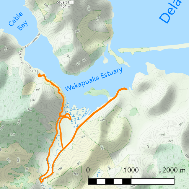
...while looking east, I can see the Wakapuaka Estuary in its beautiful teal glory.
Eventually, I arrive at the peak of Sentinel Hill - which is the hill overlooking Cable Bay - and take a minute to take in the incomparable panorama.
Now, all that's left is a rather steep descent, which connects to the road just next to the natural causeway to Pepin Island, and even though the island itself is private land, I take the time to at least walk across the causeway to the end of the public road, and gaze over to the Cable Bay Community from the opposing shore.
Can you imagine owning an entire island (or peninsula, to be exact)? Apparently, the price of this lovely jewel is only 3,000,000$, which is about the same amount you'd have to pay for a house in the middle of Munich. Only here, you get an entire 600 hectare island for it!
My final stop on the way back home is the memorial which commemorates the terminal station of the Eastern Extension Cable Company, and the very reason why this bay is called Cable Bay: At the 21st of February 1876, this bay was where the submarine telegraph cable from Australia was brought ashore, connecting New Zealand to the rest of the world. From that point onward, it was possible to telegraph a message from New Zealand all the way to London, along a complex network of cable passing through Sydney, Darwin, Singapore, Madras, Bombay, Aden, Suez, Alexandria, Malta, Gibraltar and Lisbon. This amazing accomplishment now allowed people from the different corners of the world to communicate almost instantly (aka 4 days for sending a message from one end to the other), as opposed to the 6 months which a letter routinely took. Things have sure changed from then, haven't they?
But enough about my leisurely exploits in this wonderful place. Next, let me tell you a bit about...
The Job
For the most part, I am helping John and Cher with maintaining their garden, which includes tasks such as retrieving lopped-off branches from all around the property and prepare them for subsequent mulching...
...cutting bamboo poles...
...or manually turning seven hectolitres of compost.
Another day, it's up to me to harvest silverbeet...
...before washing and drying it, and subsequently turning it into silverbeet pie.
There is also the deck to be sweeped...
...and dried weeds to be transferred to a trailer.
Speaking of weeds, this is also where I once again encounter Tradescantia, my old enemy.
On the not-so-sunny days, I instead spend my time inside, chopping apples into tiny slices...
...before dehydrating them in the Excalibur Food Dehydrator.
As the weather clears up again, I set out to my next task of clearing the mussel chip garden paths of weeds...
...before subsequently topping them up with fresh mussel chips.
And finally, there is also the berry cage, which needs to be at least partially liberated from weeds...
...and falling leaves to be collected and bagged from all over the garden. Eventually, these are going to be used in the compost, but for now, I'm just putting them in bags and stacking them in the garden.
Interlude: The Māori Pa Stray
My next excursion should take me east across the Wakapuaka River, and down Māori Pa road, as close to the mouth of the estuary as one can get on public roads.
Originally, I had planned to borrow John's bike for this trip. However, my plans are put on hold by a sudden influx of flat-tire-syndrome.
Oh well, never mind. It's not that far away, so I can walk, and as I make my way down the Cable Bay Road, I soon come across a scenic view of the estuary at low tide.
Along the way, I collect a cleverly disguised Geocache...
...before turning off the main road to head into the Cable Bay Scenic Reserve through a tunnel of green.
Eventually, the "trail" takes me all the way down to the Wakapuaka River...
...where I spontaneously decide to wade right across the shallow stream (certainly not because a Geocache is beckoning on the other side).
There, I'm still separated from the Māori Pa Road by a difficult stretch of wetland...
...but fortunately, there also is a path which takes me to the road on a drier, albeit a bit roundabout route.
Just a bit later, I reach the end of the public road. From here on out, it's private territory, so I can't go any further than this. However, I still get a great view of Pepin Island across the estuary.
On my way back, I follow the road all the way this time, and soon come across a giant, red iguana on a wall...
...as well as a rather questionable fence design.
Now, all that's left is walking down the length of the Happy Valley (yes, it's actually called like that)...
...and I arrive back in home just in time for a late lunch. Perfect time to talk about...
The Food
Days here at Cable Bay routinely start with a nice, big bowl of home-made müsli, and a cup of tea.
Later on, there is lunch, which typically includes some sort of bread...
...while dinner is the most savoury meal of the day, being composed of various all-organic ingredients, yet prepared in a way that is still yummy.
Also, there's nothing like some good old salad to give me some extra energy while I'm on fire working on the Chronicles of Ceal.
On occasion, it also falls to me to create a tasty meal for John and Cher, such as the traditional Gamm Ligeral...
...or my legendary tri-Tail Pizza, which once again completely blows my hosts away.
Interlude: The Hira Ride
One of these days, John manages to get the bike's flat tire fixed, enabling me to go on an extended ride. For the sake of completion, this ride should first take me a bit towards Glenduan, before turning around and heading for Hira, and a little bit further.
My first stopover is the historic St. John's Anglican Church, where I arrive just in time to see the sun right across its gable.
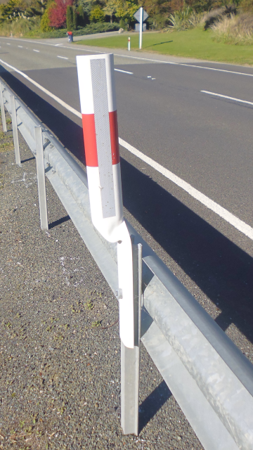
From there, I turn west up the road of severely warped reflector posts...
...and ye olde fence 'o red teapots...
...before turning around and going back east to Hira, which is really only a small rural community, and probably has a lower population density than Cable Bay, thanks to it being spread out over the width of the valley.
After crossing the Wakapuaka River two more times further upstream...
...I eventually arrive to chill out at at a rather cool place - although I appear to have come here yet a bit too early.
Next, I challenge a steep and windy mountain road...
...along the side of which I observe a group of feral chickens...
...and finally clamber up a wild stream in search of one last cache.
Curiously, this particular part of the road marks the border between Nelson and Marlborough, although the road only actually enters Marlborough another 20km down the road. For whatever strange reason, a tendril of Marlborough simply extends into Nelson here, not following any geographical feature nor roadway, apparently completely whimsically. Not even John or Cher could tell me the reason. In fact, up until I mentioned it to them, they were not even aware of this cartographical curiosity.But whatever the cause, thanks to it I was officially able to cycle all the way to Nelson, making this the only occurrence so far where one of my excursions officially took me all the way to another region of New Zealand (back in Manawatu-Whanganui, I only crossed a district border within the Region).
The way back is pretty much easy going, rolling the road down the mountain - although a ruthless SUV driver almost oushes me off the road and into the ditch, honking and screaming madly as he passes me by with breakneck speed, and at a distance that would give a sardine claustrophobia.
However, the endless sky soon manages to alleviate my shock with a collection of charming cirrus clouds, appearing as brush-strokes against the sprawling ever-blue canvas.
Returning to the estuary, I once again find it devoid of water, which makes for a stark contrast to the azure surface of the Delaware Bay past the sand banks in the distance.
And then, it's only a few more minutes until I reach Cable Bay - which is all the better considering the bank of clouds that can be seen amassing in the distance.
The Flair
Naturally, there are all sorts of curiosities to be found around here too. For example: Is this a garden path or an irrigation channel?
Here's a note to ruthless SUV-drivers straight from Glenduan: You're not welcome here!
And if you ever need to kill somebody in his or her own home, you now know where to enquire.
Here's one of the downsides of Geocaching: For example, the hint for this one was "Under a rock, where else?"
Also, on one of my strays, I come across Baba Yaga's mailbox, and quickly decide to move on before she deigns to devour me.
This cloud was obviously sponsored by Rareware - creator of great games such as Donkey Kong Country, Diddy Kong Racing and Banjo-Kazooie.
And the beta testers of this mass-produced product packaging obviously did not take their job very seriously. How long will it take you to spot the embarrassing mistake?
One night, we sit together with the neighbours around a fire and watch the sun set over the bay...
...while another night, Cher and John throw a big welcome party for some of the new neighbours...
...and there's both food (note about New Zealand parties: it's customary for everyone invited to bring a contribution of food and/or drink, resulting in buffets such as this one)...
...as well as song.
By the way, for all those of you that are yet struggling to find the perfect way to peel garlic: I have mastered the perfect way to do it quickly! Separate the toes, chop of the head (but not the tail), and then cut it in half. Now put it into the microwave for about 20 seconds, and viola! The skin should just come off with a single pull. Credits go to Pete from Autumn Farm for showing me the basic technique, and to this humble fox for refining it.
Back to the topic of Geocaching. Apart from caches - which generally stay in the same place - there are also trackables. The point of trackables is to transport them from one place to another, taking them on a journey in the process. Some of them have a distinct goal, like getting to a certain Cache, or being taken overseas, while others just roam the world freely. At this point in time, I have a total of three trackables with me, some of which I'll probably drop off somewhere in New Zealand, while others might accompany me all the way back to Germany.
If you've ever looked up cooking recipes on an English website, you might have encountered obscure, non-standardized units of measurement, such as "a cup of flour" or "a tablespoon of sugar". Not very helpful, since cups and cutlery can come in all sorts of different sizes. But fear no more! To avert this dreadful crisis, the kitchenware industry has devised a series of remarkable devices: Standardized measuring cups for the units "cup", "tablespoon", and "teaspoon", along with smaller measuring cups for common fractions, such as 1/2, 1/4 and 1/8. What a breathtaking innovation! The founding fathers of the metrical measurement system would surely be awestruck!
And by the way, that's not a leaf...
...that's a leaf!
Interlude: Pepin's Paddle and the Dragon Tidepools
This last side trip should be quite unlike any other one so far, and would take me up the Wakapuaka River, then to the mouth of the estuary, and finally to the western shore of Cable Bay.
How so? Well, it all begins with Cher and John inviting me on a canoeing trip on a sunny day. It's been quite some time since I've last been aboard such a craft - if memory serves correctly, that would have been in 1996, in Austin, Texas - so John offers to ride the Canadian Canoe with me...
...while Cher accompanies us aboard a kayak.
And then, we're out on the waters of the Wakapuaka Estuary, with me sitting in front and taking care of propulsion, while John in the back sees to steering.
Our first destination are the wetlands at the mouth of the Wakapuaka River...
...where we pass closely by a flock of spoon-beaks perched atop a fallen tree...
...before rowing our boat gently up the river. Some way up, we cross the place where I waded across the stream about a week ago at low tide. Now at high tide, the waters are so high that I'd have to swim - which technically makes this part of the river belong to the estuary as well, since clearly the ocean reaches all the way up here if its affected by the tide.
Soon after, we turn around and head north from the mouth of the river, passing by Bishop's Peninsula, which is also known as Turtle Island due to its shape.
Since the tide is currently rushing out, we barely have to paddle to make our canoe speed across the sparkling waves...
...and pass by a notorious shallow known by the locals as Bell Rock as a homage to the Scottish Inchcape Rock - though for now, it's yet completely submerged.
On the nearby hills, one can still see the overgrown scars of previous landslides, and it makes me wonder whether the reason for New Zealand's unique landscape features lies in a combination of a humid climate and frequent earthquakes accelerating the national erosion process.
A short time later we make landfall at one of the sandbanks forming the border of the Estuary. Well, to be fair, "shellbank" would probably be a more adequate name, since the beaches appear to be not only covered by seashells, but rather completely consist of them.
With this, we're officially on one of the far reaches of Pepin Island now. Glad for this opportunity to stretch my legs after sitting in the canoe and paddling for over an hour, I take a look around the unique geography of this place. Turning counter-clockwise, I effectively follow the flow of the water as it rushes out of the estuary, and through the channel between this sandbank and the next one.
We can't actually paddle into the channel since the current would push us out into Delaware Bay, and paddling back would be a considerable challenge, so instead I walk along the shore of the sandbank until I reach the mouth of the estuary.
As it is, the tide is already against us, and we have to paddle our canoe across some very shallow stretches, grazing the bottom at times...
...and by the time we finally make our way back, the sun has already made its way to the other side of Pepin Island.
But there's still a few hours of daylight left, so I resolve to extend my stray and attempt to reach a Geocache which eluded me before, which goes by the name of "Dragon's Den". Located along the western coast, near the Cable Bay Walkway, I had originally intended to grab it during my first stray, but quickly abandoned the thought in face of the considerable incline of the hillside.
This time, I am trying a different approach: Instead of climbing the walkway and then descending to the Geocache, I intend to round the cape of Ataata Point at low tide, and if necessary climb up from the shore. The only other option I can think of would be walking up the beach all the way from Glenduan.
So, I walk across the rocky beach...
...and past a veritable lagoon of tide pools...
...only to find that even at low tide, Ataata Point is still untraversable on foot.
Oh well, at the very least I am privy to the pristine waters of this beautiful coastline...
...as well as a good view of Pepin Island's western coast.
However, as the sun is already getting low in the sky, and it's a bit of a walk from the beach up to Cher and John's place, I soon depart, not having found what I was looking for, but taking quite a good number of beautiful pictures as consolation prizes.
The Retrospective
It has been quite some time since I last stayed in a place I enjoyed as much as Cable Bay. The accommodation was a wonderful single room with a big and comfortable bed, a heater provided for the cold nights, and a desk for working on, the food was regular and plentiful, and tasty blackcurrant juice was a welcome variation to my usual diet of water. Work was okay, with a very fair work-freetime ratio, and the atmosphere was good. There was not only a shower, but also a bathtub available for use, as well as a washing machine and unlimited WiFi. By far the strongest point, however, was the incomparable area, and the fact that I not only had a bike, but also a canoe to explore it by. I'm sincerely going to miss this place, and whatever other places I come by on the rest of my journey, they'll have to compare to this little corner of Eden.
After leaving the Te Horo Lodge, I didn't really expect to find another place that would earn a ★★★★★ rating (see Chapter 7 ~ Honouring Te Horo), but alas, I stand corrected. Great job, Cable Bay, and thank you, Cher and John, for letting me stay in this wonderful place!
As such, I'm more than happy to prepare the traditional piece of gift artwork for them - depicting John as a Chamois, and Cher as a Dolphin - and John and Cher are happy to receive it.
The Road Ahead
The next leg of my journey should take me to Picton by bus, and then to Wellington by ferry. There, I would spend a single, unexpectedly eventful night, before finally continuing to Carterton by train the following morning.
It does not quite compare to the West Trip Story, but it comes close, and as such, I have decided to devote the following chapter entirely to this three-fold journey. So stay tuned for more tales from the travelling fox!