This is the second of the three key destinations of our Germany tour. We are now in the northernmost state of Germany, which goes by the name of...

Schleswig-Holstein is the second of Germany's three major coastal states, and the only one to border both the Nordsee and the Ostsee. Not counting the three city-states, Schleswig-Holstein is the second-smallest German state after the yet significantly smaller Saarland, and it's area of 15,800km² is about equal to that of East Timor. Though significantly smaller than Schleswig-Holstein, it nonetheless has a population that is almost twice as big. Counting almost 3 million, its inhabitants are as numerous as those of Armenia. Logically, that means it's population density is significantly higher too (though it only ranks 9/16 in terms of total and 11/16 in terms of density on a Germany-wide scale). With 184 people per square kilometre, its closest equivalent on a global scale would be Italy. The coat of arms of Schleswig-Holstein depicts the two blue lions on a field of gold (taken from the coat of arms of Denmark) to the left for Schleswig (the northern part) and a silver nettle on a field of red to the right for Holstein (the southern part).

Within Schleswig-Holstein, we are now within the county of Nordfriesland ("North Frieze Land"), the Coat of Arms of which depicts three golden three-mast ships on a field of blue, the sails of which depict in red a fish for fishing, a plow for farming, and a bull's head for animal husbandry, the three major traditional occupations that defined the country.

And within Nordfriesland we're on... well... I guess officially it's an island, even though it's technically speaking a tethered island, and thus only a peninsula. But then again, since the Nord-Ostsee Kanal technically makes everything to its north one big island, that means one way or another we're on some kind of island right now. Now, for the sake of narrative, I am going to assume that Sylt is the island it was before the Hindenburgdamm got constructed to connect it with the main (is)land, which would make Sylt the fourth-biggest German island after Rügen, Usedom and Fehmarn. However, it is actually a whole order of magnitude smaller than Rügen with only 99,2 km², putting it into a size category that I don't think I've ever visited before: The Canary Islands, the Balearic Islands, Rakiura, Okinawa and Sado were all in the comfortable upper 100s or lower 1000s in terms of km², and the next smaller island I've been to is Tokashiki, the largest of the Kerama Islands with barely 20km² (see Book II ~ Chapter 16 ~ Tropical Tokashiki). So I guess that makes Sylt a gap-filler of sorts, yay!

On Sylt, we are staying in the central city of Westerland, which is located at the point where the north, south and east arms of Sylt converge - so about as squat in the centre as it goes. With OVER 9000 inhabitants, it is home to over half the population of Sylt, and hails from the year 1436, making it the second-oldest settlement on Sylt after Hörnum ("Horn Around"). The coat of arms of Westerland depicts a red lighthouse on a field of silver above blue waves, bearing another coat of arms with a silver top half and a silver herring on a field of blue in the lower half.

And within Westerland, our place is located about 1km from both the sea and the airport, and about 600m away from the station.

So then, let us go right ahead and proceed with...
The Place
Finding a stay place on Sylt was not easy, on accounts of the island being Germany's top vacation spot for some reason or another. Nonetheless, after putting some effort into it, I managed to find the two of us an apartment in a nondescript block of flats.

Being a bit of a grey mouse from the outside, on the inside it's actually quite nice. It has a nicely furnished living room with a proper laptop-friendly workspace...

...a nice little kitchen with a stove, which is not something I've seen for over a week now...

...and the bedroom leaves nothing to be desired as well.

The bathroom meanwhile features a bunch of curiosity. Overall, it's nice and clean and has everything but a bathtub...

...however, on a closer look it has features a few peculiarities, such as a ventilation system the likes of which I have never encountered before: First, you need to open it up by means of a string, and then you have to wind-up a timer below the light switch outside the door to activate it. That one took us some time to figure out.

And then, there's also the washing machine. On first glance it appears super-cute with a drum about half the size of what I'm used to...

...however, it is only when you look closer and take a look at its one control knob that its true horror is revealed. You'd need a Ph.D. to figure that one out.

Fortunately Robert has a Ph.D., and so we're able to successfully wash some laundry on our second day here. In fact, this is one of the reasons why I picked out this place, because it said it featured both a washing machine and a dryer. The washing machine we found, but unfortunately, the advertised dryer is in the basement of another part of the block of flats altogether, and is coin-operated on top of that, so we elect to dry our laundry on the balcony instead. This in turn requires some creativity, for the space for hanging things is really, really limited.

Speaking of the balcony, since we're up quite high, we can see for quite some distance. However, it turns out that the cityscape of Sylt is not really all that memorable. At any rate, the sea is too far away to see. Or rather, there are too many buildings in the way.

Other interesting curiosities in this place are the reverse pleat hooks on one window, which I figure exist just in case someone brings one of them fancy anti-gravity sheers...

...as well as a coffee-filter dispenser in the kitchen, for guests who like coffee.

So much for the place. Now, on the first full day of our stay here on Sylt we should promptly go for...
The Northern Limit Jaunt
15-Sep-2020Distance: 65.5km (5.5km ride + 60km ride)
Ascents: 135m (45m stray + 90m ride)
Duration: 8.5h (1.5h stray + 7h ride)
9/12🎁︎
In Görlitz, we went to visit the easternmost spot of Germany (see Book IV ~ Chapter 4 ~ Görlitz Gaiety ~ Eastern Escapades). Now, we are going for the northernmost, which is located at the very top of Sylt. This time around, taking the bike is pretty much the only realistic option, since even from the closest bus station it's still a 4km walk to the northernmost point. Fortunately, Sylt is a veritable bikers' paradise, and so we should have no shortage of bike shops to pick from. Despite Sylt being a rather linear island on each of its arms, we should still be able to avoid taking the same rout twice, and thus embark on a round course taking us first up to the very top of Sylt, then into the town of List ("Cunning") for a short lunch break, then down south all the way to the town of Keitum ("On the Heath"), and finally back west to Westerland.

With such a long ride ahead of us, we depart reasonably early in the morning. Our first destination: A bike rental place.

Along the way, we come across quite a number of brick houses, some of which also feature the traditional thatch roofing of this area...

...while another is not quite as traditional, but at the very least features a really stylish lighthouse mural.

Soon enough we come across the first bicycle rental place. This one looks already pretty good, but it has a little problem: It only opens at 9:00, and now it's only 8:30. So, we could either wait for half an hour, or...

...we could walk for another few minutes to the next bike rental store, which already opens at 8:00, and get our bikes from there. Now guess which one we did.

And thus, we're off, riding on bikes that were clearly made for Vikings, because even in their lowest possible positions, the saddles are still so high up that we can barely reach the ground with our toes from atop.

At first, we have to cycle for a bit to get out of the city of Westerland...

...but before long, we get on a more rural cycling boulevard cutting through the shrublands of Sylt.

A little further along we pass through the town of Wenningstedt ("Fewton")...

...where we pass a little restaurant reminding me of my home city: The Münchner Hahn ("Munich Rooster"). Come to think of it, I don't think I've ever heard a rooster in or even anywhere near Munich.

Also, they have some really creative garages here.

After Wenningstedt, we approach a stretch of forest famously known as the Sylter Sagenwald ("Sylt Legend Woods").

It is called this with good reason, for every 50m or so there is a station with a billboard recounting one of the many legends of Sylt and a thematic playground for kids. This combination makes this walk a fun experience for the entire family, though visitors today are far and few in between as we pass along 13 of its stations.

Once we're out of the woods, what follows is a looooooooong straight stretch across the shrublands, and I do have to say that the landscape here reminds me just a little bit of the northernmost reaches of Northland in New Zealand (see Book I ~ Chapter 30 ~ Navigating Northland). I suppose it sort of makes sense, since both are narrow strips of land mostly composed of sand.

Eventually, however, we are in for the tiniest climb ever as we pass the imposing Uwe-Düne ("Uwe's Dune"), the tallest elevation of Sylt with an imposing height of 52,2m. Cycling up that ascent even forces me to switch down to the 4th gear of this 8-gear bike.

Also, for some reason, there are numbers on the road. I quickly figure out that they are meant to represent kilometres, but I'm not quite sure from what. They could possibly measure the distance from Hörnum, the southernmost town on Sylt, but I can't be sure.

As we head further north, we come across sheep warning signs, which once again remind me of New Zealand.

However, if there are any sheep around these parts, then they must be really good at hiding.

By now, we have already passed to the north of Sylt, and cycle past an original bar with the name of Bam Bus Bar ("Bam Boo Bar"). As an original twist, the flag of this bar depicts an old bus stop sign, and there is actually a bus stop right outside the bar (by the way, this is aforementioned bus stop, and with that the northernmost bus stop in Germany, which goes by the name of "Weststrand" ("West Beach")).

To the north of here, we enter the the final stretch of land, properly named the Ellenbogen ("Ellbow") for its distinct shape. This is a privately owned area that is open to the public, though cars have to pay toll to use the road (bikes are free though). Again, this is supposedly a sheep area...

...only this time around, we can actually spot some sheep. Like, in the far, far distance.

Now, it is not much further until we reach the point where we have to temporarily leave our bikes behind...

...and continue on foot for quite some bit, first along a gravel path...

...then across a stretch of overgrown sand dunes...

...and finally across the open beach, all the way to the sea.

However, we are not quite at the northernmost point just yet. We entered the beach from the nearest access point, and yet we still have to walk another 400m or so along the beach to finally get to the absolute northernmost point.

Oh well, it has been some time since I've last taken a walk along a beach, hasn't it? I think that was in Cape Town (see Book III ~ Chapter 5 ~ African Adventures), and even that is now already over a year in the past. This time around I come across a little beached jellyfish, no bigger than the palm of my hand. Of course I know better than to try and touch it, though I sincerely can't remember the last time I've seen one of those. I haven't seen any in either South Africa, Japan or New Zealand, so it might as well have been during one of my childhood family vacations in Italy.

Anyway, it is now not much longer until we finally reach the second major goal of our Germany tour: The northernmost point of Germany. Well, on land at least, similar to the easternmost point. There's still about 1km or so of German territorial waters to the north of here, and the northernmost sea point of Germany actually lies about 10km to the east-north-east. But this is good enough for me.

This actually marks another record for me, for it is the closest I've been to any of the poles in my life - at least on land. At 55°3'30' north, we are just north of the 55° parallel, which we crossed some time around the first sheep warning signs. In fact, technically, we crossed it three times already, since the cycling boulevard did a bid of zig-zagging right there. We are now further to the north than all but a tiny strip of the island of Ireland, and approximately at the southern terminus of the border between England and Scotland. We are almost as far north as Moscow, and further to the north than the entire island of Sakhalin north of Hokkaido. We are as far north as the southernmost reaches of Alaska and the Hudson Bay, and on the southern hemisphere, the only sub-antarctican land that exists this close to the pole is Tierra del Fuego. In fact, it's only the Chilean part that stretches further than 55° south. The only time I actually came closer to the poles was on my flight from Japan to Canada (see Book III ~ Chapter 1 ~ The Bad Beginning), when my flight took me above approximately 60°N.

In addition to that sign, there's also a number of interesting beach sculptures made from driftwood and such to be found in the general vicinity.

There's also a Geocache hidden around here, which gives me some trouble until I realize that one of the sculptures itself is the actual log.

After this, Robert and I temporarily part ways. After the debacle with our cycling tour in Görlitz, I know that I can't expect demand the same cycling-feats of Robert that I'm used to myself. And yet, there's absolutely no way that I have come here and then not continue onwards all the way to the end of the Ellenbogen. So, Robert and I agree that while I continue on to achieve that goal, he will cycle to our midday waystation of List at his own pace and wait there for me (even though he things I'll be able to catch up to him before he gets there, but I think he's underestimating his own abilities there). Thus, from the northernmost point of Germany, Robert diminishes into the west, while I continue into the east, towards land's end.

Along the way, I spot the ferry to Denmark in the distance, commuting between Sylt and the Danish town of Havneby on the island(-ish) of Rømø, which lies just 3km to the northeast of Sylt, and I realize that if I wanted to avoid returning to work after my vacation and consequently having to deal with DOORS again (a horrible program, let me tell you), this would be the opportunity for me to desert and elope to Denmark.

A bit further, I pass the northernmost settlement of Germany, which goes by the name of Üthörn, and is really just a few houses on the heath - though I do hear they also offer holiday homes. It is not to be confused with the nearby and really similarly named island of Uthörn, lying in the bay of Königshafen ("King's Harbour"), formed by the Ellenbogen.

And then I arrive at the end of the road, where I find... a parking lot, fuller than anything I've seen thus far on Sylt. Guess I accidentally ran into a tourism hotspot here. Whoops.

However, I also do find a Geocache here with a bunch of Travel Bugs, so I figure it was worth it. After brief consideration, I take a lost mousie with me, and leave a cute roo behind in exchange for someone else to find.

Looking out across the Königshafen, I can jsut make out List in the distance. Like Denmark, it is approximately 3km away from me now, though it'll be over 10km to get there by bike. Robert has probably not yet arrived there yet, but I'm sure he will get there way before I do.

Since I've now come this far, I naturally also want to get all the way to the very end of the Ellbogen, so I proceed with a little walk along the beach, avoiding the many people here as best as I can.

Once there, I can make out the Danish coast of Rømø across the strait, beckoning in the distance, saying "Come to me! You'll never have to deal with DOORS again", and I realize that working with that dreadful program might have traumatized me just a little bit.

Anyway, this here is also a nice spot for a panorama picture, so here you go!

Another interesting thing I notice here are the Buhnenreste ("Groyne Remnants") that several warning signs caution against, and I realize that those must be the interesting, paddy-like structures I observed at the Hindenburgdamm. Serving as constructs to prevent sand erosion through tidal forces, they can be made of wood or stone and usually take the appearance of rectangular, field-like structures. I can actually spot a few of the remnants while walking along the beach, and more of them must be lurking underwater.

Having finished my beach tour, I proceed to hurry down the road I came on my bike, intent not to keep Robert waiting for too long. Since the beach walk took a bit longer than anticipated, I estimate that he will probably arrive in List before I manage to make it back to the entrance of the toll road near the Bam Bus Bar.

Once past that point, I embark on a new road again. Whereas the earlier cycling boulevard was an all-bikes way, this one is a cycling road next to a car road, with the Königshafen to my left all the time.

Before long, however, it reverts to a pure biking road again as it straddles a dam encircling a wetland (and sheep pasture) to the north of List.

I arrive in List shortly after 13:00, and find that Robert has already been waiting for me and even tried calling me on my tri-Comm (which I then realized had chosen a really great time to display its weird "can't connect to network" bug again). Either way, thanks the unique chirping call that I and I alone in all of the world can make (at least I've never met anyone else who could chirp like me, and I've been on all 6 settled continents), Robert is quick to find me even in the throng of the way-too-many people around here. Reminder: We are still in the era of the Green Shnolz, but it's currently the end of the summer lull, just weeks before the second wave begins.

Being aware of that, both Robert and I don't really want to spend too much time among this many people, but at the very least we want to grab a quick bite to eat. Since the Spielwiesn (see Book III ~ Chapter 12 ~ A World of Games) is getting cancelled this year due to the Green Shnolz, I'm having my traditional Spielwiesn-lunch of a chocolate-crepe today...

...while Robert goes for a small plate of north sea shrimps in cocktail sauce, that turn out to be so delicious that I can't even take a picture of them before they're all gone.

Once lunch break is over, we're quick to hit the road again, this time cycling along a shared pedestrian/cyclist promenade...

...which is not without its share of challenges...

...and eventually our route even takes us across a narrow boardwalk that we have to push our bikes across.

Just as we leave the town of List behind, we come across a really artful substation...

...and then we must have fallen into a space-time hole, because next thing we know it we come across a Geocache that was last found by chieftains from the future ("Die Häuptlinge" = "The Chieftains"), who somehow managed to sign the sheet before me, but also almost two months from now.

Following that, we should be in for a long stretch of cycling, first parallel to the road...

...then through the shrublands...

...and finally pinched between the road and the sea, always headed straight for the sun.

Really, though, this area truly does remind me of New Zealand. In fact, the vegetation is so similar that it would not surprise me at all to... oh hey look! It's gorse!

Yes, it's that lovely spiny plant that was allegedly introduced to New Zealand by some Scottish jerk because it reminded him of his homeland, and quickly grew out of control. After spending months in new Zealand getting stung by them on my hikes, I'd recognize these spiny little "Death Stars" anywhere. I guess that really makes this place Little New Zealand.
Anyway, next we pass through the town of Kampen ("Camping"), where we have to decide whether we want to head straight back to Westerland, or take the more scenic route through Keitum. Since Robert's cycling stamina is the limiting factor, I'm letting him make the call. Much to my delight, it seems that his prolonged lunch break allowed him to recover some endurance, and so he decides for us to take the scenic route back.

We are now traversing the highlands of Sylt, that is, a central area with elevations of over 20m. Looking down the gentle slopes, we can simultaneously see muskoxen grazing on the paddocks and a boat moving on the deep parts of the Wattenmeer to the east of Sylt.

Meanwhile, on the other side, all we can see is bowel movement ("Bowel Movement" = "Stuhl-Gang" = "Chair Corridor").

We also pass one of the iconic lighthouses of Sylt, standing rather far inland. But I guess with how flat the island is, that means it can actually shine its light down on both sides simultaneously. I wonder if it comes with a disclaimer though: "Coastline may be closer than it appears."

Naturally, what goes up that must come down, so before long, we are in for our one and only downhill ride on Sylt. The interesting part here is that the ascent happened so gradually that we did not even know how high up we had gotten until we saw the sea a good 20m below us.

Not much else happens until we reach our bonus goal of Keitum...

...but once we're there we learn that apparently there's an autonomous vehicle going around. Seriously, though, even if the streets featured as many self-driving cars as regular cars, I'd still worry more about the regular cars.

At Keitum, we pass the train line for the only time today via an underpass...

...and then, we're on the southern half of the island, cycling our way past fields filled with the sheep of Sylt.

Cycling westwards parallel to the train line now, we also happen to see a car shuttle train pass us by.

We also come across a really effective act of enforcement for making sure that cars stay off this designated biking trail. It is, in fact, the first time I ever see one of those, and I can imagine that they must be quite effective.

By now, we are almost all the way back to Westerland. However, before we reach the city, we must yet traverse a stretch of track roads. Fortunately, these are in quite good shape.

After that, we finally return to Westerland after a long but satisfying round trip, and make our way back to the bicycle place.

There we return our bikes, and subsequently walk back to our stay place, passing the odd gull on the roof as we do.

And with that, our bike cycling tour on Sylt comes to a close. This time, our cycling trip went a lot better than in Görlitz. Even so, Robert swears he'll never again accompany me on another bike tour again. However, we have still reached the northernmost point of Germany, and that means we have achieved the second of our three primary goals for our Germany tour. Two down, one to go! Now, and I'm sure we've earned it, let's proceed to talk about...
The Food
Breakfast here on Sylt should be predominantly cheesy. After all, if we are this far north, why not sample fresh Sylt cheese?

Lunch is eaten on the road again, as usual. As for Dinner, we do still have our emergency rations, and since our trip from Rügen to Sylt already was the most high-risk connection, it's about time we started to use them up. Thus, two of three nights feature spaghetti.

As for the remaining night... I did mention that this place has a stove again, so guess what we're making?

That's right! It's legendary tri-Tail pizza time! Already famous on four continents, and now prepared as far north as never before! It's always a bit of an effort to make, but seeing people enjoy it more than makes up for the trouble. That's also why I only make this when there's someone to share it with.

And that's it for the food. Now, on our second day on Sylt we should head out on...
The Short Shrimp Search Stray
16-Sep-2020Distance: 7km
Ascents: 40m
Duration: 2.75h
0/1🎁︎
Robert, having tasted the most delectable shrimps yesterday has taken a shine to them and wants more. Meanwhile, I am curious about how they tasted and want to try some as well. Naturally, going to List again is out of the question, but surely there's a place that sells them here in Westerland too. Questing for one such place, we embark on a stray that should take us into the heart of Westerland, and then around some more (though owing to the both of us still being kinda exhausted after yesterday, it should be a relatively short stray).

We start by heading for ye olde walking mall of Westerland. After all, where else to find a restaurant than there? The downside is, there's once again way to many people here for the Green Shnolz times.

And we do indeed come across many, many restaurants, most of which are open. However, none of them, not a single one have even a single dish featuring shrimps on their menu. Imagine going to Italy and not finding a single restaurant with pizza or pasta, that's how I feel now.
However, instead we come across a number of other curiosities, such as this "really red" pedestrians light...

...or the Drachenhöhle Sylt ("Dragon Cave Sylt"), which is a toy store selling kites ("Drachen" = "Dragons") and other toys.

I also notice that apparently Westerland is one of the few towns in all of Germany that have their own creative manhole cover design. Well, creative-ish. I've seen fishing towns in Japan have more creative designs. But I have not seen a town in Germany have a more creative design yet, so go Westerland!

And speaking of Dragon, what in the name of Dragon is that Zebra doing on that Balcony? I mean, I've heard of zebra crossings, but zebra balconies??? What do they do? Enable you to cross to another balcony that also has a zebra on it without having to descend to the ground floor?

Anyway, moving on, we eventually make it all the way to the beach without having found a single place selling shrimps, including several fish restaurants and fish stalls.

So, we turn back and walk another way. We are actually on the verge of giving up, when I finally spot a little place that has shrimps on the menu: The Salatkogge Sylt ("Salad Cog Sylt").
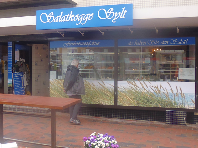
This is significantly less "expensive restaurant" and significantly more "cheap counter lunch" than what I expected, which has advantages and disadvantages. The obvious advantage is that it's naturally a lot cheaper. It's also a lot faster and probably safer than sitting in a restaurant too. However, instead of a local speciality or something, all we get is some shrimps sandwiches with cocktail sauce. Gotta hand it to them though, those shrimps really are delicious.

After filling our bellies like this, we continue south towards the one Geocache that is within walking distance. Along the way we pass by a bar that also offers drinks to any four-legged companion creatures ("Hunde Schlapp Schlapp" = "Doggie Slurp Slurp").

We also come across the big old grand-daddy of off road bikes. In fact, I think I've seen its like already once before, in Kyoto (see Book II ~ Chapter 20 ~ Kinky Kyoto). Unlike it's brother, however, this one actually has gears, and thus would probably make a pretty good mountain bike if there were any mountains within 200km of this place.

And I know we were looking for a type of crab here, but this is definitely not the sort of crab we were looking for.

One thing to know about Sylt is that as a tourist spot, it maintains as good deal of infrastructure just for the sake of tourists. As such, it is only fair that tourist have to pay a small Kurtaxe ("Spa Tax") to make use of it. If you do, you get a visitor's card that gives you access to some of aforementioned infrastructure, like say, the beaches of Westerland. As such, there are little checkpoints set up at each of the entrances to the beach. Fortunately, we received such visitor's cards as part of our booking, and this is the one time we should actually make use of them to get onto the beach.

The place where we decide to cross is also where I hope to find a Geocache. This takes us straight up across a rather mighty dune, meaning we actually have to climb stairs. Good thing I still remember how these things work.

Once on the top, we regrettable do not find the cache. However, with this being one of the highest spots around, we do get quite a panoramic view.

Down on the beach we can spot many exiting life forms, like the roofed wicker beach chair, a species of beach chair native to the north and east seas. During the summer month, it exists in a symbiotic relationship with homo sunbathis and is highly territorial, which each individual maintaining a very specific distance from its kin, resulting in a distinct pattern of distribution. For the rest of the year it usually hibernates on the beach or in nearby wooden or metal caves, often huddling close together against the cold. We seem to observe it in the brief transition period between its symbiotic summer relationship and hibernation, though there are also subspecies that remain on the beach all year long.

And then, we also come across a wild specimen of a type of sponge that has long since become indispensable in modern households. Known colloquially as the Glitzi Schwamm ("Sparkly Sponge"), I have thus far only seen harvested and dead specimens in supermarkets, so finding one out here in the wild is a truly profound moment for me. Take note how its yellow coloration serves to camouflage it against the sand so well that it has as of yet gone undetected by the industrious sponge harvesters of Sylt.

Knowing that this is probably the last time for quite some while that I'll be this close to the sea, I take some time to jsut stand on the beach and listen to the waves and wind. There's quite a breeze blowing today, which results in a nice display of waves, and I just barely avoid getting wet feet once or twice.
We continue back along the beach for some more time, and then cross over the dunes once again at a place where the dunes display a distinctive step-like pattern. At this point, by the way, we are pretty much looking straight down to the southern end of Sylt. You could straight walk down that beach for about 16km from here without encountering any noticeable bends or curves.

Having seen enough yellow for one day, we proceed through some green. Fortunately, I managed to pick out a route that first takes us through a nice little park (or maybe "shrub alley") would be a more fitting term)...

...and subsequently through a small city wood.

We also pass some roads with rather interesting names, such as the Jap-Peter-Hansen-Wai and the Twesk Wungen. As for what these mean, actually, your guess is as good as mine.

And then, we come across a sign indicating that Sylt - contrary to all appearances - seems to be unusually tectonically active and experience massive intra-island drift. When this sign was first planted here, for example, it apparently was 7km away from the centre of Westerland. However, due to massive tectonic subduction leading to the formation of aforementioned mighty Sylt highlands, a total of 6km of land have hence been eliminated, and today this sign is only 1km from the centre of Westerland. We better get going then, lest we get subducted too.

On our way back, we stop by a nearby supermarket to get ingredients for the pizza we intend to bake tonight, and then cross the train line one more time, this time on a level crossing and in the opposite direction, just to even things out.

Walking the remainder of the distance back to our stay place from there, we come across a very thematic Animal Crossing "Island Cruiser" trike, featuring the fitting slogan of "Bist du reif für die Insel?" ("Are you ripe for the island?")...

...and then, we are back at our apartment, where we bring in the laundry and prepare the pizza. This is our last evening here on Sylt, so let us now continue to...
The Retrospective
Of all the places we should stay in on our Germany tour, this was clearly the most upscale. We had a complete private apartment with very comfy beds, we had our own bathroom and a washing machine, even if we kinda did lack a dryer, it was close to the station and with good shopping options nearby, the temperature was good, the WiFi worked great, and we had a kitchen with a stove enabling me to bake Pizza, yay! However, this place was also the most expensive. And not just expensive expensive, but actually freakishly outlandish expensive expensive. One night in this place cost the two of us together over 100€, which makes our stay here on Sylt more expensive than the first three stays together! So, that's a major bummer on the overall score. But apart from the steep price, this place was actually really great.

On our last night here, we witness another nice sunset over the Skyline of Sylt...

...and then all that's left is...
The Road Ahead
Having been all the way to the north, there is now only south to go. We should still stay somewhat close to the sea, and yet also head inland for quite a bit. Our next destination is our third stopover location, and happens to be the smallest state of Germany, the Hanseatic City of Bremen. Once again, our trip to get there will have its own dedicated chapter, so make sure to watch out for the next chapter of the Travelling Fox Blog.
No comments:
Post a Comment