This jaunt - like so many others this year – was brought to you by the Green Shnolz (yup, it's still around, and not going anywhere anytime soon). Once again, an event was cancelled, and I found myself with a few vacation days, reasonably good weather, and the extreme need to get out and get some fresh air. This time around, the event was the Thalhäusl, which I also attended last year (see Book III ~ Chapter 8 ~ Project Petal Part 1 ~ To The Thalhäusl), and while last year this served at the inspiration for me beginning Project Petal, this time around its non-occurrence provides me with the perfect window to continue it in the form of…
Part 4 ~ The Petal of the Rooster

By now, I've been east and south, leaving north and west as major cardinal directions for me to explore. Fortunately, I have contacts in Augsburg (Wolf Petal) and Ingolstadt (Rat Petal) that might give me shelter. Unfortunately neither of them can host me on precisely these days, so my options shrink down to the petals of Rooster and Boar – at least if I want to maintain a relatively even distribution of petals. On a whim, I choose the Petal of the Rooster, since that will allow me to reach the Isar's next bigger sibling and parallel river, the Lech. And just like the Isar runs through Munich, the Lech runs reasonably close to the Swabian namesake of Munich, Schwabmünchen ("Swab Munich"). An Airbnb to host me is soon found, and before long I find myself on my way…
Across Three Rivers
11-Jun-2020Distance: 70km
Ascents: 200m
Duration: 8.75h
5/10🎁︎
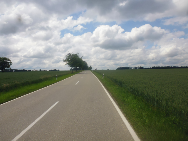
This time around, the weather should actually be kind of exciting. In fact, I did adjust my plans to start one day later than initially anticipated. Turns out that was a really good idea, for yesterday rain was pouring down like crazy, and the streets are still wet in the morning when I depart at 7:45 in the morning.

On my way to the Lech, I choose a route that takes me first just a little bit north, and then west roughly along the tracks of the S3 to Mammendorf ("Mammen Village"), getting close to the tracks, but never actually crossing them. Afterwards, I follow a regional railroad track all the way to Althegnenberg ("Old Tend-a-Mount"), and then cross over, gradually adjusting my aim further to the southwest until I reach the Lech and cross over. My goal for today, by the way, is not Schwabmünchen, but a nearby village by the name of Klosterlechfeld ("Monastery Lech Field") where I was able to find a reasonably-priced room for the nights.

Since my route is leading me west, it's not long before I cross my friendly neighbourhood stream – the Würm – which seems to be quite busy draining the waters supplied by the deluge of the days past. This is the first of the three notable rivers I should cross today, and each one to follow should be about three times as big as the last one.

Not much later, I reach the city boundary of Munich, and am off on my way into the countryside once again, under a threatening sky that reserves the right to pour down on me with unrelenting force at any minute.

However, I seem to be in luck, and after a bit of cycling through the fields, I reach the town of Eschenried ("Ash Reed") without getting hit by anything bigger than a few drops falling of the wet leaves of trees that I pass under.

A bit further down the road, I pass a place by the name of Graßlfing ("Small Grass Caught"), which features the very rare 70km/h speed limit…

…and a bit beyond that, I must have died of a very quick and painless death, for the next thing I see is a road sign pointing me to the Kingdom of Heaven ("Beim Himmelreich" = "At the Kingdom of Heaven").

Fortunately, the gatekeeper Marietta can be convinced of the great virtuousness of my noble quest, and awards me a second chance, sending me back on my journey, where I soon come across a herd of rather primal goats grazing on a field by the roadside.

Continuing onwards, I quickly reach the inevitable end of pavement…

…which fortunately is not quite as muddy as some other paths I should encounter on today's journey, allowing me to quickly clear it and make my way onto Snake Road, lazily winding its way through the fields.

The Olchinger See ("Olching Lake") marks the point where I leave my familiar territory and strike out onto uncharted grounds. The last time I came past here was during my ride to the Amper just a few months ago (see Book III ~ Final Chapter ~ New Home).

Incidentally, that is also where I come across yet another friendly reminder that the Green Shnolz is still up and about, giving to all who care to share.

After passing through Olching, I come through today's first segment of lush, green forest…

…closely followed by the Amper, which I cross by means of a road bridge near Neu-Esting ("New-Eton"). This is the second notable river of today's ride, three times the size of the Würm.

It's here in Neu-Esting that I come across the "Most Interesting Tree of the Ride", which looks like exactly the kind you might expect in sooky, haunted forests.

The next town I pass through is Gernlinden-Ost ("Glad Limetrees East")…

…and after that, I find myself cycling through plenty of fields, on most of which barley is surely approaching harvest-readiness.

There's also a lovely little lake nearby where myriads of frogs are just now in the process of mounting an concerto of croaks, attempting to hold their ground against the closer twittering of the birds.
Just a little bit away from that lake – almost within earshot of the frogs – I manage to (after a long search) find the clearly most cleverly disguised Geocache of this ride.

After that, more harmless field paths await…

…but it wasn't always like this, for I soon find myself on the Räuber Kneißl Gedenkpfad ("Robber Kneissl Memorial Path"). Matthias Kneißl was a local outlaw and social rebel during the time of the German Empire who gathered local fame for opposing the authorities. His life was a story of society failure, with him being effectively orphaned at age 16 when his father died and his mother was imprisioned for stealing at a church. With Matthias being the oldest of six children who had now been effectively left to the wolves by the authorities, I do not believe I need to elaborate how this ended up with a career in robbery. Today, a memorial path spanning several towns and villages between Munich and Augsburg, reminds of the tragic fate of this historic figure. You can easily recognize them by the "Helmet, Hat and Rifle" additions to the waysigns.

Subsequently, I realize that the easy part of the ride is now coming to an end, as I approach the edge of the Munich gravel plain, and the first little hills appear in front of me.

Ascending a hill on a field path is not necessarily fun…

…but once I'm on top, I am treated to a nice view, at the very least.

However, the path I have to follow across the hilltop might be called just a little bit overgrown.

Oh, and do you remember the strange triangular trench formations I saw on the fields during the Century Circadian Circuit (see Book III ~ Chapter 13 ~ Corona and the Century Circadian Circuit)? I should come across them again now, only this time around fully overgrown with crops. I still don't know what exactly is growing on them though. Agriculture is simply not my specialist field after all.

And then, I come across a town with a name that I have absolutely no idea how to translate. A very, very wild guess would be something like "Spear Sea's Cheek" (though according to my second cousin Andreas, it could also translate as "Yeast Cheek").

A hare crosses my way a bit further down the road, but the lepine is gone faster before I can ready my camera, hiding in the fields. However, it's just a little bit later that I come across a rabbit family exuberantly playing in the fields, allowing me to film them from a generous distance.
My major waypoint for crossing the hills is the Rotes Moos ("Red Moss"), by the way. Fortunately you can get there easily by keeping to the right of the red flowers.

However, the path is not without obstacles, as I should realize shortly after Holzmühl ("Wood Mill")…

…when I run into the prime candidate for "Roughest Path of the Year". Not only is it overgrown, narrow and steep, but beneath the grass lies a slippery and slick mud layer that you can either slip on or get stuck in, whatever you prefer. Really, you're only in trouble if you actually want to get through, but somehow I manage to do it anyway.

But after that, I finally manage to make it to Nannhofen ("Nann Farmyard"), which marks the eastern terminus of the MVV area. I grew up with the last station here being called "Nannhofen", but as nearby Mammendorf grew and Nannhofen stayed small, they eventually renamed it to "Mammendorf".

Interestingly, in the next village over – which would be Hattenhofen ("Had Farmyard") – I come across a brand-new old Roman milestone replica, measuring 31 miles from here to the city of Augsburg ("Eye's Castle"), which was founded by the Romans under the name of Augusta Vindelicum.

And then, I reach the Rotes Moos, which ironically is quite green around this time of the year. I can, however, guess that the name might come from the ground between the trees, which does have a kinda reddish tint.

It's a quite interesting landscape to be sure, which is the reason why I planned my route through here, though the greater structure becomes only apparent when viewed from above. Once, great parallel drainage channels were built to dry out the Rotes Moos, cut peat, and make the land arable. During the past decades, however, it was converted back into a more natural state, and today serves as a bio sanctuary. The drainage channels have become long, parallel lakes that can be seen from above. The identically oriented solar power plant right next to it makes for a nice finishing touch to green landscaping.

After that, I arrive at aforementioned Althegnenberg, where I have my usual lunch in the shadow of an idyllic little church built atop the eponymous little mount.

Following my lunch break, I soon cross over into the county of Aichach-Friedberg ("Oak Stream – Peace Mountain")…

…and following the zone change I also get sunnier weather. Looks like I won't be getting wet after all today.

Another interesting novelty in this zone are the Fish-o-Caches, of which I should find quite a few. Apparently, you need some sort of special geocache fishing rod to get to these. Shame on people who hide these for promoting wanton marketing strategies!

I also run into another hare, and this time I am fast enough to at the very least catch a picture of its white tail as it bounds for cover.

Schmiechen is another of these place for which I can't think of a translation. However, it does have a nice old church.

Anyway, by now the strenuous part of the ride is over, and although I'm not quite at my goal just yet, the going now gets a good deal easier.
Soon enough, I come across the Assisi Chapel, named after St. Francis of Assis, which features a very minimalistic bell tower.

From there, my next goal is – finally – the Lech. However, though I am close, the way to actually get there is not made any easier by detour-signs that don't actually specify a detour.

So I end up having to plot my own, slightly more adventurous route, taking me through a narrow forest path…

…and ejecting me right onto a lovely little construction site. Fortunately, today is a holiday, so I can just cut directly across it without anyone taking offense.

With that, I have now finally reached the third of the three milestone rivers of this ride - the Lech, easily three times the size of the Amper - and specifically the Lechstaustufe 20 ("Lech Barrage Dam 20"), which is one of a total of 26 barrage dams along the Lech. Interestingly, the numbering is a bit chaotic. The numbered dams skip the numbers 5, 16, 17, 24 and 25, 26 was never planned, but in addition there is one of the number 8a, as well as six unnumbered ones. And on top of the Lech also has 6 weirs, as well as three purely hydroelectric power plants without regulatory function. Of the 38 constructions built in total along the river, a total of 35 also feature power plants. Also, at the very least this one features something that I am going to simply label as "art".

Much more interesting than said "art", however, are the "Disney Whirlpools" that periodically form on the surface near the dam, thus illustrating why swimming in this peaceful-seeming lake might be a considerably bad idea.
Now I have almost reached my goal for today. All that's left now is following a lovely little forest path located between the Lech…

…and a lovely little military training area with danger to life and limb. Okay, so much for taking the shortcut through the forest.

But I manage to make my way to my goal the long way round too, entering Augsburg county…

…and arriving at the town of Klosterlechfeld…

…where I am quick to find the Airbnb that is going to serve as my base of operations for the next two nights.

Now then, after this long tour, let's have a look at…
The Place
Most importantly, this place features a nice little room for me to stay in – even if I have to be careful not to bump my head on the diagonal roof.

After that, the next most important thing is the kitchen, which I can use to prepare my own meals.

And not only does this place have free tea…

…it also has pets…

…as well as style.

Translated, these four signs read:
- Gotta go shopping! Only got light left in the fridge
- Chocolate does not solve problems! But neither does salad!
- Can't you think of anything other than food? >I don't understand the question…
- The kitchen looks like a pigsty! >Switched off the light. Now it's okay.

…which brings us to the very important question: Why does god need shoes?
Well, anyway, since today is a holiday, I made sure to bring some dinner with me in the form of a cup of tasty tasty Kitsune Udon which I now gratefully ingest after this long ride, blasphemously using a fork in place of chopsticks (and let me tell you, using the fork is actually harder, at least for the Inari-Age. Next time I'll try using two knifes).

Following that, I quickly hurry to bed to recover my strength. After all, tomorrow I'm going on…
The Lechtal Crusade
12-Jun-2020Distance: 41km
Ascents: 90m
Duration: 4.75h
3/4🎁︎
The following morning, I get up early to raid the next supermarket for supplies.

On account of, you know, me not even having anything for breakfast (why was it called "Air, Bed and Breakfast" again?), and since the supermarket also features a nice little bakery, I come out not only with supplies for lunch and dinner, but also a tasty Nusshörnchen ("Nut Hornlet") as well as a Bierstange ("Beer Rod"), which ironically does have nothing at all to do with the alcoholic malt beverage of the same name. Anyway, breakfast is saved, and I've even got something for tomorrow too.

After that, I'm ready to go out and seize the day, riding further east to Schwabmünchen, and on a whim even further west to the very edge of the Lechtal ("Lech Valley"), along a route that could probably have been planned better… in retrospective.

My ride today starts with a short trip through the idyllic backstreets of Klosterlechfeld itself…

…past the Kalvarienberg ("Calvary Mount"), a memorial to the passion of Christ…

…as well as Klosterlechfeld's eponymous and impressive abbey.

We've got the abbey, we've got the Lech, now all that's left is the fields, and here they come!

Interestingly, today the weather is clear enough that I can see all the way to the alps, even though even the closest peaks are still a good 70km away.

A bit further down the road, I realize that this particular ride should turn into a crusade of sorts as one of my Geocaches leads me right to this little wayside cross standing in the fields, and I realize it's one of a series of which I've targeted a few more, so more crosses are surely yet to come.

Anyway, before long I reach the penultimate goal of this entire petal, the town of Schwabmünchen…

…which sits not on the shore of the Lech, but rather on one of its sibling rivers – the Wertach ("Value Stream") – which joins the Lech about 30km downstream in Augsburg.

Originally, my plan was to follow the course of the Wertach upstream for bit…

…until I reach a little weir, and then cross back over again, but…

…seeing as how I'm now almost at the far side of the valley, fox goes "Want!", and before I know it I find myself cycling down the road to Schwabegg ("Swab Corner").

Schwabegg should mark the turning point of my ride today, for while it is an idyllic little village…

…it is also located on the flank of the Prügelberg ("Beatdown Mountain"), which is true to its name in the sense that trying to scale it using a bike would be the next best thing to corporal punishment. At a maximum incline of 18%, it's still only half as steep as Baldwin Street's 35% (see Book I ~ Chapter 14 ~ Out in Outram [Link=http://kiraresari.blogspot.com/2017/02/out-in-outram.html), but it still ranks way up there under "Very no".

Instead, I decide to take the road skirting the hillside to the south…

…which unexpectedly leads me just inside the Unterallgäu ("Lower Alp Area"). Another country for the book!

Anyway, after this little detour, I make my way back to the other side of the Wertach again, and as I cycle through the fields start to notice another detrimental effect of sunshine: Nourished by plenty of water and photons, the grasses release their pollen into the air, and unfortunately I belong to those people who are allergic to this sort of stuff. So I do my best to avoid sneezing, because I know that the first sneeze I succumb too will trigger a horrible series that will leave my throat and nose raw and itching. To others, these fields might be a beautiful sight to behold, but for me, especially those teeming with a certain variety of grass are, in effect, poison.

Sneezing or not, I manage to make my way to a little pond called Birkensee ("Birch Lake"). Apparently, much like the area surrounding Munich, the Lechtal was also extensively mined for gravel, leaving many abandoned yet beautiful quarry lakes in its wake. Incidentally, I also spot a pair of storks soaring high above here.

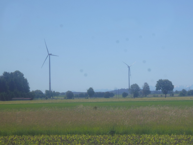
At the southernmost point of today's ride, I come across a pair of windmills, which are actually already standing in the next county again – the Ostallgäu ("East Alp Area").
Then, there's another relatively little-trodden field path, which I share only with horse and rider for once…

…as well as the next cross, which offers blissful shade by the grace of the trees. With the orbital photon blaster searing down from on high at full force today, the temperatures – while not extreme – are still considerable, and a shady spot to rest (and apply more sunscreen) is worth gold.

Incidentally, there's also another one of those dreadful Fish-O-Caches here. Thanks, but no thanks.

After that, the road leads me to a place with the melodious name of Langerringen ("Longer Wrestling")…

…and before long, I enter the county of Landsberg am Lech ("Land's Mountain at the Lech").

There, I come across a street that's apparently so important that it has not one, not two, but three street names. Japan could certainly learn a thing or two from this approach.

Not much later, I come across a crossroads bearing the final cross of today. However, since this one offers only a very limited amount of shade, I do not linger for long and continue sooner rather than later. After all, it just crossed my mind that both my skin and my stomach might be cross with me if I cross the boundary of the zenith hour before reaching my base of operations.

Fortunately, it's not far now. Pretty much all that's left is cycling past another beautifully turquoise quarry lake that's already halfway converted into a bathing lake…

…and then it's pretty much a straight road back to my home base.

As you may recall, I procured ingredients prior to my departure, and using them I cook up a savoury meal…

…which should last me for both lunch and dinner.

For the rest of the day, I take it easy, resting my legs for the journey home tomorrow. Of course, that means that I can still draw a nice thank-you message in the guestbook…

…as well as on the chalkboard.

But that's about it. The remainder of the day is dedicated to relaxing. After all, tomorrow should feature the long way home in the form of…
A Japanese Jaunt
13-Jun-2020Distance: 73km
Ascents: 300m
Duration: 9.25h
9/12🎁︎
The next morning, I get up at first light.

Before embarking on the way back, I devour the last remaining part of my shopping loot, which happens to take the shape of a Nussschnecke ("Nut Snail") and a Salami-Käsebretze ("Salami-Cheese Pretzel").

It's only 6:15 at the time of my departure. However, even at this early hour I do not manage to leave entirely undetected, for I run into the cat out there in the driveway, waiting.

And so, my ride back home begins by the time the sun is just barely out, and not a cloud in the sky. As of yet, it is still nice and cool, but I can already sense that this ride should not be quite as pleasant as my ride to get here. Dragon knows I should be right.

My route today should lead me first south along the Lech to the outskirts of Kaufering ("Buy Ring"), and then east towards Geltendorf ("Count for Village"). From there, I should follow the route of the S4 until Grafrath ("Count Advice"), and then make my way home past Gilching and across the Teufelsberg ("Devil's Mount").

However, this ride should have two main problems. One would be Radian, shining down with unrelenting force, but the much bigger problem should be the Poison Fields all along the way which – stimulated by past rain and present sun – release obnoxious amounts of pollen into the air.

Now, just from looking at it, it's of course impossible to tell since the pollen are far too small to be seen. But if I were to visualize it, the area would be looking something like this:

Although no clouds are in the sky just yet, it's already considerably more humid today, as becomes apparent by the fact that the alps can only be seen very faintly on the distant horizon.

Anyway, I manage to reach the outskirts of Kaufering without succumbing to a sneeze-attack…

After that, I cross back across the Lech again…

…and from there ride straight into the sunrise.

It is somewhere there that I run into the undisputed candidate for "Field Path of the Day" as I go in search of a Geocache.

But it should get more adventurous yet, for it is somewhere at the lost stream ("Am Verlorenen Bach" = "At the Lost Stream")…

…that I come across an equally lost forest path…

…which eventually takes me to the birthplace of the Holy Count Rasso, also known as Saint Rasso of Andechs. Among other things, he was the founder of Grafrath, which was actually named after him ("Graf" = "Count", and "Rasso" was sometimes also written as "Ratho").

It is on the following field that I end up having my first major sneeze attack for the day…

…which keeps on going until I manage to make it to the wonderfully sheltering, shading and pollen-free forest on the other side, and spend some time there drinking water and recuperating.

Eventually, I reach the village Schwabhausen ("Swab Homen") near Weil ("Because")…

…from where on out I should more or less follow the railroad tracks for quite some time.

Along the way, I come across a very interesting concept: A Mitfahrbank ("Tag Along Bench"). The concept appears to be something like organized hitchhiking in rural communities, a nice idea if you ask me, especially since there's a distinct lack of public transportation around these rural parts.

Following that, I arrive at the terminus of the S4, and with it the public transportation system of Munich: The town of Geltendorf…

…where I come across a Geocache that does not only feature a highly original casing…

…but also the best hint I have ever seen.

After that, I keep on following the train tracks, and even witness one of the very rare regional trains passing by (by contrast, in Japan, I would have seen at least half a dozen of these)…

…before making my way to Türkenfeld ("Turk Field").

There, I make a little detour to pass by a co-workers house. However, since it's only 10:00 yet, he is not yet awake, so I simply leave a card, and continue on my way.
Not much later, I come across the place with the most amazing name in the entire area, a village by the name of Pleitmannswang Peutenmühle ("Broke Man's Cheek Prey Mill").

By contrast, the following town of Kottgeisering ("Poop Goat Ring") seems almost tame…

…although that one is home to the famous Pension Klotz ("Guesthouse Chunk").

In the meantime, I have managed to get quite close to the Ammersee. Originally, I assumed that all its water flowed out through the Amper, so imagine my surprise when I find out it has a wholly separate outlet right here!

Anyway, by now I'm approaching the Amper, as I do I find a nature observation tower…

…from which I get a great panorama view on the surrounding Amperauen ("Amper Meadows").

I also realize that by now the Green Shnolz has become so infectious that it even started affecting stones.

Moving on, I continue to aforementioned Grafrath, where I cross the river on a rustic wooden bridge while boats filled with noisy teenagers pass below.

Following that, I boldly go where no bike has gone before…

And after many, many steps and a good number of horribly steep inclines, I arrive at an overgrown hilltop gazebo, where yet another cleverly disguised cache awaits.

Now, if getting up there was already tricky, getting back down again proves even more complicated. At first, thanks to a disastrous navigational error on my part, I somehow manage to end up right in the middle of a Poison Field in full bloom…

…and then I realize that by some strange sort of luck, I seem to have cycled all the way straight to Japan.

Naturally, I get to feel the consequences of crossing right through the Poison Field all too soon, and suffer from another horrible sneeze-attack even as I try to get as much distance as possible between myself and the source of my anguish. Fortunately, there's another forest up ahead that I can use to rehydrate and recover.

This forest should be the largest one I would pass through on this ride, and features many enigmatic structures, such as these things…

…as well as the mysterious invisible Celtic fortress, which has been completely overgrown and is only visible by means of signposts.

Also, the way to get back out of the forest again is just the tiniest bit bumpy.

However, eventually I manage to make my way back out of the woods and onto the fields again. Fortunately, this time around the fields are of the harmless sort. After today's experience with Poison Fields, I now know exactly which sort of fields trigger my allergy.

With that knowledge in mind, I pick a nice lunch spot next to a number of harmless fields to eat my traditional sandwich and Müsli bars, a nice and shady spot with bench and table that was apparently brought to me by the Pension Rosemarie in Gilching.

Further down the road, I come across another interesting Geocache. This one uses a simple pulley system to lower a canister that has been hidden up the tree to the ground. It's like those Fish-O-Caches, only good. =^,^=

Next up is the town of Puchheim ("Beech Home")…

…in the fields near which I come across a little chapel named Friedenskapelle ("Peace Chapel").

By now, I am already quite close to home. The last hurrah consists of the Teufelsberg, which is thankfully densely forested. It is also here that I come across riders for the second time during this petal.

However, it is only after that that I witness with shock how hundreds of humans are carelessly frolicking around in what can only be described as a market fair of sorts. It's the "We 💚 Corona" Hofreiter Fair! Green Shnolz Round 2, here we come!

By now, it's not far from home. All I have to do is cross the last bit of familiar terrain, and I'm back at the Fox Loft. By now, a few white clouds speckle the sky and occasionally offer a little bit of shade, but it doesn't look like it's going to rain anytime soon, so I can take my time for the last piece of the way.

And then, I arrive back at the Fox Loft, reasonably exhausted, but happy to have completed another part of Project Petal. By now, I've almost been in all the directions, with north being the only one left. Boar or Rat, which one should be next? Be sure to find out, in the next Interlude of the Travelling Fox Blog!
No comments:
Post a Comment