It all begins with Colin taking me into Hokitika, and picking up a hitch-hiker along the way: a girl from France who travels the country at her own pace. We pick up Leanne at the Westland Milk Products factory, and continue to the bus stop just outside the National Kiwi Centre, where we say our goodbyes.

The whole of this trip is split into three parts: First, the bus takes us from Hokitika to Punakaiki, where it stops to give us time to visit the famous Pancake Rocks and go see the Blowhole, then it continues through the Buller Gorge and all the way to Nelson. Here, I'll have to spend the night, before I can continue onwards to Takaka the following day.
Up the West Coast
The first part of the trip takes us straight along the coast.

And with "straight along", I mean zig-zagging around countless tiny bays, up and down, left and right, and roundabout. At one point, we have to go across a long one-way bridge, which is shared by motor vehicles and trains, and a short time later, we pass through the district capital of Greymouth. It's only after that that the road starts to get really crazy, behaving more erratically than a drunken driver who just stumbled out of a spin-dryer.
As we drive north, the climate gets visibly warmer, and palm trees eventually replace the coniferous evergreens. Eventually, after a two-hours drive, we arrive at Punakaiki, where the bus stops for half an hour to give us a chance to marvel at...
The Pancake Rocks and the Blowhole
The Pancake Rocks and the Blowhole are a local sightseeing spot just south of Punakaiki, and although I'm normally not the type to visit popular sightseeing spots, I make an exception this time since there's really nothing else to do around here, and the walk to the walkway to the rocks is quite serene.

Distinctive Nikau Palms can be found all over the place, and indeed, even though this place is not even a hundred kilometres north of Hokitika, the climate is already warm enough for me to leave my jacket in the bus - even with the clouds covering the sun.

It's only a short walk to the Pancake Rocks, and looking at them I can understand why this is a popular sightseeing spot. Unlike Fox Glacier, the Pancake Rocks are truly impressive, both on a micro and macro scale. From afar, the rock formations created by millions of years of erosion are absolutely astounding, and up close the unique pancake-pattern - which was created through an unique geothermal mechanism involving extreme pressure and the peculiar alternating combination of hard and soft sediments - is a wholly different aspect to marvel at.

The second attraction here is the Blowhole, which effectively is a rock chimney reaching down a good dozen meters all the way to the sea level, where the tide enters a small alcove through a tunnel in the rock. Normally, it just looks like an ordinary hole...

...but every so often, a particularly large wave rolls into the alcove, building up to greater and greater heights due to the tunnel's funneling effect, and eventually erupting into a fountain of water that splashes all the way up the chimney and showers the bystanders in a haze of sea spray.

After that, the walk continues down a flight of artisan stairs,

and returns back to the road, where the bus already awaits to take us to our next destination.
Passing into Tasman
The following leg of my trip should be by far the longest one (though not quite as extreme as the one from Queenstown to Fox Glacier). The route looks quite linear on the map, but in reality, the segment through the mountains (roughly between the two 6es, around Murchison) takes far longer than the rest of the trip combined.

Continuing up all the way to Westport, the road follows the Buller River into the Tasman Mountains, and through a long and winding gorge where the streets are at times narrow enough to give even a Smart the willies - yet our bus driver navigates them with skill and confidence. In fact, dashing over the narrow bridges and around tight curves like he does, I wouldn't terribly mind a little less confidence. Eventually, we pass over Lewis' Pass, and go down a series of switchbacks before entering the Wai-Iti Valley, which we follow all the way down to the Tasman Plains. From there it's not long until we finally reach Golden Bay, and with it, our destination of Nelson.
It's already quite late by the time we arrive there...

...so I waste no time checking into my room at the Aurora Backpackers...

...and go out to have dinner at my new favourite fast-food place. I'm going to miss Domino's when I return home.

As I return to the hostel, I take note of the peculiar bathroom arrangements...

...and soon after go to bed. It's been a long trip today, and I'll still have ample time to explore the city tomorrow before my bus departs, so I fall asleep without any regrets.
The Centre of New Zealand
I begin the next day with a rough idea of what I want to do, but no idea just how to do it. Since I don't know whether I'll be in Nelson for another night or longer in the future, I want to explore the city today, and since my bus only departs after 3pm, I do have the time to do so. However, checkout in my hostel is at 10am, so I have to carry all my luggage around.
Oh well, one step at a time. First off, I stop at a nice little café in the walking mall...

...and have a mushroom and steak pie for brunch. These pies are another thing I'm going to miss when leaving New Zealand.

Sitting in the café, I make good use of the free WiFi that comes with my purchase, and map out an exploration route for me to take. My first stop is definitely going to be the iSite, since I figure they might offer storage facilities for my luggage, so I can explore the rest of the city uninhibited.
On my way to the iSite, I walk by Anzac Park, which adequately reflects the subtropical climate this place enjoys...

...and continue to the iSite, where I can indeed drop off my bags for the day at a rate of only 4$ (which is less than I paid for my brunch). Subsequently, I walk down the length of Trafalgar Street...

...until I reach the great Christ Church, which stands prominently at the southern end of the road (not to be confused with Christchurch, which is another 200km south of here).

On my way to the botanic hill, I pass a car with a very creative (yet perfectly legal) licence plate...

...and also walk by the Queens Gardens.

Eventually, I arrive at the foot of botanic hill, where the entrance to the walkways is flanked by a pair of huge palm trees...

...and after I climb the idyllic walkways for a while...

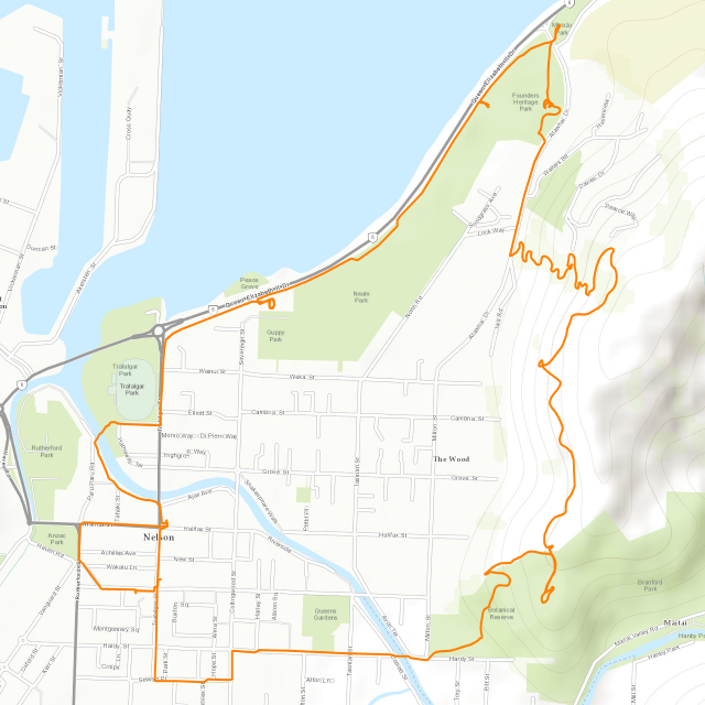
...I soon get a great aerial view of the city of Nelson below me (well, at least the part of it located in this particular valley).

There's something special about this hill though. Located on a rise near the summit, there's the geographical centre of New Zealand, which is conspicuously pointed out by a big stone monument.

After that, I walk along the Sir Stanley Whitehead Walkway, which leads me along the side of the mountain roughly along the tree line, and through pastures with sheep in them. Looking back over my shoulder, I can see the Centre of New Zealand Monument quite clearly in the distance.

As I approach the coast, the walkway leads me down the mountain via a dozen switchbacks on a forested slope...

...and subsequently leads me to the Miyazu Japanese Gardens.

From there, it's only a little ways further until I reach the coast, and find a sign which curiously is facing parallel to the cycle- and walkway. Maybe it addresses people riding runaway carts across the largely even field behind me?

...and ocean. But never mind that - its where you'll come to a halt eventually anyway. We also continue the New Zealand tradition of curious abstract art. I kindly dub this one "It that can not be pronounced."

The walk- and cycleway here also has an interesting approach of reminding people of traffic rules...

...and some time later, I pass by what could quite possibly be the worlds most pointless railroad bridge...

...which apparently connects directly to New Zealand's version of Hogwarts.

Eventually, I near the end of my circuit, as I reach the very northern end of Trafalgar Street, and pass under a very lovely flower-café.

Once again, I find caches in the most unlikely of places...

...as well as what appears to be the start of the Millicent Mudd Monument.

Finally, I cross the Maitai River, which sparkles in a beautiful turquoise colour...

...walk by a lady petting a bird in the bushes...

...as well as a dog sticking its head out of a window (or not)...

... before arriving back at the iSite...

...which is located across from the Nelson City Council, the building of which for some reason reminds me just a little bit of steampunk (even though it doesn't feature any unnecessarily moving parts).

It's here that I settle down for the next half hour while I wait for my bus to arrive, chatting a bit with a colourful girl from Great Britain, as well as a guy of unknown origin. The next leg of my trip to Takaka is just about to begin.
Ranging into Takaka
Since Takaka is a little bit off the beaten track, so it's not serviced by any of the major bus services, but rather a smaller, local coach line.

The route from Nelson to Takaka is only 100km long, but since it leads right across the Takaka Range, and thus has to climb from sea level to almost a thousand metres, it still takes a good two hours to complete.

The route first takes me back along the Golden Bay the same way I'Ve come last evening, and through the town of Richmond, before turning northwards across the Tasman Plains towards the Takaka Range. Climbing the mountains, the road eventually ends up in the highlands, before winding its way down into the Takaka Valley.
From where the bus drops me off, it's still a little walk until I arrive at my next place, but its nothing compared to the hike I had to take with my backpacks back in New Plymouth when the bus didn't come.

On the way I come across a sign that inspires me to come up with my own pictographic solutions...

...and a short time later I arrive at the gates of my next HelpX place...

...where I make myself comfortable in the dorm in the loft, wondering what this new place is going to hold in store for me.

No comments:
Post a Comment