Table of Contents
- Part 12 ~ The Petal of the Ox
- The Great Plains Offensive
- The Place
- Isar Inclusion
- The Main Event
- The Retrospective
- Ampertal Ascension
- The Road Ahead
This is it: The final complete petal that is still missing. And for this one, I have decided to really push myself to my limit with...
Part 12 ~ The Petal of the Ox
29-April-2024 - 1-May-2024
This time around, I actually have not one, not two, but a total of three destinations in mind: The first is Moosburg ("Moss Castle"), a place that I only know by name because it's printed on the Munich's public transport network maps as the next stop after Freising. The second is Landshut ("Country's Hat"), near which one of the last German nuclear power plants was operating (and I think my grandfather actually took me to visit it once as a little kid). And the last is Mainburg ("My Castle"), which is ironically not located anywhere near the river Main (that one is actually located over 150km to the north), and which marks the most remote bus stop in Munich's public transport network. In fact, it's close enough to Ingolstadt that I would have assumed it to be in Ingolstadt's public transport network, but alas... Oh, and if you want to see scary, check out the public transport options from Mainburg to Ingolstadt! By contrast, if you take the bike, you can cover that distance in less time and for free.
Anyway, the first part of this petal should take me to a place near Moosburg, which is the closest of the three places I have set my eye on (though still a good distance away). This ride should take me almost all the way to the northeasternmost tip of the Munich gravel plain, and since it barely features any ascents at all, how about we call it...
The Great Plains Offensive
29-April-2024Distance: 60.0km
Ascents: 70m
Duration: 7.25h
9/12🎁︎
My destination for this ride is Zustorf ("Closed Village"), a small village south of Moosburg where I found an affordable Airbnb to stay at. My route there takes me northeast and as I just mentioned takes me exclusively across the Munich gravel plain. Halfway through the ride, I cross over the Isar, and shortly thereafter I bracket the Munich airport together with the return trip of the Wolf Petal (see Book III ~ Chapter 11 ~ Project Petal Part 2 ~ The Ruprechtsberg Ride). In fact, since my destinations form a triangle this time around, the terminus of this ride is only a few kilometers outside of the Wolf Petal.

This ride marks a first among those of the Project Petal in that it really does not feature any notable ascents. Pretty much every other ride on the Project Petal featured at least some hills, but not this one. Here, it's mostly downhill all the way, with only a few small bumps along the way, such at the Berglwald ("Mountain Forest") near Oberschleißheim, as well as the banks of the Isar and the Dorfen ("Villaging") respectively.

As usual, I set out in the morning. Not too early this time around, though, since I know today's segment is relatively short, and I don't want to show up at the Aribnb before it is check-in time.

For starters, I cross over the nearby railroad switchyard, where construction for new tracks is presently ongoing.

Following that, I cycle parallel to the switchyard a bit, following the park on the northern embankment...

...and shortly thereafter, I'm already out on the countryside, where I spot a pair of geese sitting in a field.

Strictly speaking, I am still within the city boundaries of Munich, though, as I'm presently cycling through Feldmoching ("Field Liking"), where I come across a motorcycle shop with a very creative design element.

After that, it's back on the rural road again, and finally out of the city boundaries of Munich.

Crossing over the nearby Würmkanal ("Worm Channel"), I notice a trio of ducks - two males and one female - swimming across the stream, which makes me recall reading how apparently wild ducks display a particularly large ratio of male homosexual behavior, and how sometimes a female will attach herself to such a pair and attempt to interpose herself during mating. I wonder if that's the case with this unusual trio.

Anyway, shortly thereafter I come across the first forest path for the day...

...followed by a really questionable piece of bike routing that speaks of accidents both past and future.

By now, I have crossed over to the far side of the S1 tracks, if only just barely. From here on out, I should remain to the southeast of this particular train line, which is one of two heading towards the airport, the other being the S8.

Next, I enter the aforementioned Berglwald, where the track briefly starts getting just a little bit adventurous. Still nothing compared to what I witnessed on some other rides, though.

Before long, I'm out of these woods however, and my ride proceeds across significantly easier paths and roads taking my past fields freshly tilled or flowering with rapeseed.

Subsequently, I briefly graze the southernmost reaches of Lohhof ("Woods Farm"), where I coincidentally cycle right past the legendary Haus am Valentinspark ("House at the Valentine Park").

Moving on, I pass through the forest at the poultry farm ("Am Geflügelhof" = "At the Poultry Farm")...

...which takes me to the shore of my first lake for today: The Hollerner See ("Helling Lake").

It is near there that I come across a very cool geocache which takes the form of a puzzle box: Using various pieces of the apparatus, you have to figure out what you need to do in which order to get it to open up. That takes me a few minutes, but eventually the latch opens and the cache is mine to sign.

After that, I find myself back on the open fields soon enough. However, this time around I notice that the weather is clear enough that I can get a nice view of the Alps in the distance if I look south.

I also cycle through the southernmost street of Eching...

...where they did literally set it in stone that the nearby woods is a nature preserve.

From here on out, it's fields and dirt roads for quite a while as I circle around Neufahrn...

...where once again I get a great view of the Alps towards the south, this time around with Munich's two windmills in the foreground.

Not long after that, I cross over the Isar, making this the northernmost Isar bridge I've cycled across, but not for long.

On the other side of the river, I head north in search of a cache, which promptly results in me finding today's Field Path of the Day. In fact, this one is so challenging that it's not even an are-you-sure-this-is-a-way anymore, but more of a where's-a-will-there's-a-way. As such, I spend most of my time on this capricious way pushing (and occasionally even carrying) my bike rather than riding it.

However, the reward is well worth it: Not only do I find the geocache at the hidden pavilion...

...but the pavilion also turns out to be the ideal place for my lunch break. There I can sit, sheltered from the scorching rays of Radian, while enjoying a relaxing view of the nearby pond where ducks rest at the shore of a gravel bench.

After this tough little segment, you can bet your tail that I'm glad to see a proper road again once I get out of these particular woods.

Pretty much immediately after I make my way across the tracks of the aforementioned S8, which as you can probably guess means I'm getting close to the airport now.

It is also from here that I first spy the telltale huge chimney of the biomass power plant of Zolling ("Tollen"), which is a local landmark that I've often noted while cycling in this particular area, but haven't gone to the root of... yet.

Next, I pass through the town of Hallbergmoos ("Reverb Mountain Moss"), which is where I come across an orchard filled predominately with deer chilling in the shade of the trees. Also, chickens.

Leaving the herd behind me, I follow the run of the nearby Goldach ("Gold Stream") all the way down to the airport.

There, I choose to ignore a totally not suspicious character sitting next to the fence with a stepladder...

...and make my way east along the airport moat...

...passing a plane that is very likely no longer in service on a side field as I do.

Eventually, I come across the most grueling ascent of this ride: The southern vista hill!

Once I have painfully worked my way to the top, I take a moment to relax, watching the planes land and take off. Incidentally, right around now my best friend Robert was planning to fly to Greece. What are the odds he's on that very plane right now?
(Click here to view the video in a new tab if this website fails to display it)
With that, it's time to leave the airport behind and continue through the nearby village of Schwaig ("Hush")...

...where I unexpectedly come across another garden full of deer. This time both the garden and the herd are much smaller, but in exchange there's a few deer in here that are so pale that they're almost white.

This is also where I cross the aforementioned stream by the name of Dorfen, which incidentally has absolutely nothing to do with town of the same name. That one is located roughly 25km to the southeast straddling a stream named Isen (Iron), which unlike this Dorfen flows into the Inn and not the Isar.

By now, I am gradually approaching the edge of the Munich gravel plain, which means that the landscape starts getting slightly hilly, but nothing even close to aforementioned vista hill.

Just like on my return ride from Ruprechtsberg, I am now beneath the plane corridor, which means I got a few planes passing more or less directly overhead, which this plane company evidently foresaw and printed its web address on the belly of their plane.

A little bit further down the road, I reach the Isar channel coming from the Speichersee that some of my rides took me past and/or across, and find myself right at the site of an old hydroelectric plant.

I use the next bridge to cross over the channel...

...and then proceed to follow its run for almost the entire remainder of this ride for one reason: I want to include the entirety of the Isar - including this channel - in my territory all the way up to Landshut. And since the crossover point with the Wolf petal is only two bridges further down the channel from where I just crossed, all I need to do is keep to the right of the channel from here on out, and I'll accomplish just that.

Interestingly enough, the channel also bridges a number of natural streams running perpendicular to it, allowing them to pass beneath without impeding their natural run.

Eventually, I reach the bridge where I have to turn back north across the channel in order to reach Zustorf. However, there's a problem: Apparently, no one anticipated anyone cycling on the bank of the channel to want to cross over here, so there's no official way down here. Fortunately, there's still a definitely not official Where-There's-A-Will-There's-A-Way. However, since this one is only a very short segment down the embankment, it is in no danger of usurping the title of Field Path of the Day.

After making my way down the embankment, I can then safely cross the channel by means of the provided bridge. Looking east, I take note of the not-so-distant hills of THE BORDER marking the eastern end of the Munich gravel plain.

On the other side, I make a short stop at the shore of the Thenner Weiher ("Dann's Pond")...

...before crossing the last few flat fields that still separate me from Zustorf.

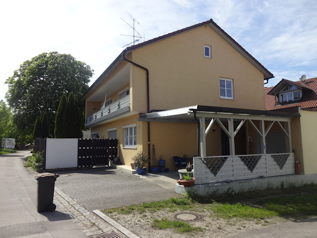
A few minutes later, I arrive in Zustorf, which is a medium-sized village with one major road, about a dozen small side roads, and maybe a hundred houses or so.

The Airbnb place I'm staying at is more or less in the middle of the village, read about a minute further away. It looks like a renovated old house, and a nice place to stay these next two nights.
And that's the way here covered. Next, let us get right on with...
The Place
This Airbnb turns out to be a co-living flat where I occupy one of four rooms on the floor. The room itself is nice and big...

...and also features two bottles of free mineral water, which is always a welcome sight.

The shared bathroom is just across the hall and features everything I need...

...as does the kitchen, except for basic cooking supplies such as salt and oil. Fortunately, Andy, one of my very temporary flat-mates is nice enough to let me use a bit of his.

My room also features a nice little balcony overlooking the garden and main road. Not that I should use it much, but I suppose it's still nice to have.

Much more importantly, there's a nice, laptop-friendly workspace where I can set up my trusty old Liete to help me keep track of my route.

Finally, outside on the pavement, there's a patch where apparently a cat was not willing to wait for the cement to dry, and left its permanent marks on the driveway.

So much for the place. Now, I still need to get some shopping done today, and there's still plenty of daylight left in the day, as well as pedal-power in me, the direct consequence of which is a shopping trip that is a good bit longer than strictly necessary, all for the sake of...
Isar Inclusion
29-April-2024Distance: 15.0km
Ascents: 50m
Duration: 1.5h
Remember how I said I wanted to include all of the Isar - counting the Isarkanal too - in my territory up until Landshut? Now, how does that coincide with me now being on the wrong side of the channel to do that? Well, here's what I'm gonna do: I'll cycle over past Langenpreising ("Long Pricen") and towards Pfrombach ("Bpious Stream") - where I plan to cross back over the channel tomorrow - and then double back south along THE BORDER until I reach Wartenberg ("Wait Mountain"), where there's a supermarket. After having done my shopping there, I'll head west, crossing over the Isarkanal by means of the same bridge as before, thus including that extra segment.

As a result of THE BORDER, this ride should feature significantly more challenging ascents than the ride to Zustorf from Munich, although in sum its still less. Specifically, once I cross over the Isarkanal, I have to cycle uphill for about 30m, and then there's a dip with a downhill segment immediately followed by an uphill segment taking me up even higher. Why can't the road just run roughly parallel to the isolines? =>,<=

Anyway, the way to Langenpreising leads across an open field, and much to my delight the road there even features a separate foot-and-bicycling path.

Before long I reach Langenpreising, where a sign cautions that left yields to right in the entire town. This is indeed a valuable piece of advice, because in most towns it's the rule that the central main road has right of way, so in here I actually have to watch if anything is coming from the side roads to the right.

Following Langenpreising, there's a bit of busy road with no bike road along which I don't dare to stop for pictures. Instead, I hurry on all the way until I reach the bridge across the Isarkanal, where incidentally I find another hydroelectric power plant past a bridge that is definitely not Monty Python proof.

After that, I take a sharp right and make my way up into the hills of Pfrombach, cycling past a field featuring the withered, prominently red stalks of last year's harvest. I wonder what was grown here.

Unexpectedly, it is there that I come across a house with the three Kanji 康氣福 painted on a corner in a decorative font. Meaning "Ease", "Spirit" and "Fortune" respectively, they don't combine into a valid phrase that I know of, so I assume the owner just painted them there as blessings of sort, conveying wishes for these three things, which are indeed good things to wish for.

Leaving Pfrombach behind, I follow the rim of THE BORDER by means of a field path that slopes generally uphill.

Incidentally, on account of the Isarkanal leading up to a drop of more than ten meters at the power plant, I actually have to cycle uphill for quite some distance before I am finally at level with the channel.

Eventually, I make my way to Wartenberg, where a supermarket is conveniently located just there at the main road.

After buying supplies for the next 30 hours, all I need to do is return back to Zustorf... which is actually easier said than done on account of heavy blocking construction at the Achilles junction of Wartenberg. Fortunately, there's a way for pedestrians to get through, which means I can pass as well by pushing my bike carefully past pits of fresh tar.

The upside of that is that the road on the far side is spectacularly quiet, to the point where I wouldn't even have needed the extra foot/bicycling path.

And beyond that, it's back across the Isar Channel and down Déjà vu lane back to the Airbnb. I could have taken a different path back, but since I'm carrying fresh minced meat without any cooling on a day that is kinda warm, I figure making a beeline home is the correct choice.

Back at the Airbnb, I proceed to the kitchen to prepare my dinner, and as I do so I notice a very angry looking chopping board looking back at me. Well, I sure would be angry too if people repeatedly worked me with sharp knives!

For dinner, I go with my by now long-standing tradition of having Naleiayafero on petal rides. Knowing that this will be the last time I cook this on one such ride (at least for the foreseeable future) actually makes me kind of nostalgic. The first time I made Naleiayafero on a petal ride was actually not until the Boar Petal (see Interlude ~ Project Petal Part 5 ~ The Tri-day Two-hundred Tour) - which at this point is still already three-and-a-half years in the past - and it has been my favored dinner for these rides ever since.

Anyway, as usual, I make enough to have a good portion for tonight, as well as another one for tomorrow, which I get to store in my room's private fridge (at this point it's quite obvious that this apartment is actually designed for more long-term stays and I'm just filling out a few days of vacancy while my host is looking for a new tenant).

And that's it for today. I still update my maps and then soon go to bed in order to be fresh and well-rested tomorrow for...
The Main Event
30-April-2024
As usual, I start the next day with some baked goods procured yesterday. Today, these take the shape of an Apfeltasche ("Apple Pocket") and a croissant...

...and then its out and on the road with the rising sun. After all, I've got a long way to cover today.

Distance: 100.0km
Ascents: 380m
Duration: 10.5h
6/12🎁︎
Today should feature my second-longest bike ride yet, and the longest of any multi-day bike tour, and the ascents are nothing to be trifled with either. In fact, that makes this the only petal where the Day 2 ride is longer than the other two. With that in mind, I took care to actually plan my route such as to take optimal advantage of the terrain: First, I cycle down the Isar valley to Landshut, staying just clear of THE BORDER. From Landshut, I head west and a little bit north into the hilly Holledau, but while doing so I follow the run of first the Pfettrach ("Phat Maw") and then the Further Bach ("Ford's Stream") for as long as possible, so instead of constant taxing ups and downs I actually get to enjoy a relatively gradual incline for most of the way until my ultimate destination of Mainburg. From there, I head south and a bit west to Moosburg, again sticking to valleys as much as possible, but since the Isartal and Mainburg belong to different watersheds, I have to crest the divide between the two both on the way there and back again. Finally, from Moosburg it's a relaxed ride back to the Airbnb, which is good because by that time I'm gonna be quite beat.

In terms of altitude, the ride starts out relatively tame, taking me mostly downhill all the way to Landshut with the exception of some small climbs where the road starts cutting into the hills as the Isar starts hugging THE BORDER. Then, after crossing over the Isar, there's first a bit of a climb to get out of the immediate Isar valley, and then a continuous climb as I first follow the Pfettrach until the town of Arth ("Khind"), and then the Further Bach up until Obermünchen ("Upper Monks"), where I finally reach the point where there's no way around the inevitable climb across the watershed to Mainburg. And past Mainburg, there's an even more brutal climb back over the watershed between the village of Tegernbach ("Tea Like Stream") and the hamlet of Pumpernudel ("Pumper Noodle"). Fortunately, that's the last considerable climb, and then it's down all the way until I reach the Amper, Moosburg and then again the Isar in quick succession.

But all in due time. For starters, I'm just cycling down the Isar valley, across the fields and into the sunrise.

As I cycle through Langenpreising again, I notice a little curiosity by the side of the road that I must have missed last time: The Gausthaus zum Unterwirt ("Inn at the Lower Host"), which befitting its name looks pretty run down.

It is only after crossing the Isarkanal near Pfrombach again that I enter new territory as I turn left instead of tight this time and enter the village of Aich ("Oak"). Incidentally, I also pass within a measly 3196km of Moscow at this point. Unfortunately, my schedule today is already rather tight, so I can't afford the detour.

At this point, I am cycling through a beautiful landscape with fields full of dandelion puffs...

...and before long, I find myself crossing over into the county of Landshut.

This also marks the beginning of the end for the Munich gravel plain, as THE BORDER draws ever closer to the Isar. At this point, there's still around 4km of flat land between the hills and the river, but that should soon enough dwindle down to nothing as I head further down the valley.

For now, I pass through the village of Weixerau ("Wheat Meadow"), from where I can see the nearby Schloss Kronwinkl ("Crown Angle Palace") in the nearby hills of THE BORDER.

After that, I reach the Echinger Stausee ("Cornery Reservoir Lake") - a veritable bird sanctuary the waterfront of which I'll follow the short distance down to the eponymous village of Eching ("Cornery"). Incidentally, this reservoir lake is supplied by the Isarkanal, which finally reunites with the Isar shortly before Landshut.

There, I am surprised to find that they have the same kind of recycling containers out here as we have in Munich, albeit considerably more colorful: You can see right away which containers are for white, green and brown glass respectively.

Following that, there's a last stretch of flat land only a few hundred meters wide...

...and then comes the part where the road and cycleway have to somehow share whatever little space there is between the hills and river. Also, no more space for farmland means that this is the first proper forest that I enter today.

Occasionally, there isn't even enough space for the cycleway next to the road, which always ends up with the cycleway climbing up to a higher isoline, to the point where it sometimes reaches the next higher road up the hillside. By the way, isn't that a very interesting place to park a trailer? One could surmise that someone actually wants to provoke an accident here.

Eventually, the cycleway gets fully absorbed into one of aforementioned parallel roads up the hillside...

...and a short time later, I find myself at the city border of Landshut, cycling beneath a railroad bridge that goes up into the southern hills.

Heading further east through the southern part of Landshut, I pass by an artfully designed house...

...before arriving in the innermost old city of Landshut, with its beautiful buildings and narrow alleys.

From there, I can also get a few glimpses of Landshut castle, the Burg Trausnitz ("Castle Fidelity Recess"), though actually going up there during this ride is a "very no" as this ride is pushing my limits as it is.

In fact, I am probably already pushing myself by choosing to cycle along the Landshuter Höhenwanderweg ("Land's Guard Heights Hiking Trail") instead of the busy main road. At this point it still feels like it's totally worth it, though.

I reach the easternmost point of my ride at the Rákóczi-spring, where the Hungarian national hero Ferenc Rákóczi II is said to have quenched his thirst in 1704 while retreating to France following a defeat at the hands of the Habsburger ("Castle Havers"). There's even a cute mini-Rákóczi sitting on one of the stone blocks here.

With that, the first side of today's triangle is complete. Now, I turn northwest, which almost immediately results in me crossing over the Große Isar ("Greater Isar") by means of the Adeneauer bridge, named after Konrad Adenauer, first chancellor of the modern Federal Republic of Germany.

But that's only half of the Isar, for you see, part of Landshut straddles a fluvial island known as Mitterwöhr ("Middle Guard"), which is what I'm currently cycling across. In fact, these two bridges mark the last opportunity to cross over the Isar for the next 6km or so.

This island is never any wider than half a kilometer, and so it isn't long before I pass over the Kleine Isar ("Lesser Isar") on the other side. Incidentally, looking upstream from there I can get a much better view of aforementioned Burg Trausnitz than from the old city.

On the far side of the Isar, I get to enjoy a few last kilometers of flat land while crossing over to the opposite edge of the Isar valley...

...and then, it's up into the Holledau in all its hilly glory.

Along my way up there, I come across a cemetery that is quite concise about enforcing its ban on bicycles.

Eventually, I reach a hilltop from where I get a good panorama view of Landshut...

...including another great view on the Burg Trausnitz on the opposing side of the valley, with the Saint Martin basilica in the foreground.

That's the last I should see of Landshut, for now I head off into the heart of the Holledau. Fortunately, after the initial ascent the terrain is relatively flat again. My road leads me continuously further up, but only at a very manageable gradient.

Along the way, I unexpectedly come across a very foxy place: The Rofu toy store, with "Rofu" ostensibly standing for "Rotfuchs" ("Red Fox").

I next pass through the village of Pfettrach, which carries the same name as the stream that I'm following. There, I need to search for a little bit until I find the slightly hidden bicycling path that will let me avoid the big road for the next kilometer or so.

That is incidentally exactly the distance to Arth, at which point I spy the first signpost pointing me towards Mainburg. Only 25km left, here we go!

With that, I am in the valley of the Further Bach now. The gradient starts to get a little bit steeper here, but overall its still relatively tame. However, there is no dedicated cycling path along the main road here, and there's just a few cars too many for me to find this bit relaxing.

Fortunately, I only have to deal with this up until I reach the eponymous town of Furth ("Ford")...

...where I can dodge the busy main road by taking a parallel back road that subsequently turns into a quiet country road.

Incidentally, this is the Further Bach that I'm following. Incredible to think that this little brook that is barely a few meters wide carved out this whole valley, which is almost a full kilometer in width.

Next, I befittingly find my first Geocache within the Holledau near a little village by the name of Schatzhofen ("Treasure Farming")...

...before passing one of the hops plantations that the Holledau is so famous for, with cows grazing on the pasture the next field over.

It is sometime after that that I get the feeling that I've left the business of the modern world behind in this place. There's a serenity to this particular area, with not much going on except a single tractor plowing the hilltop in the distance, and me cycling past a colorful church standing in the middle of a field of green. It's all very relaxing, and its moments like this that make long bike tours more than worth it for me.

However, the relaxing part of this ride is now about to come to an end as I pass first Niedermünchen ("Lower Monks") and soon thereafter arrive in Obermünchen.

This marks the beginning of the first set of harrowing ascents today, and while the gradient is only around 6% here, the fact that I've already cycled for roughly 50km by now means that I'm anything but freshly rested by this point.

Once I've reached the top of this divide, I find myself crossing over into the Landkreis Kelheim ("Throat Home County"), which I suppose makes sense, having the border roughly coincide with the watershed. From here on, all rivers run north directly into the Donau instead of taking the detour over the Isar.

With that, I am now at the top of the world for the first time today, looking down on rolling hills all around...

...and even able to spot a lone windmill standing somewhere in the distance past more hops fields. The first one in all of today!

Up here, I pass through several villages with resounding names such as Untergolzaberg ("Lower Bare Hill Mountain"), Obergolzaberg ("Upper Bare Hill Mountain"), Großgundertshausen ("Greater Hard Warrior's Homing"), Kleingundersthausen ("Lesser Hard Warrior's Homing"), as well as a hamlet with a name that goes straight to the point ("Spitz" = "Pointy").

I also come across a garden with flair: Here, a sign announces that the whole world is a madhouse, and this here is the headquarters. So, if you ever want to go and complain about literally anything, I suppose this is where you need to go. Or not, because another sign forbids trespassing.

Eventually, I reach the town of Sandelzhausen ("Sanding's Housing"), which is already directly adjunct to my destination of Mainburg.

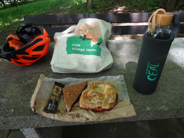
By now, I've been desperately looking out for a place to have my lunch break, but wasn't able to find a single bench in the shade. It is only here and now that I finally come across a park with some trees, and some benches and tables in the blissful shade of the trees. By now the temperatures are over 25°C, and with me pedaling my tails off some shade to cool down is quite welcome.

Incidentally, this rest spot also features a humorous reminder about taking your garbage back home with you. I'll make sure to respect that!

Anyway, lunch today consists of a Käsebretze, a Nussecke and a Müsli bar, a combination with lots of energy that will hopefully see me through the remaining 40 or so kilometers of today's trip. Oh yeah, and on a side note, the day trips of the petal rides are generally a bit easier than the trips there and back since I only take the absolute necessities with me on them as opposed to my full luggage, using my trusty souvenir bag from the Zao Kitsune Mura (see Book II ~ Chapter 5 ~ A Trip Together).
From there, I take the high road to Mainburg, cycling past one last hamlet by the name of Beslmühle ("Broom Mill")...

...and then I'm finally there: The city of Mainburg, hidden in the heart of the Holledau, and most remote outpost of the Munich public transport system.

Within Mainburg, I cross a little stream by the name of Abens ("In the evening"), and that although it is barely afternoon by now.

I also drop by the bus stop, which I have to say is considerably more fancy that what I expected the most remote bus stop to be like.

On my way south out of town, I come across another big road construction project. First in Wartenberg and then here now... I suppose late April must be a good time for this sort of stuff.

The last part of Mainburg that I pass is the district of Auhof ("Ow Farm"), which is an industrial/commercial district that stands out by its open love for solar panels, as becomes apparent not only by its solar totem pole, but also by how there's a whole warehouse not only covered but literally coated in solar panels on all sides that have even a faint chance of receiving some sunlight.

With that, two sides of today's great triangle are complete, which leaves only the third. And so, I head out south from Mainburg, which starts out quite pleasantly as I can cycle up the relatively flat valley of the Abens while also sticking to well-isolated and idyllic cycleways.

However, before long I have to leave that valley behind and head southeast, which results in me having another Déjà vu as I pass through another place called Furth. This one is only a little hamlet though.

Unexpectedly, my way still turns out to be concurrent with the route that the final bus line takes out here, as I can tell by another bus stop next to the hamlet of Kohlmühle ("Kale Mill").

After that, I'm already at the town of Tegernbach, and you remember what that means, right?

That's right! No more playing around! It's AAAAAAAAAA-time! In the green corner, we have the most grueling ascent of today's ride, featuring 50m of ascent on a distance of 500m, with peak gradients of up to 15%! In the orange corner we have one exhausted fox who at this point has already covered over 70km in a day, which is the distance that he normally covers in a day's petal ride. And now, with no further ado, ring clear aaaand... FIGHT!!!!!!!!!!

What follows thereafter can probably most adequately described as an ordeal, but in the end I manage to make it to the top, albeit with several breaks to catch my breath along the way. And at the top, the cute little and actually surprisingly modern hamlet of Pumpernudel awaits me, complete with a May pole bearing the names of the four families that live up here.

Speaking of surprises, there's also a golf parcour up here of all the places, because why wouldn't there be a golf parcour out here literally in the middle of nowhere? Well, then again I suppose you can always take the S1 to Freising and then the bus to get out here, so maybe it's not all that remote after all. Still... definitely unexpected.

One last climb awaits me - ironically near a hamlet called Grub ("Pit") - and then I have finally reached the highest point of this ride. At 513m of altitude, I am quite grateful that from here on out the rest of the ride should take me almost exclusively downhill. Also, there's a nice panorama to be enjoyed up here at the top of the world.

The steepest part of the downhill rush takes me to Hörgertshausen ("Strong General's Housing") in no time flat. There, I am thrilled to find the first sign pointing towards Moosburg. Also, there's an interesting old shed here called the Papierhüttn ("Paper Hut"), which features a fridge refurbished as a community library next to it

There's also a dedicated cycleway that starts at Hörgertshausen. However, it is not long before that one finds a rather abrupt end.

For the next few kilometers, the ride is smooth and simple as I follow the run of the valley down past places such as Doidorf ("People's Village"), Mauern ("Walls") and Niederndorf ("Lower Village")...

...but there's one last climb at Zieglberg ("Brick Mountain"), where I suppose they must have gotten the bricks for the walls of nearby Mauern.

Following that last climb, I ride down into the valley of the Amper, which I then subsequently cross...

...and after that, I finally reach my third and final destination for today: The city of Moosburg!

I find the streets of the old town to be quite festively decorated, ostensibly in preparation of tomorrow's Maifest ("May Festival")

In fact, it turns out that the festival is already in full swing a day early: There's a fully-fledged fair going on on the Viehmarktplatz ("Animal Market Square") of Moosburg, complete with stalls, shows and even some simple rides.

After leaving Moosburg, I cross back over the Isar again...

...and then turn right to follow a causeway that follows the run of the river upstream for a few kilometers before branching off towards the south.

With that, I am finally on the home stretch. It's not like I'm hurting or terribly exhausted, and yet I can clearly feel how I'm pushing my limits, my speed at this point being barely half what it was when I set out this morning.

The final landmark of today's trip is the Zustorfer Weiher ("Closed Village Pond"), which true to its name is closed off on all the sides by a dense barrier of trees...

...and then I'm finally back in Zustorf, after a long and taxing ride, and after another 200m or so I'm back at the doorstep of the Airbnb.

It is there, on the very last meters that tragedy strikes: Exhausted as I am, I drop my precious "The Chronicles of Ceal" drinking bottle (one of only ten in existence) as I unstrap my light luggage from my bike. Grievously, it does not survive the subsequent impact on the hard concrete pavement, ruining it beyond repair. Of course, this puts a massive bummer on my mood right there and then: Not only was this a potential limited edition collector's item, but I also had an emotional bond with that bottle. And yes, I've still got one intact spare back home (another being lightly damaged, and the rest gifted to friends and family), but that doesn't help me much when I am also in rather immediate need of a drinking bottle for my ride back home tomorrow. Fortunately, as you may recall, my host did kindly provide me with some bottles of free mineral water, so I commandeer one of those for my ride back home for tomorrow. And in memory of my trusty old Ceal bottle, I wrap it in the elastic cloth back that came with it.

Thus, this arduous day comes to a rather sad end, the sun setting as seen from the kitchen window...

...while I hungrily gulp down the remains of yesterday's dinner.

I go to bed after recording my lengthy ride today, apprehensive about how my legs will feel in the morning and how much of an ordeal tomorrow's ride will be. But before we get to that, let's briefly talk about...
The Retrospective
This time, I had my own room with a shared bathroom. The bed was comfy, the temperature good, the free WiFi worked nicely, and I had a kitchen in which to cook my dinner. Basic cooking supplies were not included, but Andy kindly helped me out. On the downside, the other people living here were a little bit too loud at night for my taste (and at the same time complained about me closing the door too loudly). The area was very nice, but also very remote, with no shopping options or stations anywhere nearby. With all that taken into account, the price that I paid to stay here was approximately three times as high as what I felt it was worth. By contrast, Miroku's place in Shizuoka cost us only half as much per night and person (see Book V ~ Chapter 26 ~ Shizuoka & Shimada Shenanigans) and the fantastic Ryokan Kosen in Nara with its super-tasty Japanese breakfast and cozy Ofuro was only slightly more expensive than this place (see Book V ~ Chapter 22 ~ Nara & Nearby). All things considered, this one ranks in the lower 25% of places I've stayed at.

With that out of the way, let us now get to the third and final leg of this petal, namely the...
Ampertal Ascension
1-May-2024The next day I get up precisely at sunrise. Fortunately, my legs are not quite as sore as I feared, but still sore enough that they'll make the ride home more difficult.

Breakfast consist of an Apfeltasche an a Zimtschnecke that I bought in a bakery all the way out in Mainburg yesterday, along with my supplies for today.

Before leaving, I draw up a little thank-you sketch for Andy, who was kind enough to share some of his kitchen supplies with me...

...as well as an apology note about the broken bottle for my host.

And then, I leave yet another empty room behind.
Empty? No, not quite. It is only as I try to saddle up on my trusty bike Jycily that I notice that something is missing... something that can't be seen from this angle.

My helmet! And I left the keys back in the room already! So there's nothing for it, and I have to ring the bell. Fortunately, despite it being only 7:30 on a holiday, my host is already up and lets me back into my room to pick up my helmet.

Ascents: 240m
Duration: 9.75h
6/12🎁︎
Today's ride features yet another objective of this ride, and that is including the entirety of the Amper in my territory. To do that I first head north for a bit, and then west upstream along the run of the Amper until Allershausen ("Everyone's Housing"), where the Amper turns south, and I with it. And from there it's south pretty much all the way back home.

Though today's ride should again feature a few hundred meters of ascents, it's still relatively tame compared to yesterday as there are no really bad climbs anywhere along the route. Sure, there are a few parts where it goes up for a bit, but these segments are all pretty short, and for the most part the climb is very gradual and tame. As a matter of fact, the highest point of this ride is indeed the Fox Loft itself.

Also, this Petal should result in me circumnavigating the Shelf, which is a curious, boomerang-shaped hill range north of Munich that is demarcated by the Munich gravel plane on one side and the Amper on the other. The clearly visible river valley that extends to the left from the tip of the Shelf belongs to the river Glonn, by the way - a major tributary of the Amper.

This time around, I start out by making my way across a field path next to a freshly-tilled potato field...

...which eventually leads me into a very narrow strip of woodlands and little ponds.

Once out of the woods, I unexpectedly run into rabbits. And not just one or two, but a whole warren of them, bounding all over the landscape, including across the shooting yard of an archery range. How daring!

And if it's not rabbits, it's deer! I'm not even an hour on the road today and I've already seen more wildlife than these whole last two days. I wonder if that's because of a combination of my early departure and today being a holiday. Or maybe this particular area has a ban on hunting? Who knows. Either way, I'm happy to see all these wild animals all over the place.

Oh yeah, and speaking of that, here's what looks like a pheasant. Unfortunately I couldn't get a closer look at it because it went and hid in the rapeseed field before I could zoom in or get closer.

Approaching more urban areas again, I pass by an interesting Mitfahrerhaltestelle ("ride-along stop"), which not only features an iconic symbol but also a thematic indicator for where the waiting person wants to go.

I very narrowly graze the outermost outskirts of Moosburg at this point, which are so remote that I'd describe them as an exclave, because there's no way to get to Moosburg proper without having to take a road that leads across fields on both sides.

Past that, I cross the Isar-Werkkanal ("Isar Works Channel"), which connects the Isar to the Isarkanal at this point by means of the Moosburger Stausee, so I assume it is used for fine-regulation or something.

Next, I cycle through fields of brightly blooming rapeseed...

...before finding myself in the village of Volkmannsdorferau ("People Man's Village's Meadow"), which not only features an unusual chapel fashioned from unplastered bright red bricks, but also chickens freely roaming the quiet streets.

By the way, maybe you have noticed that I only crossed the Amper once yesterday despite crossing the Isar twice, and the reason fir this ties in with another thing that I've come here for: You see, it is just past Moosburg that the Amper flows into the Isar, and - you probably guessed it - the confluence is right where I am now, between Volkmannsdorferau and Volkmannsdorf ("People Man's Village"). In fact, there's a very interesting bridge here which straddles the two shores and the very point of the last wedge separating the two rivers before they join. As such, you have this bridge that seems to cross a single river if you look to one side, but two separate rivers if you look the other way.

On the other side of the river(s), I am faced with one of today's few steep ascents, and while the gradient is tough on its own, fortunately the climb itself is relatively short, so I am able to get up there with relative ease.

This briefly puts me at the outskirts of the Holledau's rolling hills once again. However, today I have no intention of venturing further in.
After all, the main reason why I even got up here is because this is the only road that runs north of the Amper, and not crossing the Amper until Ottershausen ("Otter's Housing") is kinda my theme for today's ride. Incidentally, my ride up here should take me past the Schloss Isareck ("Isar Corner Palace"), a residence dating back to the 16th century, in which is still owned by a count and countess to this very day.

Next, I pass through the village of Wang ("Cheek")...

...where I find that the way that I had planned to ride is closed due to construction, so I am forced to take a detour over the nearby hamlet of Aselmühle ("Wodlouse Mill"). Fortunately that's only a very short detour.

Following that, I proceed along my planned route, which takes me across fields and through forests by means of quiet gravel paths.

However, not long thereafter, I come across something more troubling: A road sign indicating that the road I planned on taking is closed... and the next road over would either take me deeper up into the Holledau, or down and across the Amper, thus breaking the goal of my ride.

So, I choose to defy the sign and see if I can't somehow manage to break through whatever obstacle awaits. After all, as a bicyclist I figure I can always just push my bike across the fields past whatever obstacle awaits. And up until Pillhofen ("Pill Farming") I am not faced with anything that would impede on my progress.

Past that, however, we're back at "this time of the year seems to be auspicious for road construction", because there's a quite blocking bit of construction going on. And what's worse, this is at a bridge across a brook, so just pushing my bike across the fields is regrettably not an option.

However, what is an option is blatantly ignoring all the barriers and just walking across the construction site like a worker would, only with my bike in tow. And since today is a public holiday I don't even have to worry about anyone getting upset (except for the lady living there who yells at me for walking across her unkempt lawn on the last few meters).

With this obstacle now behind me, I've got a clear road ahead of me for the next few kilometers. Incidentally, from here I can see the huge chimney of the Kraftwerk Zolling ("Power Plant Tolling") up ahead, which I've last seen from near the airport. This is - in fact - my next landmark, for today is finally the day when I'll go to see this landmark from up close!

But that is then. First, I pass through the village of Niederambach ("Down at the Stream")...

...and make my way across the last corner of the Holledau in the fields north of Kirchamper ("Church Amper")...

...before turning onto a small forest path...

...that takes me almost all the way to the northern shore of the Amper.

It is there that I find myself on a promising candidate for today's field path of the day - a detour for a Geocache that I should thankfully find after all the trouble it was to get there.

You can imagine my relief when I finally come across a gravel road again. However, said relief turns out to be rather short-lived as the road steeply leads up a rise on the northern shore of the Amper on which the village of Inkofen ("Buy") is located.

On the plus side, it turns out to be a really lovely little village with a prominent dichromatic red-and-white church...

...next to which there's a vista from which I can get a nice view of the Ampertal ("Amper Valley"). Note that this is at the very eastern end of the Ledge, so the rise on the far side of the Ampertal is barely discernible as such. The valley should get much more recognizable as such the deeper I venture in.

Inkofen was the last major ascent for quite a while, which means from here on out I can proceed along the (thankfully not very busy) main road at a ground-eating pace... or at least I would if my legs were not still tired from yesterday. Even so, I am making good progress here though.

As such, it does not take long for me to reach the village of Haag ("Fenced Settlement"), which is the first place that I pass through that is celebrating the Maifest. In fact, that is something that surprised me, because I would have expected at least every second or third place to celebrate the Maifest today, not every sixth as the statistic currently stands.

Moving on from there, I am by now drawing ever closer to the Kraftwerk Zolling...

...but I am not quite there yet. First, I have to pas through the hamlet of Weihrinnen ("Bless Gullies"), and for once it's understandable why they don't have a Maifest there: For one the place barely has a dozen houses, and for another, the Maifest in Haag is, like, right next door.

Once past there, I have finally reached my milestone: The Kraftwerk Zolling! Originally finished in 1958, it used to be - and still partially is - a coal power plant. In fact, it currently is the highest-output coal power plant in all of Bavaria. However, this is presently changing: Not only was a new biomass block fueled by wood waste added in 2003, but the coal block is also scheduled for decommission at the end of may 2027. Incidentally, the trademark chimney of this power plant that can be seen for so far all around is a whopping 220 meters tall - that's only 71 meters shorter than the Olympiaturm in Munich!

What follows next is a long but relaxing ride west along the northern edge of the Ampertal. During that ride the meandering Amper sometimes comes all the way up to the road, and at other times it happily hugs the southern edge of the valley, which is over a kilometer south of the road I'm taking.

It is near Kirchdorf ("Church Village") that I espy the first windmill for today...

...and soon thereafter I pass through Nörting ("Northen"), which is not only where the crossover point with the Rat Petal is located (see Book V ~ Chapter 6 ~ Project Petal Part 7 ~ Into Ingolstadt)...

...but also where I unexpectedly run into a small rally of motortrikes of varying design.

It is also in near Nörting that I briefly head up into the hills again in search of a cache. I shouldn't find the cache, but instead I come across this highly unusual landform in the middle of the woods.

Past Nörting, I seen arrive in aforementioned Allershausen, where it's time for both me and the Amper to turn south.

It is also here that I come across a very inviting-sounding restaurant called the Fuchswirt ("Fox Host"). Unfortunately, it is closed today. Might be for the better, after all I am still carrying provisions of my own.

In addition, this is where I cross over the Glonn ("Shine"), a river that cuts straight through the High Hills, and which I've crossed over I think five times by now: Twice during the Boar Petal (see Interlude ~ Project Petal Part 5 ~ The Tri-day Two-hundred Tour), once during aforementioned Rat Petal, once during the Wolf Petal (see Book V ~ Chapter 15 ~ Project Petal Part 9 ~ Augsburg and Around), and once now. As a matter of fact, I think the Glonn has been entirely within my territory ever since the Wolf Petal.

After leaving Allershausen behind, I soon find myself following the run of the Amper Werkkanal, which powers a small hydroelectric plant over here.

Even though I already finished fully including the Amper in my territory with the crossover in Nörting, I am still unwilling to cross over even this side arm of the Amper at this point, and as such get creative with my pathfinding. A tricky endeavor that ends up with my cutting through a backyard and then following the causeway on this side of the channel.

By now, it's already well into the zenith hour, and I've been looking for a good place to have a lunch break at. However, up until now I've only come across benches that are located in the full light of the heavens.

It is only in the middle of Leonhardsbuch ("Leonardo's Book") that I finally find a nice and shady bus shelter...

...which I audaciously claim for my lunch break, netting me an unusually-shaped view. Lunch today consists of a Käsebretze, a Nussecke and a Müsliriegel, by the way.

After lunch, it's back on the road again. I still have 36km ahead of me, but at this point the area grows more and more familiar to me with each passing hour.

This is the point where the route briefly becomes a bit more hilly as the road crosses a knob near Hohenbercha ("High Mountain").

From up here, I can see the Bürger-Windrad Kammerberg ("Citizens' Windmill Chamber Mountain") just peeking over a hilltop. This is one of several renewable power plants that was realized by local citizen's initiatives in response to the local government slacking off in the modernization of the energy sector. Very commendable!

Following that knob, the Ampertal becomes wide enough on this side of the river that I can leave the main road behind in favor of more quiet but less well-paved side roads.

It is on one such field road that I come across a remarkably remote playground near Appercha ("Near the Heir's River"), standing right there in the middle of the fields, with the closest residential building being half a kilometer's walk away. Interesting design choice, but maybe the kids here just enjoy walks?

After that, my route takes me closer to the meandering Amper again, leading me through a landscape of half a dozen little ponds next to the river. I assume those were originally oxbow lakes of a cut-off meander that are still being supplied by little local brooks, and which subsequently drain into the Amper.
Beyond those lakes lies the town of Fahrenzhausen ("Driving's Housing"), and while I originally cycle past it, something makes me turn back: The sound of music.

Following the music I arrive at my second Maifest today, where the village girls are presently dancing around the May pole to the classical Bavarian music played by a traditional live village band. Very nostalgic! Also notice how the girls dance in such a fashion that the ribbons they're holding first get tangled up a little, and then get disentangled again. That sure must have taken some thought and practice to get just right!
(Click here to view the video in a new tab if this website fails to display it)
Afterwards I cycle along a road nicknamed the Solarstraße ("Solar Road") because it passes by a whole bunch of photovoltaic fields. Also, you can actually see all the way to one of the two windmills in the High Hills north of Dachau from here, and that should already be my third and final windmill sighting for today.

Following that, I embark on a somewhat more adventurous trail again...

...before finally crossing over the Amper (and a side channel) near Ottershausen, pretty much exactly 55km away from its mouth, and at the far southern end of the Shelf.

And it is here in Ottershausen that I also witness my third and final Maifest for today. I really expected to run into more of those.

Anyway, at this point, I am close enough to my home that I've done day trips to here and back, which still doesn't mean that I know the area inside out however. There's still much to discover here, such as this forest path which according to my map should eventually take me to Hackermoos ("Hacker Moss").

While in the forest, the path still falls into the category of "basically okay". However, as soon as I leave the woods it starts to grow more faint...

...getting more bumpy as the trees also retreat from the other side...

...and eventually turns all the way into today's winner of "Field Path of the Day" by virtue (or rather vice) of the ground beneath the innocent-looking grass being of such horrible consistency that I have no choice but to get off and push (note to my maps: you're fired).

Imagine my relief when I finally make it on a proper, paved and straight road again that quickly takes me the rest of the way to Hackermoos.

Past Hackermoos comes Badersfeld ("Bather's Field")...

...and beyond that lies another stretch of woodlands, in which another pheasant crosses my path.

In this area I cross over the Kalterbach ("Cold Stream")...

...before finding my way across a final set of fields... thankfully by means of a reasonably well-maintained gravel road (but definitely not as well-maintained as the gravel roads of New Zealand, mind you!).

Not long thereafter, I am already at the fringe of Karlsfeld ("Charles' Field"), where I cycle through a park running parallel to the Würmkanal which cannot be seen to the left for all the trees.

And then, I'm finally back in Munich once again.

From here on out, it truly is familiar terrain all the rest of the way. First, I have to cross through the Allacher Lohe ("All Stream's Wood")...

...before crossing over the Rangierbahnhof a few bridges west from the one I used on the way there.

Next up is the biotope, which despite being completely left to nature is remarkably tame...

...and then there's the good old Angerlohe, which admittedly features a few last challenges.

Once I'm out of these final woods, its only a few blocks through the lazy streets of Untermenzing, and then I'M safely back at the fox loft again.

However, that is not yet the end of my adventures today, for like so often, I am privy to a cat-astrophe upon entering my home.

Specifically, my cat sitter forgot to lock the cupboard door, which some cat (pointedly glances at Toledo) clearly took for an invitation to launch a raid upon the dry feed, tearing the bags to shreds.

Well, nothing to be done about it but to take out the duct tape and patch up the bags as good as possible...

...as well as put a cat raid scoreboard on the cupboard door, right beneath the warning sign. I wonder how long it will take until it hits 5.

Finally, there's one last mystery to solve: For some strange reason, a box of random books appeared in the middle of my living room. It eventually turns out that was a free give-away box that my cat sitter picked up at the curb and then forgot at my place. Oh well.

And with that, this petal is finally complete, which brings us to...
The Road Ahead
This was the final full petal in the project, which now only leaves the Broken Horse Petal to finally be fixed. However, before that, duty should unexpectedly carry me abroad once again. Want to know where and why? Then stay tuned for the next chapter of the Travelling Fox Blog! =^,^=