- Part 10 ~ The Petal of the Dragon
- Grey Grafing Grind
- The Place
- Choked Chiemsee Chance
- The Retrospective
- Mangy Mangfall Malaise
- The Road Ahead
My first Petal Ride in 2023 should also be the worst of the bunch. In
fact, this one is tightly interlinked with Ashley's abuse (see Foxy
Falseness). For starters, I did not actually plan to do this petal
in April because I am not stupid. The weather in April is about as stable
as spinning top on a tablet balanced on the horns of a bull standing on a
ball on a ship going down a waterfall, and as favorable to extended bike
trips as the sun is to ice cubes. I actually wanted to make this trip in
May, when the weather is a lot better in this part, but after
Ashley said she was going to visit me on the 20th of April and then stay
for a while, I preponed my plans to just before she was planning to visit.
Of course, with things going down the drain as they did, by the time I
departed on the date I was already pretty certain that I had been scammed
and she would not show up, and that I had moved my ride into unfavorable
weather conditions for nothing. And unfavorable they should be indeed, as
well as cold, with temperatures rarely exceeding 10°C on the
whole ride, thus making this Petal compete with the Broken Horse Petal
(see Book
V ~ Chapter 13 ~ Project Petal Part 8 ~ Alpine Abortion) for the
prize of "Worst Petal EVER". But anyway, that's enough whining from my
part, so lets just get this over with and talk about...
Part 10 ~ The Petal of the Dragon
17-April-2023 - 19-April-2023
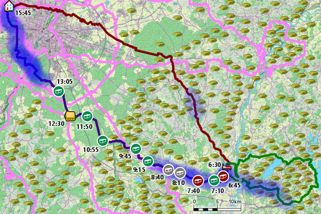
This time, my target is the city of Rosenheim ("Rose Home"), and beyond that, the Chiemsee ("Gill Lake"). Like Augsburg, Rosenheim is one of Munich's satellite cities, only in the complete opposite direction. Fortunately, Rosenheim is a few km closer to Munich, but since I need to add pretty much the entire diameter of Munich to that since I'm living on the exact opposite side, it is actually a little bit farther away from where I live. As usual, I have both given my ride there and back again a theme, which brings us straight to the...
Grey Grafing Grind
17-April-2023Distance: 80.0km
Ascents: 270m
Duration: 8.25h
7/12🎁︎
Actually, the ride there has two themes that coincide nicely with one another. For one, I want to cycle through the Ebersberger Forst ("Boar Mountain Forest"), and for another, I want to stay north and east of the train line going to Rosenheim. Adding up those two themes leaves me with a route that first takes me east through Munich, and then angles east-southeast towards the Ebersberger Forst. After exiting the forest, it then angles south-southeast all the way until Rosenheim.

Remarkably, the route should be reasonably flat despite crossing The Border (of the Munich Gravelplain). There is a short steep ascent right after crossing the Isar, but after that the climb towards The Border is very gentle, barely even noticeable. I cycle past Baldham - where my best friend Robert lives - and it is only when I reach the Ebersberger Forst sitting squat upon The Border that things get a little more rough... but not much. I narrowly miss the 600m mark just before leaving the forest, and then it's almost exclusively downhill all the way to Grafing ("Counten"). After that, there's a bit of uplands, and then a drop near Aßling ("Slateren"). One final small climb awaits near Ostermünchen ("Easter Munich"), and then it's downhill all the way until Rosenheim. It is actually interesting to note that Rosenheim lies, in fact, roughly 60m below Munich despite being further to the south and thus closer to the alps. Who would have guessed?

As for the weather... iiiit's... bleak. Gloomy from the moment I set out from home, and the forecast does not look much better. As a matter of fact, this whole ride's weather nicely reflects the whole spectrum of weather featured in "Against the Storm", an action city building game that I'm currently playing, where the weather conditions range from "Clearance" (little to no rain, and maybe even a bit of sunlight) over "Drizzle" (light rain) to "Storm" (heavy rain). I should experience all those three on this petal, but today, the weather should be mostly Clearance.

Taking the north bypass, I soon arrive at the park south of the Rangierbahnhof ("Switchyard")...

...and then follow the Moosacher Straße ("Moss Stream Street") for some time...

...before taking to the side roads in Milbertshofen ("Mill Castle's Farmyard"), where I unexpectedly happen upon quite a colorful dog.

Continuing from there, I soon cross the tracks of the tram line 23, which is notable for running not on a road in these parts, but rather through a linear park cutting a more or less continuous 1km-long swathe through the city.

A little bit further, and I arrive in the Englischer Garten ("English Garden")...

...where I cross the Isar by means of the St. Emmeram Bridge. Not for the first time, but there really aren't all that many nice bridges to cycle across this relatively big river.

At this part, the Isar is already split in two, so I subsequently also cross the Isarkanal ("Isar Channel"), which continues on to feed the Speichersee ("Reservoir Lake") that I've by now also circumcycled on both sides. Interestingly, I spot a party of a dozen dogs frolicking by the side of the channel some distance away.

On the other side of the Isar, I climb aforementioned steep slope, and then come out at the St. Emmeram tram station, which is the terminus of the tram lines 16 and 37, and also runs by my work place just a little bit south of here. The reason why both the bridge and the station are called St. Emmeram, by the way, is that there's a St. Emmeram chapel here, which in turn is a branch chapel of the St. Emmeram's Abbey in Regensburg ("Rain Castle").

I reach the border of the urban area at Johanneskirchen ("John's Churches")...

...and then I finally get out of the city after over an hour of being on the road already.

Quickly, I start turning onto less busy roads, the wetness of which stands testimony to the recent rainfalls, but for now, the Clearance still holds up.

Here, I follow an old, abandoned railway line - of which nowadays only the gravel bed remains - and as I do so I make my way across a candidate for today's Field Path of the Day... but not the winner.

Eventually, I make my way into the Landkreis Ebersberg ("Boar Mountain County")...

...the first place of which that I pass through is the village of Weissenfeld ("White Field"), which also marks the end of the convenient cycling path next to the road.

After that, a long, straight run across the east of the Munich Gravelplain awaits me...

...followed by the first forest of the ride.

However, this bit of woods does not yet belong to the Ebersberger Forst. Before I get there, I first have to pass through the village of Wolfesing ("Wolves Sing")...
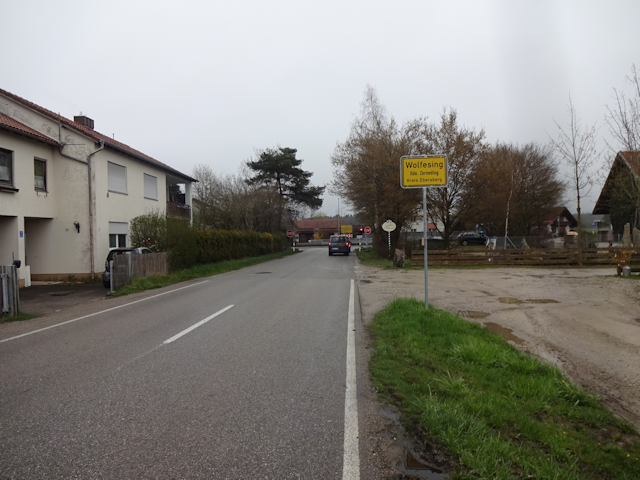
...where I pass by a paddock filled with not wolves, but goats.

Now on the other side of Wolfesing, that is the Ebersberger Forst! At roughly a 100km² with its eastern annex, it is definitely the biggest forest near Munich, though despite what Wikipedia says, it is not the biggest contiguous forest of Germany, no matter how you twist or turn it. Even if you define "contiguous" as "not interrupted by a major road" it falls short of other forests out there, because there's a major road cutting straight through the forest north to south, cutting it into two halves, the bigger one of which is only about 50km² big.

And then, if you start counting roads as interruptions, things start getting really icky because it's hard to tell where to stop, because the whole forest is segmented by a 400x400m grid of forest roads of different sizes. Personally, I would settle for counting a forest as contiguous so long as any swathes through the forest are narrow enough that a tree falling over one one side could reach the other side, and by that definition there are many bigger contiguous forests in all of Germany.

Anyway, into the forest, I follow a reasonable forest road through the as-of-yet mostly bare woods...

...which regrettably and ironically soon turns into today's winner of Field Path of the Day, on account of muddy and uneven ground that is so slippery that I sometimes even have to get off and push my bike, despite the gradient being mostly flat.

Now, you may wonder, what is more annoying than having to cover such a path once? Why, covering such a path twice of course, which happens because someone apparently thought it necessary to not only erect a fence at the end of that path, but also barricade what clearly was once and access gate. Good job!

So, I have little choice but to double down on that lovely path and look for another way. Fortunately, with the grid paths littering this forest, that means I can just try one row further to, say, the south, and as luck would have it there's even a diagonal horse path leading south outside of the grid, so I don't even have to go back "all the way" to the next north-south path.

For the moment, my good luck persists, and there, on the next path to the south, there's indeed a gate in the fence. A big, proper one, clearly made for cars, and the forest road here is open and wide enough that it might be another disputable divider for the above mentioned definition of "contiguous".

What follows then is a looooooooong straight road cutting through the forest with little opposition, and the most exciting thing that happens along that road is a few ups and downs. It's certainly tranquil and relaxing, though maybe a little too much so for my taste. I wouldn't mind a little bit of zig-zagging instead. Perfectly straight paths through the forest such like this one just feel... unnatural.

Eventually, I reach the Forsthaus Diana ("Forest House Diana"), named after the Roman goddess of the hunt, and near it find a reasonably dry bench and table that I use for my lunch break, consisting as usual of a sandwich and a Müsli bar.

After lunch, the straight forest road continues for yet a while...

...but before long gives way to a more natural, twisting and turning path that makes me feel much more at home in this forest.

Soon thereafter, I reach the other side of what I figure must be a roughly 30km² big wildlife enclosure. Fortunately, this time around I come out right in front of not only one but two gates to choose from.

On the other side of the gates awaits what I can only describe as a forest roller coaster: Steep descents on turning and twisting roads, and to top it off the path is not only bumpy and uneven, but also covered with slippery mud and/or wet leaves for added excitement. These circumstances severely limit the downhill speed that I dare to risk on this segment, but at the very least I manage to make it to the bottom of this slope without any accidents.

By now, I am close to the forest's edge, and looking south I can see the north end of the Egglburger See ("Corner Castle Lake"), which I last passed to the south of on the Petal of the Rabbit (see Hilly Havoc). That also means that I am close to the crossover point now, and about to leave my explored territory behind.

I continue cycling right alongside the forest's edge for a little longer, and am rewarded not only with some delightful ascents...

...but also the most skillfully crafted Geocache of this ride.

And then, I leave the forest behind. Still on the heights, I look to the south, towards Ebersberg and Grafing, and the sky is ever-threatening, though we still do have Clearance at this point.

Rushing down the hill, I pass the crossover point in no time, and then just very barely graze the town of Ebersberg, riding southwards through its very westernmost road.

Separating Ebersberg from Grafing, there's a lovely hilltop cycling route, which has the added bonus of me not having to cycle up to the hilltop, but being already on it on accounts of just coming down from the heights.

Not long afterwards, and I am already in the very heart of Grafing.

On the other side of Grafing, there's another modest climb, barely even noteworthy, if not for the fact that it is there that I pass the first sign pointing to today's destination of Rosenheim.

And it is also there that I espy today's one and only windmill. Alas, Bavaria really is the greatest... at avoiding renewable energies. °sigh°

A little bit further along the road, I happen upon a nice cycleway once again. Unfortunately, this one only takes me a short way until the village of Straußdorf ("Ostrich Village").

Contrary to it's name, though, I do not find any ostriches in there, only humble chickens are running around freely near the road.

Following Straußdorf, I take to the back-country roads for a bit, and that is when the looming Drizzle finally sets in. Fortunately, it does not last for too long, and is not too intense either, so all things considered weather-wise everything went reasonably well. Judging from the puddles, the brunt of the rain must have departed just prior to my arrival, and that is good. Though the temperatures are still a good deal too low for my taste.

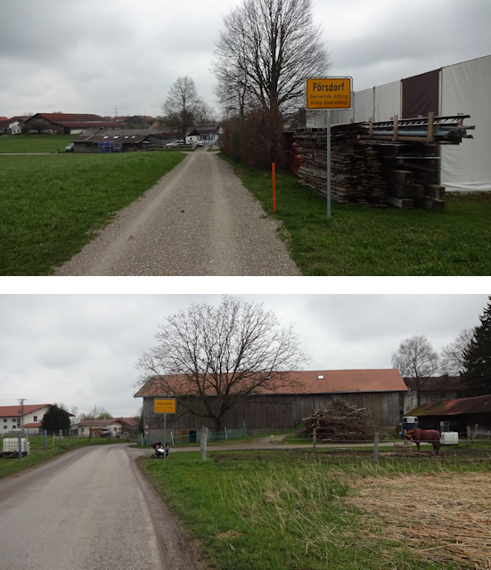
Up here, I pass such lovely sounding villages as Pörsdorf ("Pair Village") and Obstädt ("If City")...
...before enjoying the wheeee-ful descent down to Aßling along the steepest segment today, which also happens to be on a well-paved and straight road so I can just rush down the hill without worrying or braking. And to make matters even better, I do leave behind the Drizzle with the heights, and by the time I reach the bottom of the hill, the weather has improved to Clearance once again.

In Aßling, I then make my way past the dreaded Martermühle ("Torture Mill")...

...and as I make my way through the fields on the other side, I see two things that I have not seen yet on this entire ride: First a (reasonably) clear shadow, and then the sun! And even small shreds of blue skies are visible between the continuous cloud cover.

Now this weather is what I call a proper Clearance, with memories of rain, but the sun filtering through every now and then, and thankfully it should remain as such for the rest of the ride (though the air should remain regrettably cold still). Which, in fact, should not be for all that long, for by now I have already covered roughly three quarters of today's ride, and am presently cycling through the hamlet of Holzen ("Wooding").

Even with Radian out, however, the recent rains still stifle me, as many paths, such as this one by the forest's edge, are still covered in mud and thus impede on my progress.

Cycling through the back-country here, I come across yet another stream called Moosach and follow it between two forested hills...

...before finally making it to the town of Ostermünchen, which is right next to the railway line and even has its own station. This should mark my closest approach to the line of this entire ride. Also, with this I have now offocially crossed over into the county of Rosenheim.

Following Ostermünchen, I am on the victory road. From here on, there are no more detours, Geocaches or even navigation necessary as I pretty much just follow the curving road "straight" to Rosenheim. The road is not at all busy and mostly goes downhill, so this makes for a very relaxing finale. Even better, though, I can actually very faintly see the still snow-covered flanks of the alps on the horizon (the peaks being covered in clouds).

Along the way, I pass through the villages of Tattenhausen ("Deed Housing") and Thonbichl ("Clay Stream")...

...getting an even better view of the snow-covered mountaintops in the distance along the way. Did I mention it's still cold?

Moving on from there, I pass by a very interesting house that has a zipper on it...

...before cycling through Deutelhausen ("Pointing Housing"), which is the very last village before I finally reach Rosenheim.

Approaching the city, I pass over what is clearly the end of a state road... but not for long. Construction to extend it as a bypass around Rosenheim is apparently in progress, and that's great, only I wish that they'd direct their efforts into building renewable energies and railway infrastructure instead of more roads.

A few minutes later, I reach the outskirts of Rosenheim...

...and as I just so happened to find a nice Airbnb on this side of the city, it is only a few hundred meters from the city border to my stay place for these next two nights.

Check in is quick and uncomplicated, and with that, I have finished the first segment of this petal. The others should not be so nice, but that's a tale for later. Before we get to that, let me tell you about...
The Place
This time around, I am staying in a big, rustic farmhouse, where my host rents out a room and his elderly mother tells me that this house dates back until the time of Napoleon, and looking at it I can easily believe that.

"Rustic" also fits my room to an "i", and honestly, I am perfectly fine with that. No lavish luxury, just a cozy little den for a modest little fox such as myself. I feel at home here right away.

The room even comes with a little balcony overlooking not only the courtyard...

...but also the mountains in the distance, to which the weather has by now cleared a remarkably good view. If only tomorrow's weather could be this nice (spoiler: it won't be).

This place also features a cozy common room with a kitchen that I can use...

...as well as a bathroom with an actually usable shower, unlike the last place I've been to.

My room, by the way, also has the most minimalist laptop-friendly workspace that I've ever seen. Basically, it's just a board on a pair of props, and yet it does it's job just as well as any expensive desk, and that's really all I need.

Oh, and here comes catty company, because what kind of farmyard would be complete without one of these. Not a scaredy-cat at all, this friendly feline would regularly keep me company during my stair here. How cute.

On top of that all, this place has some nice flair, such as with this magnetic keyboard...

...or the meme-postcards hanging around, some of which very accurately is how I feel these days. Here's what they say, clockwise from the top left:
- I've got enough sex! Life fucks me every day
- Super simple smoothie recipe: 150g bananas; 100g spinach; one lime; Dunk it all. Open wine. Done.
- 🚽, how about you?
- Is that edible, or is it vegan?

They also have a loooong Bavarian Alps panorama map, on which I can trace my route during the Broken Horse Petal. Here's hoping that at least this ride won't see a debacle like that happening.

Shopping options are also very conveniently nearby, only about 5 STEPs away, and take the form of a REWE with a bakery conveniently located inside.

One short shopping trip later, I am all set for whipping up my traditional cycling tour dinner, a delightful plate of Naleiayafero. My host even lets me use some of their death peppers for an added kick in this cold.

And that's it for today, and I have to say that this place is clearly the best part of this entire petal, for tomorrow I should suffer the...
Choked Chiemsee Chance
18-April-2023
I start the next day with a breakfast consisting of some tea, a cheese-Semmel, and a... Chili Pretzel.Unusual, but definitely great for these temperatures.

Also, company, and unlike Jamie and Toledo, this one has absolutely no qualms about getting on my lap and trying to pilfer my Semmel from there. Good thing I already have some experience about how to keep felines like that at bay (see Book 1 ~ Chapter 23 ~ The Critters of Carterton).

Now, today's ride is scheduled to take me to the nearby Chiemsee, which is also known as the Bavarian Sea, for with an area of almost 80km², it is the largest body of water contained exclusively within Bavaria. This could be a fantastic ride with wonderful views of both the Alps and the Chiemsee, but... unfortunately, the weather starts out as Drizzle, and whereas I could nicely see the Alps from my balcony yesterday afternoon, all I see today is grey.

Stepping out into the light rain, I find that the cat has left me a gift at the doorstep...

...and then I am off, out into the Drizzle, hoping that it will get somewhat better over the course of the day.

Ascents: 590m
Duration: 9.00h
7/11 (+1 passed)🎁︎
I had briefly considered going all the way around the Chiemsee with this ride, but after crunching the numbers I quickly arrived at the conclusion that this would ad so much more distance to the ride that it would beat the Century Circadian Circuit (see Book III ~ Chapter 13 ~ Corona and the Century Circadian Circuit), and since I have a long ride ahead of myself tomorrow too, that is definitely out of the question. Instead, I aim for reaching the southwestern corner of the Chiemsee, then cycling up the west shore to the northwestern corner, and then back again. As a pleasant side effect, in doing so I should also encircle the entirety of the significantly smaller Simssee ("Ledge Lake"), which I recall seeing from above when returning from the Philippines (see Book V ~ Chapter 12 ~ The Singapore Sprint ~ Heading Home).

As for the height profile of today's ride... I could elaborate on that... but instead I think I'm just gonna scream.


Anyway, that Alpine anathema is yet a good ways off, and at first I have to cross through Rosenheim. Doing so, I note with a bit of curiosity that they seem to use the same system of recycling islands as Munich, only with bigger openings to their containers. This is by no means a certain thing, because wide parts of Germany use a different system, where all recyclable materials are put into either a yellow trash bag or a yellow trash can. So far, I only knew that Munich was the exception, but apparently Rosenheim is too.

Incidentally, I am still east of the railway line, and although I should come close once again - I pass just to the left of the railway dam - I still should not cross it today. At least not the one continuing onwards to Kufstein. Like most cities, Rosenheim is a crossroads for railway lines, and I should cross the eastbound line headed for the Chiemsee twice on today's ride.

After the initial sweep across the railway line, I then make a beeline through Rosenheim by means of the Prinzregentenstraße ("Prince Regent Road"), Rosenheim's biggest thoroughfare... at least for part of its length. Here's a less busy segment just before the state road joins it.

Following that road, I pass by the very Turkish-sounding Görgülü-supermarket, which come to think of it does not actually look like a supermarket at all, though the EDEKA-Sign clearly brands it as part of Germany's biggest chain of supermarkets.

And then, just a little bit further, I have to beware, because as it turns out, there are volcanoes in the engine shed of Rosenheim right around this time!

Moving on past that spectacular sight, I soon cross the Mangfall, which is one of the major landmarks in this petal, but more about that later.

Following that, I move through the corner of Rosenheim that is wedged between the Mangfall and the Inn...

...before crossing over said river on a rather high bridge.

From there, I have to go zig-zag a bit until I am back on my intended course again, and as I do, I pass by an arrangement of angular buildings known as the Landlmühle ("Country Mill"). As far as I can gather, that's an eco-friendly association farming green, local produce in this area.

It is also here that I first encounter the river Sims ("Ledge"), which flows from the southeastern tip of the Simssee into the Inn not far from here. In fact, the mighty bridge that I used to cross over the Inn also crossed over the Sims... and a third stream known as the Rohrdorfer Achen ("Pipe Village Stream") for good measure too.

And then, there's a bit more zig-zagging as I read the lay of the land here spectacularly wrong. On the plus side, this leads me past some interesting riverside locales such as a fluvial T-intersection and rather idyllic riverscapes...

...but on the minus side, it's still drizzle, and that turns one field path that I have to cross into a slippery mud trail that, though flat, is still absolutely impossible to cross while riding my bike, because my tires get absolutely zero traction. So I have to get off and push my bike here, earning this path the award for Field Path of the Day for this day.

Eventually, I get back on a properly paved round again, and I have to point out again how satisfying it is to be finally able to move at a decent speed and with little effort after trudging through muddy paths where the going was both slow and strenuous.

By now, I am obviously outside of Rosenheim already, and the next place that I pass through is the village of Niedermoosen ("Lower Mossing").

This place marks the border of the Inn plain, and from here on out, things get a bit more bumpy, though the worst part is only to come a little bit later.

Specifically not after the town of Riedering ("Reeds Ring"), which regrettably is literally the next town over.

And that is the start of the great and harrowing ascent for today. From 480m in Riedering to 640m in Söllhuben ("Should Heaving"), that is over 150m in one go, and for a distance of roughly 4.5km without any descents in between. Granted, the gradient is not very steep all the while, ranging between 2% and 5% for the most part, but such a climb is still a test of endurance for me, and I have to stop and catch my breath several times on the way up. On the plus side, however, the Drizzle at least cools me down nicely, so overheating is not a problem.

Well, at least I get a lovely view of the Alps from up here... or at least I would if it wasn't Drizzle! With those blasted clouds, the visibility is down to roughly 4km, and I can't even see down into the valley where the A8 highway runs, much less to the majestic peaks on the far side of said valley, the closest of which are barely 8km away!

But anyway, after roughly half an hour (which feels like at least two hours to me) of cycling up the slope, I finally arrive in the hilltop village of Söllhuben...

...where I promptly decide to also climb the last few meters to the peak on the Söllhubner Feld ("Should Heaving Field"), which is located at an altitude of 654m.

Once again, this would surely be a great place for a view, but, well, you know. Drizzle.

Oh well, at the least, what follows now is a relatively pleasant part of the ride, with the road going downhill for a while.

Also, I pass by a house with a mural so vivid and artistic that it won a price for it. Unfortunately, I can't get a level shot of it on account of someone having parked their car squat in front of it, and I still haven't gotten around to equipping Jycily with a sonic cutter.

My downhill ride ends in the town of Frasdorf ("Grub Village"), which is also where I pass under the A8 highway, first once, and then back again on the eastern end of the town.

What follows thereafter is an alternation of downs and ups, but none quite as grueling as the climb up to Söllhuben.

In these parts, there's a number of little curiosities to be found, such as a farmhouse that is clearly missing a bit of a ramp...

...as well as the legendary Hare-and-Wallaby-enclosure of Umratshausen ("Around Council Housing"). Of all the animals that I've expected to meet on my ride today, I have to say that wallabies were considerably far down the list, shortly before most marine life and laser-raptors.

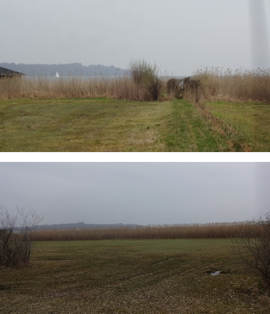
From there, it's only a little bit further until the absolute peak of today's ride, a height just before the town of Hittenkirchen ("Clearing Churches"). Located at an altitude of 650m, it is from here that one can get an absolutely fantastic view of the Chiemsee... on clear days, that is. With the weather still being drizzle, I can just barely make out the water and the shore of the Herreninsel ("Gentlemen's Island") on the near shore. For the record, the lake goes on for roughly five times that distance beyond that.

But gloomy weather or not, at the very least from here I have a nice downhill ride, cashing in most of the altitude that I worked so hard to attain. And while it took me half an hour to climb the 150m on one side, now I cover 125m downhill within the space of just over 5 minutes.

At the bottom, I quickly reach the outskirts of Prien, which is one of those simple yet obscure place names where I have absolutely no idea what it might mean. I know it is also the name of a river in the area, but that still doesn't tell us what the name actually means. If you have any idea then be sure to let me know.

Anyway, not long thereafter, I get as close to the Chiemsee as roads and paths will take me at this point, though roughly a hundred meters of littoral meadows still separate me from the shore.
Cycling parallel to the shore alongside a not exactly busy road, I come by a sign reminding car drivers to keep a distance of 1.5m if passing bicyclists such as myself inside cities, and 2m outside of cities. In practice, they usually get much closer, so here's an idea: If you hold a short sword with your arm outstretched, then your reach is something around 130cm, and with a long sword it's around 160m. So if you go cycling and are annoyed at cars passing by to close, just keep a pair of swords on hand and remember: If you can hit them, then they were officially to close. By extension that also means that if you can ever touch a car with your hand outstretched, then it is definitely too close!

A little further on, there's a Mitfahrbank ("Ride-Along Bench"). I really keep seeing those all over the place, and while I dig the concept, I also have to note that so far, I have never seen a person sitting on such a bench, indicating that either they work really well... or really bad. Me being a Flirial, I'd give people rides every day, only my desire to actually own a car is about as big as my desire to own a nuclear power plant. And then, there's always the issue of trust and many humans being jerks further complicating things.

But anyway, I also cycle past a neat tree-climbing with a lovely lake-view...

...and a little ways from there, I finally get all the way to the shore of the Chiemsee myself at the promenade of Prien.

I continue cycling further northwards along the western shore of the Chiemsee, this following a little path through the woodlands near the shore...

...until I eventually reach the Fischhütte Reiter ("Fish Hut Rider"), and with it the first dry spot in ages. Though Drizzle has since turned to Clearance, all potential resting spots up until now have been wet and drenched by the rainfall, so finally finding a roofed place like this is truly a blessing.

With no one around to take offense, I simply sit down at one of the tables and eat my lunch, which today takes the form of a Nussschnecke and a Schokocroissant, plus a humble Müsli bar. And even if someone had been around, Bavarian rules say that in a Biergarten ("Beer Garden") such as this you are allowed to eat your own food so long as you order a drink, so at worst I could have simply ordered some lemonade and be done with it. As it is, I get to finish my lunch in the dry and with a bit of a view of the lake in the distance without any disturbances.

After recharging my batteries, I soon come across a device where E-Bikes can recharge their batteries. Unlike those charging stations where you directly plug in your bike, this one takes the shape of a cupboard of sorts, featuring six compartments into which you can put your bike's battery for charging. Interesting.

Following that, I cycle along another little shore path, this time pretty close to the water...

...and then, it is time to say goodbye to the Chiemsee as I pass its northeastern corner near Riemsting, which is another of those place names that I'm afraid I'll have to take a rain-check on. Seem to be quite a few of them here on the shore of the Chiemsee.

After that, the blissfully flat part of this ride comes to an end as I scale the ridge separating the Chiemsee from the Simssee, for you see, the two belong to different local watershed systems: While the Simssee drains into the Inn in Rosenheim via the Sims, the Chiemsee drains into the Alz ("As"), which only joins the Inn roughly 50km to the north.

Fortunately, the climb here is only relatively short, taking me across the railway line from Rosenheim to the Chiemsee for the second time before putting me on level ground again.

From there, another pleasant decent awaits me in the area around Mauerkirchen ("Wall Churches"), what with the Simssee lying roughly 40m below the Chiemsee.

It is not far from there that I finally find the Answer ("Antwort"). Curiously, it does not seem to be "42" as I so often surmised, but rather "Straßenschäden" ("Road Damages").

Well, I suppose in that case, all I can do is ignore the next Arrow ("Pfeil")...

...and follow the Thalkirchener Achen ("Valley Churches Stream"), which is also the main tributary of the Simssee...
13

...all the way to the northeastern shore of the Simssee.

My stay on this elongated lake is short, seeing as I only pass by one of its two narrow sides, and after that, I am faced with second AAAAAAAAAA-incline of this ride. Though much shorter than the harrowing climb up to Söllhuben, this one makes up for it by featuring a peak gradient of almost 9%, and going up a total of 50m in the space of only a single kilometre, resulting in an average gradient of 5%. Incidentally, it is also here just after leaving the shore of the Simssee that I cross the railway line from Rosenheim to the Chiemsee for the third and last time.

On the plus side, this should be the last horrible climb for today. There's still a few ups and downs, but for the moment, I am comfortably cruising through the uplands, cycling right by Burg 1 ("Castle 1").

The next town that I pass through goes by the name of Prutting, which is yet another name that I can't make heads or tails of. Somehow, this whole area seems to be full of names that are either blatantly obviously, or outright enigmatic.

This town is noteworthy for having a pond that is brutally cut in two by a road, and I can just imagine how that went:
Mayor: "I want a road there."
Clerk: "But Sir! The village pond would be in the way!"
Mayor: "DO I LOOK LIKE I CARE??? BUILD A ROAD THERE I SAID!!!"
Clerk: "Well, okay, I suppose we could build a bridge across..."
Mayor: "DID I SAY I WANTED A BRIDGE????? I SAID I WANTED A ROAD!!!!! SO GET TO IT AND BUILD ME MY DAMN ROAD THERE!!!!!!!!!!"
Clerk: 😥

A little past that, in the back country of Prutting, I come across another curiosity: A great old tree with three major trunks that have been tied together in a triangular fashion in the canopy. I suppose that is meant to be structural support to prevent the tree from being ripped apart by its own mass, and it actually makes me happy to see people going the extra mile to preserve local flora like this.

One last lake still lies on my route today, and that is The Hofstätter See ("Farmyard Place Lake"). And here's another curious happenstance: Not only did I pass today's three lakes in descending order of size, but also the Hofstätter See is as much smaller than the Simssee as the Chiemsee (0.57km² < 6.49km² < 79.9km²).

After that, there's a bit of forest to pass through (come to think of it, today's ride did not feature a lot of woodlands at all, only a few shorter passages like this one)...

...and then I arrive in the village of Haidbichl ("Heath Stream"), which is also the last village on the eastern tread of the Inn, as far as my ride today is concerned.

However, it is here that I come across a yet entirely unprecedented obstacle: It is a house that instantly draws my eye, and continues to keep me hostage by means of ever new interesting signs. Whoever lives here has a good sense of humor! And here's what they say (clockwise):
- I don't have to be nice anymore. I can buy my own chocolate.
- He who follows the herd always runs after the asses!
- Beware the stunning dog
- BEWARE the mom, dog is harmless

Eventually, I manage to peel myself away from this awesome accumulation of flair and then find myself in front of yet another strange obstacle just at the edge of the ridge: This one comes in the form of a red traffic light with a button and a sign reading "Caution! Call truck-deliverer", followed by two phone numbers. I ponder the meaning of this for some time and eventually reach the conclusion that this indicates that the road ahead is narrow and obscured by the terrain, with limited - if any - passing areas along the road. However, I also assume that the active traffic light supersedes the phone number, and so I simply push the button and wait for the light to turn off, which indeed happens after a short waiting time.
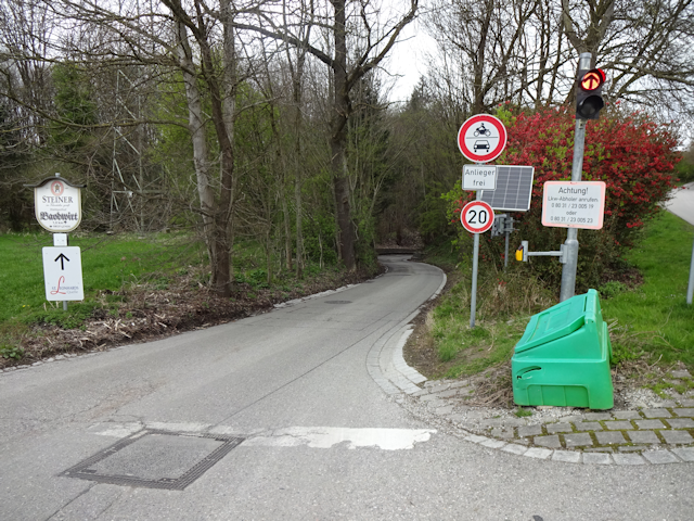
True enough, the road turns out to be quite narrow and obscured, following a valley that may or may not be natural down almost all the way to the floor of the Inn valley. Fortunately, me riding a bike can zoom down the road relatively unconcerned since I would not only hear any trucks coming from around the next corner, but there's also enough road at the sides of the road that I would be able to pull over and get out of the way if necessary.

But I encounter no truck, and soon I unexpectedly find myself within the factory yard of the legendary St. Leonhard Spring, a manufacturer of mineral water that is said to have healing properties. Legend has it that even the ancient Romans already valued this natural spring, and that in the 18th century it became a famous pilgrimage site. How much of that is true and how much just clever marketing, I don't know. But it sure is interesting finding oneself in the middle of several hectoliters of mineral water all of a sudden.

From there, I quickly draw closer to the Inn, passing over a dam-way between a nameless side-channel and the river proper.

I am now almost back at the river, and yet, ironically, before I actually get there, I must yet brave the water hazard. Looks like the floodplains are yet a bit... well... flooded.

After that, I finally reach the Inn. From here, it is only around 2km east to my stay place as the Cydaro flies. Unfortunately, however, Jycily is quite unable of levitation, and since there's no bridge across the joint Inn and Mangfall until roughly 13km further to the north, I have little choice but to head south and cross the two separately in Rosenheim again.

Thus it happens that I follow the floodplains of the Inn south for roughly 2.5km - a detour that should not quite be without its own little curiosities.

For starters, I encounter a shepherd with a sheep herd of roughly a hundred heads and a sheepdog, herding his animals just like that on the floodplains with no fence whatsoever to contain them, a sight that I don't think I have ever beheld so far, not even in New Zealand. Granted, there was that one time when I encountered a sheep herd on the road, but even those were contained by fences on either side (see Book I ~ Chapter 19 ~ The Takaka Tales).

Venturing into the riverside woods a bit in search of a Geocache, I also come across traces of beavers, such as trees with their bark chewed-off, as well as some smaller trees that have been felled altogether. In fact, let me use this as an opportunity to clear up a common misconception: While beavers do eat parts of trees, they are not actually interested in the wood, which is of little nutritious value. Rather, what beavers are after when they gnaw on trees is the cambium, the "growth layer" that leis between the bark and the wood, which is full of nutrients. If they gnaw beyond that, then that's because they want the wood as building material for their dams.

Also, while I certainly don't mind the ongoing Clearance right now, I have to say that it is somewhat upsetting me how the clouds are breaking up now and opening up a view to the mountains, now that I am back down in the valley again.

Eventually, I cross back over the Inn again by means of a moderately-sized car bridge...

...which is also where I come across this adorable little sticker that I can only wholeheartedly agree with ("Let their little hearts keep beating on, no one needs fur collars, no one!").

Then, on the other shore and with it back in Rosenheim again, I follow the Inn back north, and along the way come across a curious sculpture: A series of metal silhouette sculptures depicting a traditional ship-train with horses pulling the ships up the river, and with original proportions too! These ship-trains were an important part of trade along the river all the way into the 19th century, when it was replaced by the railroad.

A little bit further on, I reach the tip of the wedge of land separating the Mangfall from the Inn. Here, the two become one, and no bridges across the newly joined river exist for almost 16km downriver from here.

Well, no complete bridges at any rate. This one looks like someone decided to build a footbridge across the river, got started, but then realized "Whoa, wait, no! That's gonna be expensive!", and then just let it be.

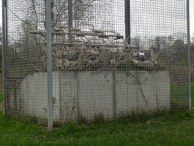
More interesting things abound on this little wedge of land - which is also known as the Innspitz ("Inn Point") - such as this quartet of caged and overgrown lawnmowers...
...or the mysterious talking path, which has a message worked into its pavement if you look carefully, and follow the path for a while.

Anyway, across the Mangfall I go here, and then I follow the Inn further to the north...

...until I eventually reach the "Your Bridge Here"-place, where I was standing on the far shore of the Inn over an hour ago, really wishing there was a way across there.

Moving on, away from the Inn I go, and now the road is straight and quick, leading me almost directly back to my stay place.

Yet along the way, I still come across the odd tiny rock bench...

...as well as a clever little sign advertising: "Freebie weeds for self-pickers!"

And then, after a harrowing and somehow unfulfilling ride - which nonetheless featured a number of little curiosities - I am back at my stay place. That evening, I warm up the leftovers of yesterday's Naleiayafero...

...before going to bed. There's another big day waiting for me tomorrow, but before we get to that, let us take care of...
The Retrospective
I had my own single room here, this time with a properly working door too, and the bathroom, though shared, had a proper shower to make up for it. Food, as usual, was not included, apart from a few basic cooking supplies, but the atmosphere was very familiar and welcoming (though it did get a bit loud at night). The bed, though comfy, was a little bit sweaty, which is something that happens to me with certain fabrics. Location-wise, this place was sublime, with shopping nearby, and although public transport options are not so good here, the view and generally nice area more than made up for it. Finally, the free WiFi worked, I had a kitchen to cook my food, the temperature was comfortable, and the cute cat kept me company. Also, the price-value ratio was one of the best I've yet encountered in Germany, making this definitely one of the better places I've stayed in on my travels.

Now, with that taken care of, let us embark on the last - and worst - part of this dreary Dragon Petal, which I will forever remember as the...
Mangy Mangfall Malaise
19-April-2023I'd say that this day has a problem... but that would be an understatement. More accurately, this whole day is a problem. If you looked at the weather forecast for today and asked yourself "Is this a good day for a bike tour", then the indubitable and blatantly obvious answer to that would be:

The basic problem with today is that the day starts with Drizzle, and ends with Storm. And here I am, having maneuvered myself into a bike ride in the middle of this wretched weather by courtesy of Ashley. I know I could theoretically always cancel the Petal and take the train back home, but... I don't wanna. I'd rather see things through to the end, even if they get uncomfortable along the way, because that's just who I am. I don't give up unless I'm entirely out of options, and so my plan for today is to get up as early as possible to try and get back home before the onset of the Storm... or at the very least as early as possible in order to avoid as much of the Storm as possible. Thus, I get up at 5:00 in the morning, and at this time of the year that means it's still pitch dark outside.

Breakfast takes the shape of a Chocolate Croissant and a regular Pretzel, along with some Sencha (high-grade Japanese green tea)...

...and despite the early hour, the cat - infiltrating the house via the balcony - comes to keep me company as I get ready for departure with the light slowly waxing outside.

Stealing away like a burglar in the... well... morning, I leave another empty room behind...
...and my departure is only observed by the cat, who keeps me company all the way to the door and beyond.

Thus begins the last part of this perditious Petal, which in its composition should play out a lot like a proper year in Against the Storm, starting with Drizzle.

Distance: 85.0km
Ascents: 360m
Duration: 9.25h
6/8 (+2 passed +2 skipped)🎁︎
The basic theme of today's ride is quite simple: Follow the Mangfall until the Knie ("Knee"), where it suddenly turns south at an acute angle, then make as much of a beeline as the terrain allows for the Großhesseloher Brücke, and from there more or less straight back home.
This simplistic plan also makes for a very straightforward height profile, as well as one of my shallowest crossings of THE BORDER. Basically, following the Mangfall upstream from Rosenheim makes for a steady, yet very shallow climb all the way to Feldkirchen ("Field Churches"), after which I have to climb across the Knie. But that's already the only major climb of this entire ride, and it isn't even that bad. With 130m of altitude over 4km, it is comparable in incline with yesterday's first AAAAAAAAAA, but both shorter and lower, if only by a little bit. And after that, it's downhill almost all the way, with only a few minor climbs near Kreuzstraße ("Cross Road"), and one last major bump shortly after Oberhaching ("Upper Snatching"). Even the Isar valley between Grünwald and München only makes a small dent in it on account of the Großhesseloher Brücke being a railway bridge, and thus by necessity having to cross the valley at a high elevation and with minimal gradients, lest the trains get stuck in the middle.

Whereas yesterday led me straight through the core of Rosenheim, today I'm travelling tangentially to the town's territory, thus the track traverses trails that take me through fields, and the paths there are more than just a little bit wet. Fortunately, this path is pretty solid, so despite the Drizzle I make good progress.

My way briefly takes me into the more urban areas of the eastern outskirts of Rosenheim...

...but before long, I reach the Mangfall - which at this point is split into the main river and a channel - at which point I turn east and leave Rosenheim behind.

For the next 2.5km or so, I should proceed along this trail, running between the Mangfall and its channel, which at the narrowest part are less than 15m apart, the Mangfall being to my left, and the channel to my right.

Eventually, this elongated strip of inter-fluvial land widens enough to hold a cemetery, houses, companies, and a curious sculpture labeled as the "Brücke der Freundschaft" ("Bridge of Friendship").

Meanwhile, I cross over to the south bank of the Mangfall by means of a more functional bridge, and in doing so get to see an interesting segmented cascade. I wonder if that's natural in origin, or arose as part of some renaturalization project.

From there, I keep on cycling along the dam-way on the southern shore of the Mangfall for quite some time. Under grey skies, along a grey river, and with the Drizzle sometimes intensifying, and sometimes fading. It could have been a nice ride in fair weather, but as things are, the best news are that I'm making good progress, thus improving my odds of getting back home before the Storm.

After roughly 8km up the Mangfall, I pass by the city of Bad Aibling ("Bath Yew-let"), which is located on the northern shore of the Mangfall. It doesn't have any particular relevance for this Chapter, but you may want to keep it in mind for a future chapter, where it might be of some relevance.

One thing of note is that this area is littered with a mega-freacking-HUGE amount of Frog-Geocaches, that is, Geocaches that you can only fish from their hiding places in trees with a 10-feet-pole. These are always quite annoying to me, because they appear as normal caches on the Geocaching map when I download them so I don't know that I have no chance of actually getting them until I stand right in front of them. And while normally this is still kinda okay, this particular area has been hit hard by an enthusiast who placed several dozen such caches along the Mangfall, meaning that only about 1 in 10 of all caches around here is not a Frog-Cache. Normally it's quite the other way around, with only 1 in 10 or 20 caches being of the kind that - while visible - is physically out of my reach.

Eventually, the path gets routed off the dam-way for some time without any better reason other than make the alternative path the winner of today's field path of the day. Objectively, this one is not so bad, but still, Drizzle, mud and wet grass make for a bad combination for cycling.

And to make bad things worse, the Drizzle gets stronger yet again, and my pants end up getting thoroughly drenched as a result. And once again, the water-resistant spots that resulted from my failed bicycle-repair attempts during the Broken Horse Petal become clearly visible (see Woe at the Walchensee).

After some time, there's a chance to get back up the dam-way again, and while that does not diminish the Drizzle, at least it makes the going a bit easier.

Roughly 16km up the river, I cross back over to the north bank of the Mangfall by means of a small pedestrians' bridge, and that should be the last time I cross the Mangfall... at least on this ride.

There, I encounter the railway line from Rosenheim to Holzkirchen, and my route leads alongside it for a bit.

And by the way,that's not a big signpost...

...that's a bike signpost!

After that, I keep on following the north bank of the Mangfall for a bit, and thankfully the Drizzle shifts into Clearance by now. Not a very sunny Clearance, mind you, but at least the rain stops for a bit.

I keep following the Mangfall until the village of Feldolling ("Field Olden")...

...where I finally leave it behind, right around km 24.354 from it's mouth.

From there, I proceed across an open field...

...right towards the town of Feldkirchen, where I've yet to encounter any churches.

And now, I'm in for the dread ascent of today. The climb up the incline in Feldkirchen is legendary, and my father still remembers stories from his childhood when he just barely made it up this very slope with his car in the snow and in the back mirror watched as a mobile home behind him lost traction and went crosswise over the road.

Fortunately, today we don't have snow - though it still is cold - and there's a cycling/footpath that I can use instead of the road. Even so, this is still a very steep climb with peaks of over 10% gradient, so while I am able to cycle up all the way eventually without pushing, I still have to make quite a few breaks in between to catch my breath.

Eventually, however, I do reach the top, and that brings some relief as the landscape levels up a bit there.

It is also up here that I cross over the route of my very first Petal Ride to the Thalhäusl (see Book III ~ Chapter 8 ~ Project Petal Part 1 ~ To The Thalhäusl) near the village of Oberreit.

Back then, I came down from nearby Blindham ("Blind Have"), and continued down the slope on a road that had an even more brutal incline, such as this one.

And whereas that time I was mostly going along the main roads, this time around I am taking the back roads through little villages such as Altenburg ("Old Castle")-

There, I come across what I imagine must be the remains of said old castle. Looks like they are presently in the process of massively upgrading them to Haus 365 ("House 365"). I wonder if that's supposed to be Bill Gates' new summer residence?

There's quite a few small villages crammed together on this little ledge of land, with the next one being Aschbach ("Ash Stream"), which interestingly begins shortly before Altenburg ends.

Yet after that, there are no more villages for a time, on account of more mountainous terrain, which I naturally have to climb.
Now this terrain is the very reason why the Mangfall, coming squat from the south and heading straight north up until this point, seemingly destined to merge with the Isar goes "Hahah! LoL! No! There's no way I'm going over that! Fuck that ridge, I'm turning southeast and flowing into the Inn" at this point. I'm sure the geological process by which this peculiar run formed must be quite fascinating.

But anyway, this climb, though kinda steep again, is still nothing compared to the one right after Feldkirchen, an so, I eventually reach the topmost point of today's ride at 680m and with reasonable effort. Now, I don't know if this peak has an official name, but I'm just gonna call it the Kniekappe ("Knee Cap").

It is also up here that I cross over into the Landkreis Miesbach ("Crappy Stream County").

Now, for those of you that plan to cycle up the Kniekappe, I can only suggest going up the east side - like I did - because the other side had a 10% incline again, which is considerably more fun to race than than to tread up.

And race down I do, getting enough momentum to race right through the first village in the lowlands on the other side, which is fittingly called Grub ("Pit"), and even more fittingly belongs to the municipality of Valley ("Tal").

After that, I cycle through a stretch of flat land, which I'm not sure whether to call uplands or lowlands. On one hand, they are a goof 75m above the valley of the Mangfall, yet on the other hand, they are still surrounded by hills on all the sides that are not the valley of the Mangfall. Oh well.

Anyway, it is here that I come across another "mythic" place of sorts, and that is Kreuzstraße. Literally everyone in Munich will know the name of this place, since it is the terminus of one of the S-Bahn lines, and as a child, when the S-Bahn lines were still routed differently, the S1 from Moosach which I frequently used was headed for Kreuzstraße, so I boarded the train for Kreuzstraße hundreds of times, but never once rode it to the end. And now that I finally get to see this place, it is not by train but rather by bike that I get here. I have to say that for an S-Bahn terminus, this is rather anticlimactic. Unlike literally all the other S-Bahn termini, which are all towns of varying sizes, Kreuzstraße is a tiny village of only a little more than 100 inhabitants and not even 40 houses. It consists mainly out of the two roads forming the eponymous crossroads, and little more. By contrast, the second-smallest terminus town, Mammendorf, has almost 5,000 inhabitants.

Well, I suppose the railway lines need to end somewhere, and apparently it was too much effort to extend the railroad down into the Mangfall valley into the significantly larger Feldkirchen. That much I can understand. However, what I can't understand is why in the name of Dragon they did not simply extend the S-Bahn line one single stop further along the already existing railroad track, because then it would have terminated in the significantly larger town of Holzkirchen, which incidentally is already the terminus of another S-Bahn line, so people would also have been able to profit from a more interconnected network (kinda like how the Munich airport is also reachable by two lines).

But enough of that. Cycling north from that crossroads, I realize that I must have grazed the county of Miesbach near its northernmost end, because after no time at all I already find myself within the county of Munich.

Shortly after that, I deviate from the paved paths, and head into the nearby Hofoldinger Forst ("Farmyard Ravine Forest"), which covers an area of at least 40km² (or more, depending on how much of its appendixes you include). And within that forest, my first destination is the Grotte ("Grotto"). Interestingly, this is also where I meet the first person in a long time who is truly outside today, and some distance from the nearest house or other shelter.

I manage to find the Grotte without much trouble, despite the fact that it turns out to look exactly how I didn't expect it to look. Turns out this is actually a little chapel, in which stands enshrined a statue of Mary, carved into the hollow of an oak tree. A nearby plaque informs me that this used to be an open-air installation, until in the early 20th century the oak - which used to be a flourishing tree - got zapped by lightning, and the top had to be cut off. After that, the roof structure was erected around the site, and ever since that it has been called the Mariengrotte ("Mary Grotto").

What follows next is a looooooooooong mostly ride through the forest, mostly along a straight road. In fact, this is kinda similar to my ride to Rosenheim in the Ebersberger Forst, though back then I was a bit more relaxed, and this time I am hastening as fast as sustainably possible in order to get back home before the Storm. In fact, it turns out that both of those "straight forest segments" were pretty much exactly 5km long. What a coincidence!

Soon I come across the old Römerstraße ("Roman Road"), which follows the run of the ancient Roman Via Julia running from Augsburg all the way to Salzburg. It runs south of Munich, and I'm sure I already crossed path of its run here and there on previous Petals, though at this point it's hard to piece together when and where. Maybe I'll endeavor to follow it's run, one of these days. For now, I follow it only for a few kilometres, as it happens tu run just the way I need to be going right now

A little ways down the Römerstraße, I finally come across a paved road again...

...which I completely ignore and proceed a little bit further along the Römerstraße...

...at least until I arrive at an obstacle which I am almost certain was not here in the times of the ancient Romans. But who knows, maybe in a few thousand years, remnants of those highways will be all that's left of our civilization.

By now, it is already past noon, and I am starting to get hungry. Yet with that threatening sky hanging above me I really do not want to just sit down anywhere out in the open (and all such places would be drenched anyways). So, instead of navigating back to the Römerstraße on the other side of the highway, I instead follow the highway access road to the nearby town of Sauerlach ("Angry Laugh"), hoping to find some sort of shelter there.

True enough, as I approach the S-Bahn station here, I come past a playground that features a little roofed shelter.

And although every surface of the shelter is covered in crude graffiti of one sort or another, at the very least it's dry, and so I can sit down and eat my lunch here with relative peace of mind. Lunch, that is a Mohnschnecke ("Poppy Snail") and a piece of baked goods that is effectively two layers of cookie with jam in between and one half chocolate-glazed, which goes by the poetic name of Flammende Liebe ("Burning Love").

After that break, I follow the northward road towards Taufkirchen ("Baptism Churches") for a while...

...and then turn off into the forest for yet another time.

Emerging from the forest, I realize that what little luck I had on this ride may be about to expire, as I notice the darker clouds in the north, which is regrettably the direction that I'm going. One little solace is that these clouds seem to be more towards the east, and I need to go more towards the west. However, even so, at this point I already mentally prepare myself for the onset of the Storm.

But before that, cycling through the outskirts of Oberhaching, I still get the honor of cycling upon a freshly-laid sidewalk. And with freshly-laid I mean that I literally pass by the construction workers working on the next section.

The first drops of rain begin to fall as I follow a field path running right outside the Autobahnring ("Highway Circle")...

...and by the time I cycle through a little fir tree grove in the Grünwalder Forst ("Green Wood Forest"), the Clearance has officially come to an end.

Bright though it may be, it is still quite rainy, which makes the ground quite muddy, and also renders me unable to navigate by my phone-map, because the raindrops falling on the display register as touches and mess everything up. Now, normally that would not be a big problem, but the issue here is that the paths in this part of the forest are quite twisty-turny, and not at all straightforward, so I end up going a bit zig-zag here, along paths some of which are not even on the map.

However, eventually I do manage to reach the railway line which is going across the same bridge that I, too, am intending to cross. So that's about as good a track to follow as it gets, even if the path near it is not particularly bike-friendly in this wet weather.

Meanwhile, a very welcome sight indeed is this nearby underpass beneath the railway line nearby. Stopping in the dry spot beneath, I take this opportunity to take out my trusty tri-Comm and plot a course to the Großhesseloher bridge with the following three requirements in mind:
- It should lead over roads that are reasonably solid
- It should be as short as possible
- It should be easy to memorize, so I won't have to navigate again until I reach the bridge, which is the next guaranteed dry spot that I know of

Of those "reasonably solid" ends up being the dump-requirement as I end up focusing on easy-to-remember route that leads me across the grid-like forest roads, which I assume are at least basically okay. Here's roughly how I memorized it:
- After the underpass, do a right-left-right combo
- Follow the forest road until just before it becomes just a minor forest path, then turn right
- Just before that road would lead you beneath the railroad tracks again, turn left
- Follow that path until you fall into the Isartal ("Isar Valley"), then turn right
Interestingly, the first forest road that I take also runs along the Munich reservoir overflow channel, which as a matter of fact seems to be quite full.

Moving on from there, I come by some sort of construction work where major insulated pipes are being laid parallel to the forest road. I wonder what they are being used for. Teleheating?

After just a little bit longer, I reach the Isartal, which at this point does not look very impressive on account if it being covered in trees.

Now I have just one last obstacle to clear...

...and then I am safely within my next dry spot: The Großhesseloher Brücke, where there's a joint bike- and footpath beneath the railroad tracks above, and a solid roof separating the two. You could say it's a bridge and an underpass simultaneously.
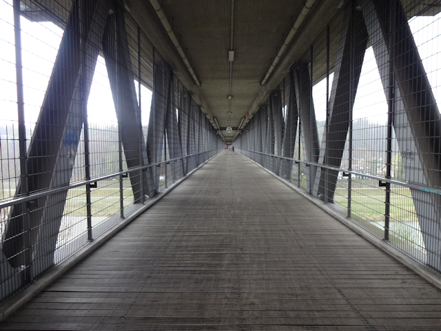
Though, as I have to find out, "dry" is a relative term here, since the whipping winds from the north blow rain halfway across the bridge.

But rain or no, at the very least the vantage point from atop the bridge offers a great view up and down the Isar valley.

It does, however, also leave me dreadfully exposed to the notably cold winds, and so I end up taking shelter near the far end of the bridge where it ends in a small concrete structure that offers at least basic protection.

I had planned to look for two more Geocaches along the ride, but with the Storm having come, those are now officially cancelled, and my prime goal is to now get home with as little navigating and detours as possible. For starters, that includes cycling through the roads of the suburban areas of Munich, which I have now officially entered...

...as well as taking advantage of any underpasses along the way to dry and warm up a little bit while navigating the next segment of the ride.

Even so, I inadvertently end up taking wrong turns and little detours every now and then...

...which I only notice when I find the next little roof to stand under and check my map.

Eventually, however, I manage to find my way to a major thoroughfare, which I figure I can more or less follow all the way back to Laim, and from there I'll be able to find my way back home without problems. (Naturally, with all of this being part of my territory, I would have been able to find my way back home without navigating eventually, but with the Storm drenching me I really wanted to get back home by the fastest route possible).

That abandonment of all further navigation brings with it an advantage: I can finally equip my winter gloves, because it is in fact so cold by now that my hands are getting stiff. That is the first time I've had to equip those gloves on a Petal Ride!

Also, my pants are so thoroughly drenched that by now even the aforementioned water-repelling stains on it are starting to get hard to see. So much for waterproof.

As for a straightforward path back home... it turns out that this applies only to cars, while pedestrians and bicyclers such as myself are forced to take a ridiculously convoluted path to get across the A95 highway.

But anyway, after that, I am finally on the victory road, which in this case is the Fürstenrieder Straße ("Lord's Reed Street"), and another 5km-straight-segment, but through urban canyons instead of forests this time around (though there are some trees around).

After that last long straight stretch, I arrive at the Laimer underpass, which at this time is still closed to cars for construction, though fortunately not for pedestrians and bicyclers. I guess this time it's the cars' turn to take the scenic route around.

On the last stretch back home, the Storm intensifies yet again as I cycle around the back of the Nymphenburger Schlosspark...

...and then, finally, I arrive back home at the Fox Loft.

Thoroughly drenched, of course, but since this section has already gotten kinda long, I'll tell you more about that when we get to...
The Road Ahead
So, here I am, back at the Fox Loft, and drenched to the bone. Even my camera is drenched!

In fact, the first thing I do upon returning home is hang up my shoes to dry.

And my pants feature a new and exciting pattern of wet and dry spots that seem to be of some interest to Jamie, one of my two cats.

Finally, my three tails are also quite wet and need to be hung up for some drying.

And thus ends this wretched, premature Petal Ride, which I advanced one month for the sake of Ashley, who should not show up the following day, leaving a fox heartbroken. But life goes on, somehow, and there's still two more petals to complete, as well as one petal to fix. And yet, they should have to wait, because a number of other exciting (and considerably less rainy) adventures should await me. So if you want to know more about them, be sure to stay tuned for the next chapter of the Travelling Fox Blog!