- Part 9 ~ The Petal of the Wolf
- Ample Ascents Around Allach and Altomünster
- The Place
- Goods from the Gallery
- Approaching Adelsried
- The Retrospective
- Gaming the Gap
- The Road Ahead
This should be my final ride for 2022. Starting just a few days after
Elgen broke up with me, I welcome the opportunity to physically exhaust
myself and hopefully clear my mind a little. Since my last two directions
were straight north and south, and I already did the straight east and
west petals, this time around I head towards west-north-west, thus
choosing...
Part 9 ~ The Petal of the Wolf
24-October-2022 - 26-October-2022
My target destination for this ride is the nearby city of Augsburg, which holds some significance for me. Living in the northwest of Munich, Augsburg is the next city, and during my life I have met a few people who lived in Augsburg and worked in Munich, taking the train each day, which takes about an hour. The son of my father's girlfriend used to live there too with his wife, and as a matter of fact, I tried to visit them a few times, but it never worked out, and by now they have moved somewhere else. So now I've simply booked an Airbnb and set out towards Augsburg, exploring the terrain between here and there as I go. As it turns out, there are...
Ample Ascents Around Allach and Altomünster
24-October-2022Distance: 72.0km
Ascents: 450m
Duration: 7.75h
5/9🎁︎
As I set out, my route takes my north-north-west at first, which is clearly an inauspicious direction. Not only are there a lot of hills and ups and downs that way, but I should also end up getting quite wet once again, as I did the last time I embarked in that direction (see A Song of Rain and Sunburn). Now, the interesting thing about Augsburg is, there's already a natural petal shape in that direction, formed by the A8 highway and the train route. Roughly following those contours, my theme for my ride to Augsburg is to stay north of the A8 the entire time. As such, my route first takes me north to Dachau, after which things start getting hilly. The next destination is Markt Indersdorf ("Market Indian's Village"), where the river Glonn ("Shine") cuts a valley through the hills... unfortunately not in the direction I'm heading. There, I turn west, pass by Altomünster, eventually cross the valley of the legendary Paar, and a few more hills later make my way into the Lech valley in which Augsburg is located.

Admittedly, the weather does not look all that flash when I set out, but since I've already booked the Airbnb and all I figure I might as well give it a shot and maybe I'll get lucky.

Now, one good thing about going in that direction is that I'm out of the city in a matter of 20 minutes tops, and then I get to cycle across the lovely landscape.

One relaxing ride later, and I am already at Dachau, where the palace of Dachau stands imposingly atop the hills that mark the end of the Munich gravel plain in that direction.

However, you will notice that I mentioned hills, and that means that the ride is gonna get a lot tougher from here on out. In fact, the very first ascent right here and now is the steepest one of the entire ride. On a plus note, however, I need to get off and push anyway since this is a one-way road.

And speaking of ascents and inclines, here's the height profile for today's ride. The ride to Dachau is actually mildly downhill, and then things start getting a bit bumpy. The worst parts are actually right before Altomünster, and then thereafter, where I reach my peak altitude of 540m at the Pfaffenberg ("Priest Mountain") near Pfaffenhofen ("Preist Farmyard"). After that, there's more ups and downs, and I eventually reach the lowest point as I cross the Paar at 460m. So I manage to rack up quite a few meters of altitude despite the maximum amplitude being only 80m. Finally, I go down into the Lech valley by means of a steep downhill segment that I really, really, really, really, really hope I won't have to cycle up again at some point on my return trip, and after that it's a smooth and gradual incline for the remainder of the way until Augsburg.

Having passed through Dachau, I next make my way into the hills through rural roads and forests. The signs of autumn are all around me, and while many trees still sport fresh green verdure, others have already shed their foliage and red and orange leaves litter the wet roads.

Eventually, I get out into the open and pass south of the two windmills north of Dachau...

...and then make my way through the relatively flat uplands of Dachau by means of idyllic cycling highways near not-at-all-busy roads. The weather is still dry too, although the sky is threatening, and I wonder how long it will hold. All in all, this is the most enjoyable part of today's ride though, and I manage to leave at least some of my worries behind for the time being.

Up there, I pass through little hamlets such as Unterhandenzhofen ("Underhanded Farmyard") where horses graze the pastures...

...and eventually pass through Niderroth ("Lower Red"), where I briefly cross over to the west of the legendary A-line for Altomünster (now part of the S2). That line takes a bit of a roundabout run through the hills here. Incidentally, the town sign looks like some drunk driver accidentally missed the road by a bit.

The next place I pass through is Ried ("Reed")...

...where I happen upon a four-exit traffic circus built with commendable determination, complete with cycling and foot paths being routed all around and across little traffic isles in the middle... and it is full of determination that one of the four exits purposefully heads east towards a field, and then abruptly stops.

Moving on, I next reach Markt Indersdorf, where I not only cross back over to the east of the A-line...

...but also cross the Glonn, which is either a little river or a small stream, roughly the same size as the Würm.

It is also there that I come across a cleverly disguised geocache. Hidden in plain sight, no one who isn't looking for it would notice it because nothing looks out of place.

Also, I notice that I'm officially in the rural parts of Bavaria now since I pass by a Bixnmacherei ("Can Makery"), which is a playful sign put up by new parents to announce the birth of a female child. Founded on the Bavarian dialect - where "Bixn" was also used to refer to a girl - this once wide-spread custom can now only be found in the rural pats of the country.

After Markt Indersdorf, I turn off the paved roads for the first time today and follow various field paths west. By now, I have actually already cleared all of my required distance towards the north, and Augsburg is actually located precisely to the west of here. However, since my theme for today is staying north of the highway until I reach the Lech plain, I should later on still head a little bit further to the north.

I briefly get to ride on a paved road again as I pass through the village of Albersbach ("Silly Stream")...

...but that is only a short reprieve, and afterwards I have to make my way across the Field Path of the Day. Fortunately, this one is a rather tame winner of this award.

On the plus side, that path is only relatively short, and I get to ride on a dirt road again soon, but on the minus side, the weather is starting to look more and more gloomy. At this point, I'm afraid it's only a matter of time before the heavens open up.

Sure enough, by the time I reach Riedhof ("Reed Yard"), a light drizzle has begun to fall, and regrettably, it's gradually getting stronger.

By the time I reach Schluttenberg ("Chasm Mountain"), the drizzle has matured into stage 2 rain...

...and as I cross over into the county of Altomünster, it has become proper stage 3 rain. That's normal rainfall, and I know that my trusty coat Krevyasz can handle it for about 15 minutes without soaking through... which unfortunately means that since I still am several hours away from my destination and the rain doesn't look like it's gonna let up in the near future, there's an approximate 100% chance that I'll get a breach and end up soaking wet.

The next place I pass through on this now rainy ride is Deutenhofen ("Pointing Farm Yard"), which is not only remarkable for the bright read bushes near the road...

...but also by this house, where clearly a very determined architect did not let himself be stopped by the fact that his house was too big to fit the lot, or that there was a road in the way, so he found a very clever solution for that conundrum. Here's hoping no tall trucks ever try driving by there.

Also, if you thought that last traffic circus with the dead exit was already interesting, here's something even better. This streamlined traffic circus has absolutely no unnecessary exits whatsoever!

The final village I pass before Altomünster is Stumpfenbach ("Dull Stream")...

...where I pass by the male equivalent of aforementioned Bixnmacherei: A Lumpnmacherei ("Rag Makery"), from "Lump" which is a Bavarian term for "Boy". Welcome Tobias, whose birthday is three days before and 35 years after my own. That means that little guy is now 23 days old!

Just a little bit further, and I arrive at Altomünster, where I ride past the northern terminus of the railway line. Funnily, I've never gone here by train, but it's now already the second time that I've been here by bike.

Moving on, I fight my way through the rain across the highest ridges of this ride. On the plus side, there aren't many cars around, but a few of them do brave the rain.

And while the climb is definitely noticeable, it is at least manageable and steady at roughly 2%, so although I reach the highest point of my ride at Pfaffenhofen, it doesn't really look like it because there are no steep hills around.

But my legs do notice the difference, and so here I am, tired, drenched and heartbroken. At least the first two more immediate concerns do somewhat distract me from the third, and as I reach the village of Wollomoos ("Wooly Moss"), I even find a bus stop shelter that I can use for my lunch break, and to dry off just a little. There's no bench inside, but with all the rain soaking my clothes, I don't really feel like siting down anyway. Lunch comes in the usual form of a sandwich, Müsli bar and some water.

Initially, I hope that the rain will pass, or at the very least let off a little while I eat lunch, but I have no such luck, and since I have no way of knowing how long the rain will last and still have quite a distance to cover, I can't wait for too long, and so I eventually set out into the rain yet again. It's somewhat annoying, because being in the uplands like this, I would have gotten a good view if the weather was any better. But even as it is, I still get a good view of the 2*3 windmills south of Aichach. And I just noticed, all the windmills that I passed on this ride, I left on my right. Incidentally, this is also where I enter the county of Aichach-Friedberg ("Oak Stream-Peace Mountain").

Next up is Sielenbach ("Silo Stream"), and since I just told you that I passed the highest point of my ride, it should come as little surprise that the ride here took me downhill. Normally, that would be pleasant and enjoyable, but with the cold rain and all, it merely serves to cool me down more. Cycling uphill is actually way more enjoyable in the rain than riding downhill.

In Sielenbach, I pass another rural tradition that I've written about before, namely the age poles that depict things that are important to that person. As a matter of fact, here's a stretch with several of them at once!

Not wanting to follow the main road, I leave Sielenbach towards the south, which inevitably takes me past a number of interesting places. First of which is the impressive pilgrimage church Maria Birnbaum ("Mary Pea Tree"). It's origin was a pieta that was created in the 16th century and got pillaged and partially destroyed during the 30 year war. A shepherd eventually found the ravaged pieta and put it up in a hollow pea tree, which soon became the site of several miraculous recoveries which brought fame to that place. The rest is history, and today a majestic church decorates this holy site.

Aforementioned shepherd probably came from Schafhausen ("Sheep Housing"), which is the village that I pass through next...

...and also appears to be the headquarters of the Brauerei Kühbach ("Brewery Cow Stream"), or at the very least the home of someone who likes that beer a lot (and just turned 60).

Following Schafhausen, I proceed on some quiet, idyllic, though regrettably muddy backroads. Also, I pass close by the southernmost of the six windmills that I saw from the ridge earlier.

Next up is Rieden ("Reeding"), which offers only limited winter service for whatever reason. Fortunately, it does offer some adequate rain service instead, in the form that it has a few shelters that I can stop by and warm up for a bit before continuing. I may not get much drier, but it's crazy how quickly riding generally downhill while wet can cool you out.

The next village is Laimering ("Gluer Ring")...

...and it is there that the rain turns up the swag to stage 4, forcing me to seek a barely adequate emergency shelter in an underpass beneath the B300 state road. The sidewalk here is barely wide enough for me and my bike, and every now and then a truck passes by from the nearby gravel works. But I have little choice, because the rain has become quite harrowing, and my pants are thoroughly wet except for those few spots that were stained by the puncture repair spray and are waterproof as a result (see Book V ~ Chapter 13 ~ Project Petal Part 8 ~ Alpine Abortion).

I only wait out the worst of the rain there, and then I proceed past Neumühle ("New Mill"), where at this point not even horses are still left outside.

It is there that I pass over the Paar, that legendary stream that almost flows into the Lech, approaching it to a distance of roughly 2km and coyly flowing through the Lech valley for over a dozen kilometres, and then spontaneously decides: "Nope! Not gonna do it!", turns northeast, cuts its way through several hill ranges and eventually flows directly into the Donau. On all my rides, I have now crossed it six times in total, and passed south of its spring on one occasion.

I could have just followed the run of the Paar upstream here and followed it to the Lech valley with little effort or ascents, but doing so would have taken me south past the A8, and since we already covered that staying north of that one until the Lech valley is my theme for today, I continue west across the next chain of hills, passing through the village of Taiting ("Place of the People's Ruler"), which is the end of all bicycling roads.

Subsequently, I make my way up past Bitzenhofen ("Rushes Farm Yard") and Sophienhof ("Sophie's Farm")...

...until I eventually reach the final apex of my ride, from where I can spy the very distinctive monolithic church tower of Derching ("Oak Place").

And it is from there, that I finally get a look on the city of Augsburg, which is actually already right below me. I would have gotten an even better view if the weather was any nicer, but at the very least the rain slowly seems to let up by now.

The next part of the ride passes in a rush as I zoom down into the Lech valley, cashing in 60m of altitude in the space of less than a kilometre, and before I know it, I am down in the valley, across the highway, out of the rain, and on the outskirts of Augsburg, where an old steam locomotive decorates and industrial compound.

With that, I am now on the final stretch of today's ride. Making my way deeper into Augsburg, I notice that the city appears to be preparing for a festival of sorts: Colorful trucks and containers are standing around on a number of squares, and wooden stalls are being constructed all over. I wonder what this is about.

Being in a city again means that the roads quickly get busy with cars again, and before long buses and even trams join the fray as well. Pedestrians are also about, and even a few bicyclers such as myself - though I doubt any of them have come as far as I did today.

By now, I am more or less making a beeline for my stay place, but before I get there I still cross over the great river Lech, flowing majestically under one of Augsburg's five bridges.

The final notable structure that I pass by on today's ride is the Jakobertor ("Jacobin Gate"), one of Augsburg's five remaining city gates from the 14th century, and bane of large trucks wanting to enter the city up to this date.

And then, I finally arrive at my stay place, a humble flat in an old block.

Naturally, it turns out that the flat is on the fourth floor, so I yet have a bit of a climb ahead of me, but then I finally arrive at...
The Place
The place I'm staying at is a little apartment where a woman with Japanese root by the name of Yukiko lives. Imagine her surprise when I greet her in her native tongue! It is also a very stylish place with colorful decorations on the wall such as this crane.

There, I get to stay in the room that clearly once belonged to her son. It's not big, but it has everything I need and more.

I have little need for the TV, but the laptop-friendly workspace is very welcome, and I should put it to good use.

The room's door, meanwhile, does have a little issue: Namely that it doesn't close properly and opens up on its own on account of this being a kinda old house. So I have to put a little stool in front of the door whenever I want it to remain closed.

The bath is okay-ish, with the one major flaw that it does not feature shower-curtains, which makes showering a bit awkward.

The kitchen is also okay. Nothing fancy, but it will suit my needs, and the old cooking plates do remind me of my childhood.

As for my trusty bike Jycily, he gets to stay in the basement, where there's a dedicated room for all the bikes. Carrying it through the door and downstairs is even more awkward than back home, but I do manage.

For today, I don't have much more planned, only there's still one thing I have to do unless I want to go hungry, and that is go and get some...
Goods from the Gallery
24-October-2022Yukiko tells me that the closest shopping options are located in the nearby City-Gallerie ("Stadt-Gallery"), a nearby city mall. It is indeed very close nearby, little more than 500m away, and in fact, I cycled past it on my way to get here and made a mental note of it.

Thus, actually getting there is fast. Before I go in, however, there's a bunch of notable things. For one, on the square in front of the City-Gallerie, there's another wooden construction going on, presumably also in preparation for the festival. This one is clearly larger than a stall, so I assume it's going to be something like a small beer tent.

Next is the river that runs beneath the square. It is mostly underground, but there's a few channel-like openings that let you look down on it, which makes for an interesting cityscape. This little stream is called the Sparrenlech ("Boarded Quick Stream"), which indicates that it was probably boarded up for a long time already and by now is used to running underground. In fact, some concrete "boards" still span it today. I wonder if that's an intentional design in reminiscence of how it used to look?

But now onwards to the City-Galerie, which dominates one entire side of the square!

It is a spacious and modern mall that covers an area of a little over 8 acres and features two stories of shops. It has a lofty hall with a fountain and a glass dome roof in its centre, and a parking deck on its roof.

Most importantly for me, however, it features a supermarket. This one is a Feneberg, which is one of the less common supermarket brands of Germany. With only roughly 300 branch offices (as opposed to, say, EDEKA with over 9,000!!!!!!!!!!), it doesn't even make it into the top 10 of German supermarkets, which is kind of a shame because I really like the atmosphere in there.

There, I shop for cooking supplies for the night, and baked goods for tomorrow, and returning back to my stay place, I soon go about preparing my well-deserved warm dinner for today. By now my clothes are almost dry too! Almost!

And that dinner is - you guessed it - Naleiayafero ("Dragon-Style Minced Meat"), my by-now-traditional dish on these cycling tours. Back when I learned it from Gemoron the Dragon in Würzburg, I never thought that the recipe would come in this handy, but it is easy to prepare, tasty and filling, and thus precisely the right thing after a taxing bike ride. Conveniently, the recipe always makes two portions, so I have enough for the next day too.

And that's it for today! I go to bed not long thereafter, happy to get some rest. After all, tomorrow I need to be fresh and ready for the next ride, where I should be...
Approaching Adelsried
25-October-2022
I begin the next day with a breakfast consisting of a chocolate croissant and some sort of other crescent-shaped pastry the name of which has slipped my mind. To go with it, there's some tasty Kabuse-Cha, which is a sort of green tea that has been grown in the shade (thanks to Yukiko for letting me try this).

After that, I soon set out. Today, the weather still looks a bit uncertain, but at least foreca said that it's gonna be a sunny day today (unless yesterday, and, regrettably, tomorrow too), so I am reasonably confident that today's ride is gonna be somewhat more enjoyable.

Ascents: 500m
Duration: 7.5h
6/12 (+1 passed)🎁︎
For this ride, I have endeavored to do something unprecedented for me: The last time when I was in the Lech valley, I only made it right until the edge of the valley, but did not actually cycle up the other side. This time around, I intend to actually cycle up the other side of the valley, and so my route today takes me straight west through Augsburg and to the edge of the valley, and then northwest through whatever hills are in my way until I reach the village of Adelsried ("Nobility's Reed"), where a conveniently located Geocache marks a good turning point. After that I head back east into the Lech valley and then all the way across till I cross over yesterday's route, thus extending the amount of A8 in my territory by roughly 17 more kilometres. From there, I should head south until Friedberg ("Peace Mountain"), and then back west into Augsburg.

A direct result of my lunatic decision to head into aforementioned hills is naturally that today should feature even more meters of altitude than yesterday. Crossing the little hump separating the Lech from the Wertach ("Value Stream") is easy, as opposed to crossing the Sandberg ("Sand Mountain") separating the latter from the Schmutter ("Muck"). After that, there's more fun inclines as I make my way up the Dachsberg ("Badger Mountain") and its many siblings, with Adelsried being located in a hollow again. Following that, I need to cross the Axtesberg ("Axe's Mountain") - which at 560m is also the highest point of today's ride - in order to get back into the Lech valley and subsequently the lowest point of the ride at 450m as I cross back over the Schmutter again. After that it's easy going until I reach the other side of the valley and go for a short climb up that side in order to pick up a Geocache that I skipped yesterday because of the rain, and the rest is easy going.

But one thing after the other. First, I make my way to the Rotes Tor ("Red Gate"), which is yet another of Augsburg's five remaining city gates and quite colorful. Incidentally, the nondescript building to the left houses the Augsburger Puppenkiste ("Eye Castle Puppet Box"), a famous local puppetry theatre.

Soon thereafter, I cross my first river today. This one is a broad river of steel almost a hundred meters wide, and trains pass by beneath as I watch.

On the other side, I make my way through the Wittelsbacher Park ("Ruler's Stream Park")...

...which is also where - looking back towards the east - I get to see the sun rise. Since it's already a month into the winter semester and we still suffer from daylight saving time, the sun actually rises quite late.

Only a short distance from there, I cross over the Wertach by means of the Gollwitzersteg ("Gold White Jetty"), which is a small pedestrians' and bicyclists' bridge. This is, in fact, the third time I crossed this river, since I also crossed it twice the last time I was in the Lechtal (see Interlude ~ Project Petal Part 4 ~ Lechtal Liveliness). It actually runs parallel to the Lech for over 35km with only little elevation in between, and whereas the Lech typically marks the eastern end of the valley, the Wertach runs near it's western edge. However, today, I should cross it only this one time, for you see, the confluence of the two rivers is right here in Augsburg, and the city originally occupied the strategically valuable position in the wedge between the two rivers.

On the other side, there's a very conveniently located bicycle road that I can follow, and as the sun rises further I can see that it is indeed gonna be a nice and sunny day. Good thing I put on sunscreen.

Passing through the Sheridan Park, I come by a kinda cubic church...

...and the next park over holds an interesting combination of an E-bike charging station and a fitness parcour. And there in the distance I can already see the edge of the valley that I am gonna brave.

But that is then. Now I get to enjoy a ride across blissfully sunny and flat meadows...

...and through beautiful autumn forests. However, that forest is also where the going gets really steep at times, as I am skirting around the sides of the Sandberg. Fortunately, the paths are made out of reasonable material, so although the climb is taxing, it is not impossible.

Eventually I make it over and across, and reach the town of Steppach-Vogelsang ("Veld Stream-Bird Song").

After that, I get some respite as I cross the flat valley of the Schmutter...

...which I cross not long thereafter. Incidentally, a nearby signboard informs me that this is actually a historic place, because it was here that the final battle of the 30 year war was fought, and ended in a stalemate where neither the Bavarian army nor the French-Swedish Army managed to cross over the Schmutter onto the opposing side. Shortly thereafter, the Peace of Westphalia was signed.

Schlipsheim ("Necktie Home") is the name of the village nested against the western edge of the valley here on the other side of the Schmutter...

...and after having climbed some distance up the hills on this side, I also get a nice view of the Schmutter valley looking back east. The Lech valley, meanwhile, is out of sight on the other side of the Sandberg visible against the horizon.

It is also right here in the middle of Schlipsheim that I have to fight my way up a deceptively steep road, desperately trying to reach the May pole in the distance.

However, I am rewarded with a stretch of relatively flat and exceedingly idyllic country, and I am thinking "This! This is what yesterday could have been like if the weather had been better!". Oh well, at the very least I am glad that the weather is better now and enjoying it to the fullest.

And yet before long that enjoyment ends as I reach the edge of the forest, and here's a truth that fits almost everywhere in the whole world: If you're in hilly country with farmland speckled with forests, then the forests almost always hide steep hills. As is the case here, where my adversary - the Dachsberg - lurks and hits me with inclines of almost 10% as soon as I enter the woods.

Up at the top, there's the memorial for the fabled Schwarzer Reiter ("Black Rider"). A Hussar in the 7-Year War (lots of wars going on around here at this time in the past), he got lost in this forest and ended up arresting the band of robbers of the Schwarzer Peter ("Black Peter"), thus earning him this name. After being lost for three days, the tolling of a nearby bell finally helped him find the way to nearby Horgau ("Listen Meadow").

After that initial climb, there's still a bit of up and down, but all in all, the way through the forest is relatively flat, if at times a bit muddy after yesterday's rains.

It is here that I come across yet another very cleverly disguised Geocache, hidden in plain sight, totally inconspicuous if you're not looking for it, and yet just slightly out of place so you are drawn to it once you are nearby and looking for something that stands out.

I hit a low point in the height profile as I cross a road cutting straight through the forest...

...but I do not follow it, instead opting to climb the hills on the other side. That route looks deceptively easy, but the incline is actually kinda steep.

I eventually cross over the A8 by means of a quite natural-looking ecoduct. If not from the noise of the highway below, you would not even know it's there at all.

On the other side, there's just a little bit of woodland remaining, and then I finally approach my turning point of Adelsried.

Regrettably, I do not find the Geocache that is supposedly hidden here. Instead, I turn east and cycle across the green meadows of the sizable clearing surrounding the village.

At the edge of the clearing, the next harrowing climb awaits me, and this one should be the longest and highest of this entire ride, taking me up a full 70m over a distance of less than 2km, ascending the Axtesberg to the climax of today's ride. On the plus side, after that the road takes me downhill for a long distance, and since today the weather is nice and warm, the downhill ride is quite enjoyable.

And it is here in the depth of this remote rural forest that the rare and elusive albino Mercedes can still be found, lurking by the wayside.

Riding downhill through the forest is already nice, but it gets busy as I emerge from there and onto a nicely paved and straight road through the valley following the Hahnenkamm ("Rooster Ridge"), and I can just let go of the brakes and let my momentum carry me as fast as air resistance allows for. There's not even a car in sight, and I got the road all to myself. What a rush!

There's a short bit where the road goes uphill again as I approach the village of Rettenbergen ("Saving Mountains")...

But that's okay since I wanted to stop somewhere around here anyway for lunch, and as it happens, Rettenbergen does offer a very convenient location for doing so: Located right next to a church with no windows or doors on its face, there's a roofed bench that would have been great even in the rain (though not in a storm), and the view is fantastic too! Lunch today consists of an Aprikosentasche ("Apricot Pouch") and a Doppelschnecke ("Double Snail").

Moving on after lunch, I pass a patch of curious vegetation, with a tree that seems half-alive and half-dead standing in the middle of a patch of red in a field of green. And speaking curiosities, there's also a partial eclipse happening right there and then, and I even brought my eclipse glasses, but what what with the nice weather and beautiful landscape, I have completely forgotten about that at this point, and since the occlusion is too light to be actually noticeable, I should only remember when I get back to my stay place and see it on my day plan. Oh well.

The road takes me further downhill until I reach the village of Batzenhofen ("Chunk Farm Yard")...

...which is where I reach the low point of today's ride as I cross back over the Schmutter again.

On the other side - now officially out of the hills and into the Lech plain again - there's a remarkably well maintained bike- and footpath...

...that takes me straight to the town of Hirblingen ("Warrior Villagers")...

...on the far side of which I cross the clear winner of the Field Path of the Day. Again, however, this is a relatively tame winner in this category.

I do, however, note a bit of a curiosity: Moving slowly on a path parallel to mine, there's a machine that looks somewhat like a small dump truck with it's dumper permanently angled upwards. However, with the plants from the field cutting off my line of sight to its lower half, I can only wonder about this mystery machine's meaning.

Less enigmatic though still a sight I don't see every day is the lone deer keeping a comfortable distance from me in the fields. As a matter of fact, a lone deer is actually kind of a rare sight, because normally they always travel as a herd of at least a few individuals, so maybe this one is lost.

Anyway, I do proceed through the fields north of Augsburg for quite a while...

...and eventually cross over the Lech on the second bridge north of the confluence between Lech and Wertach. Curiously, there's a gravel bar in there, which - with a measure of fantasy - can be recognized as the silhouette of a grieving fox.

After that, I follow the road further to the east through the blissfully level Lech plain...

...which ends up taking me to the Autobahnsee ("Highway Lake").

it is also near there that I pass a training site of the ADAC ("Allgemeiner Deutscher Automobil Club" = "Common German Car Club"), which I've actually been to twice before, shortly before and after I got my drivers license prior to going to New Zealand. Back then, it was quite a ways off for me, and now it's in the process of being included in my territory.

By now, I have crossed most of the Lech plain, but not quite all of it. And yet, the eastern hills are now gradually growing closer.

It might seem like quite a distance yet, but on even ground, this is quickly covered, so I soon arrive - once again - in Derching, the town with the monolithic black church tower. This town is actually half up on the ledge and half in the Lech valley, which is the part that I am presently arriving at.

Speaking of the ledge, here it is! And yes, the sign does say "17%", to which I reply: "Nope! Nope nope nope nope nope nope nope nope nope!", take a right, and cycle right through a one-way road along the foot of the ledge. Eventually, I do have to cycle up the ledge a little bit in order to get the Geocache here, but that's on a not-so-steep road, and I also don't have to go up all the way. Incidentally, this is also where I cross over yesterday's ride.

After that, I follow the foot of the ledge south, passing through the village of Stätzling ("Stake-let") as I do.

There, I come across the spectacularly unwindowed Loretokapelle ("Loreto Chapel"), which is actually a replica of the Loreto Chapel of, well, Loreto, in Italy. Legend has it that in the 13th century, a score of angels carried the home of Jesus and his family to Italy from Israel as Islam swept over the land. And because people believed that replicas brought the same amount of good luck as originals, copies of the chapel ended up being erected all over the place.

Now, on my bike rides, every now and then I come across paths with a "no through traffic"-sign, and I always wonder whether that only applies to motorized vehicles, or me as well. Usually I just ignore such signs, and here, I now finally have proof that it clearly does not apply to bikes, because here we have a "no through traffic"-sign on the same pole as a "bike route this way"-sign. And if the "no through traffic"-sign would include bikes, that would not make any sense, so the only sensible explanation is that the "no through traffic"-sign obviously does not apply to bikes. Q.E.D.

Case in point, the way soon turns into a forest path at the side of the ledge, which would be impossible to traverse by car, but my trusty bike Jycily is doing just fine there.

I continue south along the ledge until reach Friedberg...

...and then I turn west and head back towards Augsburg along a major thoroughfare.

Before long, I reach the easternmost reaches of Augsburg's tram network at the Friedberg West station...

...and only a short time later I find myself within the outer reaches of Augsburg proper.

From there, I make a beeline to another one of Augsburg's five bridges across the Lech by following a romantic road...

...and then I cross over the Lech again using said bridge, unlike a canoe rider who apparently prefers paddling on the precipice of a weir.

Not much later, I close today's circle as I approach the Rotes Tor again, this time from the other side, passing by a big amphitheater on the way.

On the way back to the Airbnb, I conveniently pass through the Bäckergasse ("Baker Alley"), and thus have no problem finding a baker from which I can procure tomorrow's breakfast and lunch. If anything, the difficulty is deciding which baker to shop at.

Back at the Airbnb, I do some impromptu bike maintenance. It's nothing big, only the brakes need a bit of re-adjustment, especially since tomorrow will likely feature lots and lots of hills... again!

With that, this day draws to a close. I warm up the leftovers of yesterday's Naleiayafero...

..and then, I soon go to bed. I've got another big day tomorrow, but before we get to that, let us quickly take care of...
The Retrospective
Yukiko's place was overall okay, but regrettably not one of the better places that I stayed at. I already told you about the single room with the defective door. As usual, food was not included, but I was allowed to use basic cooking supplies. The bed, meanwhile, was definitely comfy and I slept well in it. I'm also giving bonus points for the fact that she was Japanese and we were able to bond a bit over that, but I need to deduct those right away since it was kinda noisy at night. The bathroom was shared and lacked shower curtains, but on the other hand, the place was really well connected, with stations nearby and shopping just around the corner. The free WiFi worked too, I was allowed to use the kitchen, and the temperature was mostly good. However, for what it offered, the price was definitely too high. In Japan, I stayed in hotels where the breakfast was actually included for less than that. So overall, this place is less-than-average, but I've also stayed at over a dozen places worse than this.

So much for that. Now, on my way home I should unexpectedly be...
Gaming the Gap
26-October-2022
The next day, I get up reasonably early (around 6:00) and the city outside my window is still mostly dark, apart from those lights that are on all through the night.

My breakfast consists of two Stangen ("Sticks"). One is a Käsestange ("Cheese Stick"), and I don't know exactly what the other was. Possibly a Laugenstange ("Lye Stick") or a Bretzenstange ("Pretzel Stick"). Either way, they make for a good breakfast, and this time I have complimentary Sencha to go with it. Sencha is also a type of green tea, but what distinguishes it from Kabuse-Cha or "ordinary" green tea is that Sencha is grown in full sunlight at all times and then steamed to prevent oxidation, thus making it more expensive. It is the most popular type of green tea in Japan, and the type you'll probably get when you order green tea at a reputable Japanese restaurant.

After that, I pack up and leave yet another empty room behind.
As I carry my bike out of the basement, I notice that apparently one of Yukiko's neighbors is a ghost who does not wish to receive junk mail. How quaint.

By the time I am finally out there and ready to go, it's already reasonably bright (actually, I stalled a bit waiting for that). Much though I like the dark, on these tours I very much enjoy cycling in the full light of the heavens if it can be arranged at all.

Unfortunately, today's ride should does not start quite as pleasant as yesterday's. It's drizzling at my departure, and it doesn't help that my chosen route starts out by taking uphill on a steep slope of wet cobblestone. I can only hope that it will get better as I continue.

Speaking of which, here's my route data for today:
Distance: 74.0kmAscents: 240m
Duration: 7.25h
7/12🎁︎
Just like my theme of the ride to Augsburg was staying north of the highway, my theme for the way back is staying south of the railway line. Thus, I first head south more or less parallel to Lech until I finally cross it directly next to the Mandichosee ("Mighty Lake"), and then towards the southeast until I hit the hills near Hofhegnenberg ("Farm Care-For-a-Mountain"). After that, I head almost directly east until Olching ("Quick Stream"), at which point I have to turn slightly south again to stay south of the railway line a little longer. I eventually conveniently pass next to the Teufelsberg ("Devil's Mountain") instead of across, and finally cross the railway line near Aubing ("Meadow-en"), which is the point after which following the tracks would take me further away from home. After that, I make as much of a beeline to the Fox Loft as the local infrastructure allows for.

But one thing after the other. First, I need to make it out of Augsburg, and doing so next takes me across the Ulrichsplatz ("Ulrich's Square"), which is named for the distinctive St. Ulrich and Afra basilica on its southern end.

Shortly thereafter I cross over the train line to the south of which I should now remain for most of the ride. There, I pass a colorfully painted utility box bearing an artwork of Jim Knopf in the style of the Augsburger Puppenkiste.

Afterwards, I soon enter the Augsburger Stadtwald ("Eye Castle City Forest"), through or near which my route should take me for the next 12km or so. By now, the drizzle has thankfully left off and I should get to enjoy a few hours of clearance - dry weather with occasionally a little bit of sun.

What ensues is an enjoyable relaxing ride through an autumny forest of all the colors, and wet though the weather might be, I can say that I still really enjoy taking rides like this in autumn. Best of all, despite the fact that I'm cycling upstream, the gradient is really gentle, so I barely even notice that my way is generally heading uphill.

Occasionally, there's little stretches of open farmland, and on one occasion I also pass through the town of Siebenbrunn ("Seven Well"), but for the most part I am surrounded by forest.

It is a little bit south of Siebenbrunn that - looking along a side road towards the east - I can see Solar's streaking shine shortly splitting the sky, but that is for a brief moment only, and soon Radian hides behind a veil of clouds once more.

Near the south of the Augsburger Stadtwald, the road I follow takes me between the edge of the forest and the Lochbach ("Hole Stream"), which I have to say looks rather full. Little wonder after the recent rainfalls.

And then, I have finally reached the southern end of the forest and turn east along a local main road, which thankfully features a separate foot- and bicycling path.

That road quickly leads me to a dam with a small hydroelectric plant, which is where I cross over the Lech for the last time on this ride. Looking north, the city of Augsburg is already out of sight.

Meanwhile, the 300-acre-big Mandichosee lies serenely to the south of the dam, and amazingly, I can even faintly see the Alps' already snow-covered mountains in the distance. I take that as a good sine because it means that the humidity in the air is lower than I feared, making rain less likely.

I follow the shore of the Mandichosee roughly one third around, noticing a clear divide between bright skies to the west and dark skies to the east. Regrettably, I'm headed towards the east, which means that things might yet get interesting again.

As I do, I notice a lone partridge in the distance, and with no pear tree nearby, it is just standing there in the middle of a meadow.

From there, I follow the road towards the southeast, this time noticing how the northern skies seem to be clearer while the southern skies are gloomy. In other words, my route takes me right into where the odds of getting wet are the highest. Oh well...

At any rate, soon enough I reach the town of Merching ("Marsh Settlement")...

...which is significant because it is here that I cross the Paar for the seventh and possibly last time on my Petal Rides, but we'll see. Either way, there's a Kneipp-Anlage ("Kneipp Water-Treading Basin") here.

Also, one of the gardens by the road here features a bush that is vibrantly ablaze with the most powerful shade of red, standing out like a fire and positively dominating the curbside.

As I leave the town behind and make my way across the fields again, I come past a field where a long pile of harvested sugar beets is awaiting processing. That's actually quite common around these parts: The factories can only process so many beets at a time, and since the beets are quite sturdy, it's common for the famers to just let them lie on the fields in the meantime.

Afterwards, I am revel in riding the relaxing road with Radian's rays readily raining down through the clouds above. Barely anyone is out today, and it feels like I got the world all to myself.

The next village I reach is Hausen bei Steindorf ("Housing near Stone Village"), which is yet another significant place, because this is the crossover point with the Petal of the Rooster, and that means from here on out I am already back in my territory again. It's crazy how far out this stretches by now!

And right after Hausen, I enter aforementioned Hofhegnenberg, which - despite being little more than a village - should hold a couple of notable things.

For one, there's a couple of humorous "beware dog" signs that make me smile. The first one reads "Attention! Hot Dog" and the second one "Caution Fighting Dog! Dog is fighting its own obesity".

The other thing is considerably less enjoyable, namely the climb up the ledge. Surely you remember the 17%-ledge that I graciously passed on in Derching? Well, the bad news is, it extends up until down here. The (slightly) better news is that it's not quite as steep here, yet it still packs quite a punch with roughly 10%.

The best news, however, is, that through a stroke of luck, this should already be the most brutal ascent of today's ride. And even better, through a stroke of luck, there is only one more climb after that, and then it's pretty much downhill all the way! Seems that I unexpectedly managed to find something of a gap in the hills separating the Lech from the Amper, and thus today's ride should end up having significantly fewer meters of altitude than what I had prepared myself for. How convenient! Interestingly, despite this leg having the fewest meters of altitude, it should still feature the highest point of the entire petal at roughly 580m.

Anyway, after having cycled all the way up the ridge, I am rewarded with a last lovely look onto the Lech valley, and there's even streaks of blue in the sky now!

After that, I also get to relax a little as the road from here is exclusively level or even slightly downhill, and even the sky does not look quite as threatening anymore.

I soon pass through the village of Eresried ("Ear Reed"), where wet roads speak of recent rains that I must have just missed...

...and then cycle past fields filled with what I think might be mustard, dotted with a few stray sunflowers, presumably from last year's cultivation.

Eventually, as I pass south of the Sandbrunnenholz ("Sand Well Wood"), the road starts to climb again, and while this is the longest climb for today, it is relatively shallow and thus not a problem at all.

It is right at the climax of today's road that Radian fully breaks through the clouds and I see something that I haven't seen all day: A clear and crisp shadow!

After that final climb, the pleasant part of today's cruise begins, as I ride down the slope towards Luttenwang ("Air Ducts Meadow").

Moving on from there, I can see two windmills in the distance, which apparently belong to Mammendorf ("Famous Ones' Village"). I didn't even know there were windmills around here!

Next, I pass through Nassenhausen ("Wet Housing"), which is pleasantly dry for its name...

...after which there's another overland segment, drawing steadily closer
to the windmills.

I also spot what I believe might be a Wanderfalke ("Peregrine Falcon") perching on an abandoned fence post in the middle of a field. Plenty of birds on today's ride.

A short distance before Mammendorf, I cross over the Maisach ("Maize Stream"). As a matter of fact, I already passed over it once at the entrance of Nassenhausen, but the stream looks much more beautiful here in the middle of the field.

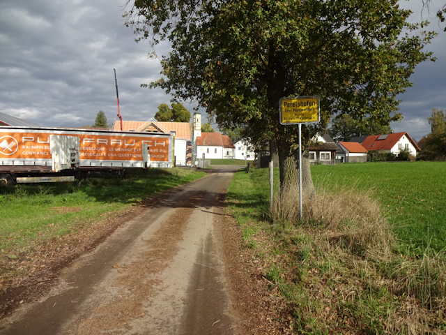
On the other side, my way takes me through the village of Peretshofen ("Shining Raven's Farmyard"), which is located on a little hill on this side of the Maisach...
...and as a result of that I get a downhill view of the town of Mammendorf as I approach.

For the next part, I pass straight through Mammendorf, which is the biggest urban settlement that I have passed through ever since leaving Augsburg today.

It is on the other side of Mammendorf that I have my closest approach to the two windmills, and successively leave them behind me.

Afterwards, I pass by the hamlet of Galgen ("Gallows"), where the Hundehaltungsverordnung ("Dog-Keeping Ordnance") is in effect... on pain of hanging!!! ...maybe. At any rate, I'd take extra care of picking up after dogs here, just to be sure.

Moving on, I next pass through the village of Obermalching ("Upper Messenger's Place")...

...from where I can finally see the distinctive silhouettes of Munich's tall buildings in the distance. That puts me on the victory road now!

But there's still lots to see along the way. For one, I pass by a pasture for pigs, which is sort of a rarity, because normally pigs are held in considerably smaller pigsties instead. These ones have a whole field to dig up all to themselves though. Lucky pigs.

I have already crossed the river Maisach three times today (I crossed it once more in Mammendorf), but now I finally arrive in the town of Maisach. As I do, I note with some concern that the sky has closed up yet again, and wonder if I'll be able to make it back home before rain starts falling once more.

Still south of the railroad tracks from Augsburg, I continue across a field path that runs north of clearly abandoned tracks. In fact, those used to belong to a military base that has since been abandoned and now serves as a little nature reserve.

And, you might have noticed that I did not take a lunch break yet despite being already within sight of Munich. That has two main reasons: For one, thanks to happening upon the gap, I made significantly better progress than anticipated and it is in fact only quarter-to-one now. And for another, I simply did not find any good place to sit down in the whole last hour since I passed through Mammendorf. However, now I finally fin a lone - and thankfully dry - bench next to a skate park where I can sit down and have my lunch, which today comes in the form of a Croissant and, my favorite, a Nussschnecke ("Nut Snail"). Also a Müsliriegel.

After lunch, I continue first along an idyllic garden road...

...and then a less-idyllic and actually kinda busy main road...

...which takes me back east across the Amper, which I last crossed two days ago in Dachau.

Fortunately, on the other side of the Amper I can soon turn onto a significantly more relaxing field path...

...that ends up taking me to the town of Olching ("Alder Place"), which has a cutely edited city sign on the road that I approach by.

Afterwards, a light drizzle begins to fall as I make my way across today's Field Path of the Day. Still a harmless candidate though, although the mud makes it just a little bit more challenging.

Following that bit, I unexpectedly run into a winner of Forest Path of the day. With the leaves covering the ground in a big (beautiful) orange blanket, it's any tail's guess where the actual path runs, and I try to follow what I think is the most likely actual path as best as I can.

And following that, there's a path that looks a lot nicer than it feels, because this one follows an old, abandoned railroad bed. As a result, the path pretty much consists of a rough railroad bed loosely covered with some earth and leaves. One might be okay walking across that, but riding a bike here is, like, super-bumpy, to put it mildly.

I am sure you can imagine my relief when I finally get back to a straight, paved cycling road. Jycily's rims are also quite grateful. And to make things even better, even the drizzle has stopped by now and we're back to clearance.

Shortly thereafter, I arrive in Gröbenzell ("Rough Cell"), which is where I have to turn a little bit to the south again in order to avoid crossing the railway line for a little longer.

There, I notice another Mitfahrbank ("Ride Along Bench"). I didn't realize we had any like that this close to Munich.

After Gröbenzell, there's one last little bit of open country, and then I'm officially back in Munich. Incidentally, kudos to the driver of that white truck that managed to block the entire sidewalk like that! One of these days I need to install a Sonic Breaker on Jycily.

From there, I continue through the idyllic outskirts of Munich by means of not-so-busy roads...

...and eventually cross the railway line at the underpass of Langwied ("Long Meadow"), which is famous for being wide enough to accommodate both a three-lane road and a parking lot and a generous sidewalk on either side. Originally planned as an enormous six-lane road during the time when personal cars were still believed to have a future, it soon became apparent that there was no need for such a big road here then... or ever... so half the road was converted into a parking lot instead.

On the other side, I happen across the Broadway ("Breiter Weg" = "Broad Way"), and follow it back to Untermenzing...

...where I come across one last curiosity: A chicken on the run from the nearby chicken run. Run, chicken, be free!

And that's enough fowl for today. From here, it's only a little longer until I'm back at the Fox Loft, where my two cats Jamie and Toledo are eagerly welcoming me home.

The Road Ahead
What is the new year going to bring? Another big trip, I
wonder? Or maybe I'll get around to finishing the Petal Project in 2023?
Three whole petals are still missing, and the Horse Petal is still broken
(see Book
V ~ Chapter 13 ~ Project Petal Part 8 ~ Alpine Abortion). Anyway,
after this ride I am now momentarily feeling a little bit
better, so that's a good start already, whatever may lie ahead. Well, I am
sure the future will tell, so look forward to the next chapter of the
Travelling Fox Blog. And until then, be of great cheer!