This is the final of the three key destinations of our Germany tour. We are now in the westernmost state of Germany, which happens to be...

Nordrhein-Westfalen ("North Rhine Western Fallow") and since this is a mouthful even by German standards, it is often simply abbreviated as NRW) is the most populous state of Germany counting almost 18 million people, which is about as much as Ecuador, and all that on an area of about 34.000km², which is only the fourth-largest in all of Germany, and roughly equal to the republic of Moldova in eastern Europe. Combine these two things, and it should not come as a surprise that NRW also has the fourth-highest population density after the three city-states, and the highest of the non-city-states in all of Germany. At over 500 people/km², it is about as crowded as South Korea. Its coat of arms depicts a white river on a field of green on the left for the Rhine Province, a white stallion on a field of red to the right for the Westfalen Province, and the red rose of Lippe on a field of white below both of them in the middle.

NRW is also a rather recent and artificially created state. Unlike, say, Bavaria, which dates back to the 6th century, NRW was only created in 1946 after WWII by the British military administration by combining the Prussian provinces of Westfalen with the northern part of the Rhine Province, and then also adding the Free State of Lippe ("Lip"). As such, NRW is more or less a patchwork state that is still struggling to come up with its own cultural identity even three quarters of a century later.

NRW is one of four German states that is further subdivided into a number of bigger administrative districts before breaking it down to a county level. So within NRW, we are now within the Köln district, and within the Köln district we are in the Heinsberg ("Home Mountain") County, the westernmost county of all of Germany. The Coat of Arms of Heinsberg depicts a two-tailed crowned silver lion on a field of red for the town of Heinsberg on the top left, a black lion on a field of gold for the town of Geilenkirchen on the top right, and a red lily cross with a blue flax blossom on a field of silver for the Landkreis Erkelenz.

Within Heinsberg county, we are in the town of Geilenkirchen, which has about 27.000 inhabitants, and is thus already more populous than most towns I've been to in New Zealand. The coat of Arms of Geilenkirchen features a golden, two-tailed lion on a field of blue above a blue parrot on a field of gold. Also, the surrounding geopolitical area is generally interesting, with the narrow Netherland province of Zuid-Limburg ("South Limit Castle") marking the southernmost reaches of the Netherlands.

And finally, within Geilenkirchen, we are located within the district of Hünshoven ("Home's Farmyard"), which is located on a hillside to the east of the river little Wurm ("Worm"), which already reminds me of the similarly named Würm back home in Untermenzing.

So much for where we are now located. Next, I will give you a few details about...
The Place
This time around, we're staying in an apartment once again, and said apartment is located in a little brick building just at the side of the road leading up the defining hill of Hünshoven.

The majority of the place is taken up by a reasonably sized living/kitchen room, which thankfully also features a proper laptop-friendly workspace for me to make use of. After all, these stray maps won't draw themselves, and they are best drawn right after a stray when my memory of exactly which obscure paths we ventured down on is still fresh.

Then, there's a bedroom with two comfortable beds...

...as well as a clean bathroom featuring everything we need.

All in all, this seems like a really nice and friendly location - a fact that is also reinforced by the very key to this place.

A supermarket is also not far away, but you better not believe that we would be able to walk there without coming across a number of curiosities. For one, there's a Statue of Liberty to be found near the station square of Geilenkirchen...

...and then, there's this kinda spooky fountain which I figure is supposed to depict a wood wraith or something.

Also, there's this really short stretch of road that is almost wider than it is long, but still has its own "All vehicles prohibited" sign.

Even in the supermarket, the curiosities don't stop, as they seem to have a very interesting understanding of what qualifies as spices and eggs respectively. Or maybe I've got it wrong? Honey is a spice, right? Oh, and can I have my strawberry jam sunny side up?

And finally, there is a very... uhhh... memorable... feature right outside our house: A railroad level crossing, and for some reason or another, even though it's open, like, 90% of the time, we always seem to run into it while the gates are down, and have to wait for several minutes to get across each time.

Geilenkirchen should yet feature more to see, but we are going to cover that along the various stray we should embark on in the place. And speaking of which: Since we arrived in Geilenkirchen relatively early on the day, we still have time for a short stray...
Up and Down the River
20-Sep-2020Distance: 8.5km
Ascents: 70m
Duration: 3h
6/8🎁︎
Now, normally our first order of business would be to go shopping for groceries, but since today happens to be a Sunday and we're now in a state where grocery shops are closed on Sundays, that's not an option. But don't worry: Since something like that happening at some point on our trip was sorta predictable, we made sure to pack supplies for not only one, but several emergency dinners, and this is actually the first time we have to make use of them. As such, we now have at least a few hours on our hands to go exploring the immediate area. Our stray should lead us first a bit upstream following the hillside parallel to the Wurm, then across the stream and downriver for a bit. Then, we should cross lengthwise through Geilenkirchen until we reach the Burg Trips ("Trips Castle"), at which point we should cross back over the Wurm, and then head back upriver again until we return to our stay place.

Our stray begins which us walking the street up the Heinsberg, which while probably not worthy of the title "mountain" is still the highest elevation we've climbed since our stray through the Jasmund Nationalpark on Rügen (see Book IV ~ Chapter 6 ~ Roaming Rügen).

Soon enough, we leave the road behind us and embark into a nearby bit of forest along an "Are you sure this is a path?"™

Aaand, thanks to the map data on forest paths being obviously outdated, we promptly end up getting just a little bit lost. Fortunately, my forestry skills are by now good enough to help us traverse even this uncharted terrain, and after one last valiant attempt to make our way through the forest itself to the way that is displayed on the map, we just end up hiking across the fields on the forest's edge until we reach a road again.

Fortunately, it doesn't take too long to make our way back onto better infrastructure again...

...and from there, it doesn't take us long to reach the Wurm, which is really only a stream roughly the same size of the Würm back home. How nostalgic!

There's even a moderately sized biotope called the Wurmauen which totally reminds me of the Würmauen back home (though this one is bigger). Talk about similarities!

It is also here that we come across a bench that must be very Green-Shnolz-regulations-compliant, because I honestly can't imagine taking any sort of extended rest on that uncomfortable thing (Or is it art? I can never tell).

Afterwards, we enter the town of Geilenkirchen again, passing a street named "Am Sonnehügel" ("At the Sun Hill"), which is quite sunny, and also atop a hill. And while the hills around here are by no means challenging, they are still a welcome change after the comparatively flat lands of Sylt and Bremen.

We also come across a massive Geocache hidden in plain sight. Disguised as a grit bin, it serves as a travel bug hotel with ample space.

There's indeed quite a few travel bugs inside there, so I have to decide on one. Meanwhile, since I've also managed to swap two other travel bugs in Bremen, the one I have to leave behind here is already the Globetrotter Mouse I found on Sylt (see Book IV ~ Chapter 8 ~ Sylt Stray Sillyness), making this the shortest I've ever held onto a single travel bug with only 5 days.

Moving on, we pass a garden with horses grazing right there in the middle of the town...

...and then proceed to climb the highest hill we've seen since Rügen.

Soon thereafter, we reach the end of Geilenkirchen, and with it also the end of the world, because apparently there are no towns beyond this one.

We walk beside the road upon a path paved with the portenders of impeding autumn...

...and when we cross back over the Wurm again, it is where the little river supplies the moat of Burg Trips, an aquatic castle originating in the 14th century. Originally a classical castle surrounded by a moat, it was gradually and repeatedly remodelled over the centuries until it gained its present manor-like characteristics. Today, part of it serves as a retirement home, but the main keep is still vacant.

From there, we continue east, back towards the railway line, coming across another of those green algae-covered ponds, just like back in Bremen. There seem to be an awful lot of them in the northwestern part of Germany.

We cross the railway tracks in the village of Süggerath ("Swampy Council"), and then head back south towards Geilenkirchen along a country road. There's no sidewalk here, but fortunately this road is nowhere near as busy as the dreaded car-car happy road of Bad Schandau (see Book IV ~ Chapter 2 ~ Scaling Saxon Switzerland's Serene Slopes).

Eventually, we come across a small and even less busy sideroad that we can walk instead, and so as the sun gradually sets we come closer and closer to our home base.

However, shortly before we do we should come across a nearby pasture with a pair of horses, one of which is quite energetic and restless, galloping around the pasture and rolling in the grass. I've already observed this behaviour back on Thornton Grange in Christchurch (see Book I ~ Chapter 12 ~ Christchurchly Second), but this is the first time I should actually be able to capture it in a video.
And finally, we arrive back at our home just in time to see the sun set behind the houses.

That was already a nice first stray. Next, we should head out as far west as it goes. But before that, let's briefly talk about...
The Food
Breakfast around here contains of bread with cheese. And yes, I know, we've had this already. But think about it: There's so many different kinds of bread and cheese that even with just what's available at the local supermarket, you could be eating a different combination for years without repeating yourself... hmmm... (starts drawing up a spreadsheet... a cheese-spread-sheet).

Once again, lunch is always eaten on the road. But in the evenings, we should cook up delicious meals. The first dinner is somewhat simple since it's Sunday and the stores are closed, so we rely on one of our emergency supply dishes, which happens to be plain but tasty pasta with tomato sauce.

Our second dinner should be more hearty. Using a full 75% of the stove's maximum capacity, I whip up a vegetarian version of Gamm Ligeral, substituting the meat with more mushrooms, and creating a tasty and savoury dish with tomato sauce and Parmesan on top (which sounds so much better than "the same as yesterday but with extra mushrooms and cheese").

And the dinner on the third day should be appropriately legendary. Maybe you already noticed it, but this kitchen has a fully functional oven again, and since it's already been close to a week we use this chance to make legendary tri-Tail pizza once again.

Also, as an added bonus, we also found some dried Steinpilze ("Stone Mushrooms" = "Boletuses") in the supermarket that we can add on top to make the pizza extra-tasty. As an added bonus, they are from the Rheinische Pilzzentrale ("Rhinean Mushroom Central"), which I guess even makes this a local speciality of sorts.

So much for the food. Now, we are ready for the final of our three cardinal strays, namely...
The Western Endpoint Undertaking
21-Sep-2020Distance: 28km
Ascents: 70m
Duration: 7.75h
7/13🎁︎
Today, we embark towards the westernmost point of Germany, which is still located approximately 21km away from Geilenkirchen, with Geilenkirchen having been the closest place with a railway connection. As such, it is only within borderline one-way walking distance, and this time around we won't be able to make a relaxing bicycling tour there either - and certainly not because Robert threatened to horribly murder me if I propose another biking tour; the very thought is absurd. No, the main problem is that there are simply no bike renting places in Geilenkirchen. So, instead we settle on taking the bus to the village of Tüddern ("Tooting") and walk from there, which frees up the majority of the day for a relaxing stray through the Netherlands, which at this point in time are conveniently not a Green Shnolz risk area (I checked). Afterwards, we should manage to walk back all the way to Gangelt before taking the bus back to Geilenkirchen. Incidentally, this should also be the longest stray of our journey, and one of the longest strays of my life. The last time I completed an even longer stray was during my final great stray in Japan through Kawasaki and southern Tokyo (see Book II ~ Final Chapter ~ Of Spirits and Shrines).

We embark at 9:00, mostly because as mentioned before yesterday was Sunday, and we had to go shopping for our breakfast in the morning, and even with the supermarkets opening as early as 7:00, that still means we won't be able to comfortably catch an earlier bus. By the time we depart, the outside temperature is at a comfortable 15°C, though it should get much warmer as the day stretches on.

Our first stop is - naturally - the bus station, where we have to tolerate the presence of a follower of Öchött'Kjött, God of Vile Vapours and Lung Diseases, for some time until the bus finally arrives.

The bus itself, however, is quite empty, and we the two of us already make up for about a third of all passengers.

The ride to Tüddern should mostly take us past the many sprawling fields surrounding Geilenkirchen while passing through a couple of smaller towns, but we also pass through a few stretches of forests and also get to see a few windmills on the northern hills.
Soon enough, we arrive in Tüddern, which is really just a small village. Notably, even here the houses are predominantly still built out of pure brick.

From here out, we should first be heading northwest towards the westernmost point of Germany, zig-zagging across the fields as necessary, and then head over into the Netherlands. Once there, we should head south through the village of Nieuwstadt ("New City") and the town of Sittard ("Shivers"). From there, we could have simply returned to Tüddern, but instead we should chose to keep on walking all the way east through Süsterseel ("Sweetest Soul") and should manage to continue walking all the way to Gangelt ("Walk Money"), which is effectively already halfway to Geilenkirchen again.
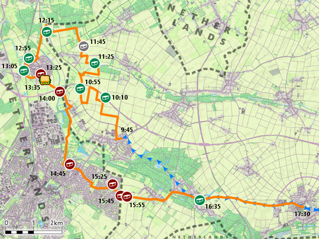
Within a few minutes, we have already left Tüddern behind us and are on our way. The first thing we come across is a roundabout which explicitly leads into three different directions: Left, right, and straight ahead.

From there on out, we start hiking through the fields, sometimes along major roads, and sometimes on field paths.

Interestingly, one of these fields is used for growing racoons. I wonder how many people know that raccoons are actually vegetables that go through a leafy green stage before developing their distinctive black-and-white stripes and facial masks.

Also, we are now so far to the west that the normally green bicycle route signs have changed color due to the red-shift phenomenon.

As we cross over a highway of sorts, we can already see all the way to the Netherlands, which as so often beginn at a little river, distinguishable only as a line of trees at this distance. Incidentally, while there was some hilly terrain around Geilenkirchen itself, this particularly area is rather flat, which I suppose makes sense, what with us just about to enter the Netherlands ("Lower Lands") and all.

But before we get there, we still have a bunch of fields to cross through. By this time, maize and a number of root crops are pretty much all that's not harvested, and more and more trees and bushes are gradually starting to change color for a more autumn-like look.

We also have another close encounter of the equine kind (and I suppose the prevalence of horses in these parts can be attributed to the flat lands being perfect for riding)...

...and subsequently have some pastures to add to the list of landscapes we hike through today.

Eventually, our hike takes us to the westernmost village of Germany: Isenbruch ("Iron Quarry"), which is not to be confused with Isengart ("Iron Guard").

From here on, the westernmost point of Germany is not far, and there are even signs pointing the way.

However, instead of going straight through Isenbruch and risking picking up several souvenirs, we take a roundabout route in search of more Geocaches. Unfortunately, due to some fiendish design or something, all the caches around this area seem to implement the squirrel-pattern.

Subsequently, we pass to a little bit of yet-lush forest...

...and then, we arrive at the westernmost point of Germany, which incidentally is clearly the best developed of the three extreme points we've visited, complete with info boards, benches, rainshelter and all.

Thus, we now have visited three out of the four outermost points of Germany, which should be all we would get on this particular journey. The last one - the southernmost point - is actually quite close to Munich, meaning we could probably go get it on a weekend trip sometime.

Anyway, thanks to aforementioned info boards, we also learn a few interesting things. For one, this place has not always been the westernmost point of modern day Germany. In fact, up until 1963, the area known as Selfkant ("Shelf Edge") was officially belonging to the Netherlands as a war reparation collateral, and was only returned to Germany after a total of 280 million DM had been paid (today, this would be the equivalent of roughly half a million €). Maybe the most interesting event here was that at the night of the Selfkant's return to Germany, countless tons of tobacco and coffee were smuggled across the border without moving: Clever citizens had in advance stocked their homes and barns and sheds with these wares (which were considerably cheaper in the Netherlands), and when the border moved at midnight of 1-Aug-1963, all that coffee and tobacco was suddenly on German ground, without the need to smuggle it past toll inspectors or paying even a penny of import tax. However, even before that day, the westernmost point of Germany was still at this general area, approximately 6km east of here near Saeffelen ("Sheep-ling").

We also learn that we are right now at the narrowest stretch of the Netherlands, with only a measly 4.8km of Netherlands separating Germany from Belgium at this point.

However, despite Robert being very, very insistent on that we go and make our way to Belgium at this point ("Beeeelgieeenn~~~"), I decide against it, mostly on account of the tiny little fact that after crossing those 4.8km, we would have to swim across the Maas to get to Belgium, since there does not happen to be a convenient bridge at this narrowest point... or in fact anywhere near it. Without that river in the way, it would have been a valid option to hike there, quickly pop over to Belgium, and then walk back to Tüddern instead of continuing all the way to Gangelt. However, with that river in the way, things are different, for while it's only 4.8km to Belgium from here as the dragon flies, it would still be about 7.5km as the Kori (狐狸 "fox and tanuki") walk, and then we would end up in the town of Maaseik ("Measure Oak"), which is way off our planned course. Plus, we would probably have ended up walking mostly along major roads on account of me not having scouted out scenic routes in advance.

Meanwhile, crossing over into the Netherlands is remarkably easy. All we have to do is walk across a cute little bridge...

...and then we're in the Netherlands, which are at first glance not all that different from Germany.

And yet, it becomes blatantly obvious that we are now in a different country as soon as we come across the next farm, which turns out to be a Kinderdagverblijf ("Children Day Care"), though it is actually impressive just how much Dutch I can actually make sense of, what with the language sharing a common root with German and being actually quite close. Like, I can immediately tell that a German literal translation of "Kinderdagverblijf" would be "Kindertagverbleib", which is not a word any German people would ever use, but still be able to make sense of.

Naturally, that translational prowess still has its limits. For example, I have absolutely no idea what an appropriate translation for this road name would be.

Another curiosity we come by are these weird diagonal waste baskets. We're still not sure exactly what the purpose of this design is, though my guess is that you can better throw waste into them while cycling by on the nearby cycleway.

Before long, we cross the Vloedgraaf ("Flutgraben" = "Flood Trench"), which would be just another little stream, if not for the fact that the river grass at its bottom makes it look almost like a pastel painting.

A little bit later we reach Nieuwstadt De Nuujstjadt, which poses a bit of a linguistic conundrum. Just from looking at it, I would have guessed that both "Nieuwstadt" and "Nuujstjadt" would be the equivalent of German "Neustadt" ("New City"), but then why are there two different words for it? The obvious conclusion would be that one of the two means something different, but with linguistics being what it is, it could also be that both mean the same thing in different dialects. Assuming that to be the case (which also makes it more funny), this would translate into something like "New City at New City".

Apart from linguistics, we also learn other things. For example, unlike Germany, the Netherlands appear to have shared roads for both bikes and small mopeds.

And then, we apparently totally lost our way since instead of Nordrhein-Westfalen, we end up in Bavaria again.

Fortunately, we come across a nice, remarkably two-dimensional soccer-tennis ant man who opens up a portal in space-time to set us back on the right track again.

Now, remember when we went to Poland and found everything was kinda crappy (see Book IV ~ Chapter 4 ~ Görlitz Gaiety ~ Eastern Escapades)? Well, the Netherlands are the complete opposite! Here, everything is clean and clear, and in a state of perfect repair. This makes Germany look like Poland by comparison.

However, I also take note that the Dutch (at least in this area) really seem to hate lawn mowing, but maybe that's because of the Drempels (whatever those are).

Anyway, soon enough I find my first Dutch Geocache in a Zwerfboekstation ("Zwergbuchstation" = "Dwarf Book Station" = "Community Book Exchange"), where the logbook is ingenuinely disguised as... A BOOK! Talk about hiding a tree in the forest!

Walking through the roads of Nieuwstadt De Nuujstjadt, we also come across some weird road markings unlike anything I've ever seen before. I wonder what they mean...

We also pass by a deer orchard. That's right. Because if you've got both deer and and orchard, why don't keep one inside the other?

And did I mention that Dutch sidewalks are somewhat more classy than their German counterparts?

However, for all their clean perfection, there's one thing that's distinctly lacking and becoming quite bothersome, and that are benches to rest on. In fact, we have to keep on walking all the way to the far side of Nieuwstadt De Nuujstjadt before we finally find a bench that we can rest on and eat lunch, which in my case is a humble cheese bread, and in Robert's case a hearty portion of "I ate my lunch during breakfast". The bench is also nice and shady, which is a boon since the temperatures have actually gotten quite hot by now, and wanting to avoid a second dose of sunburn, Robert and I use this opportunity to put on another layer of sunscreen.

At one crossroad we come across these interesting tiny ramps, which I guess might be for preventing cars from parking there? I'm actually not really sure. Another mystery of the Netherlands.

Finally, we pass through a Grondwater-Beschermungsgebied ("Grundwasser-Beschirmungsgebiet" = "Ground Water Shielding Area" = "Ground Water Protection Area")...

...and then, we're already leaving Nieuwstadt De Nuujstjadt behind.

A little down the road, we cross over a spectacularly dysfunctional deer grate, which not only has its pedestrian gate permanently open, but also two steel sheets over the actual grate, and no fence to either side. It doesn'T get much more dysfunctional than that, though I suppose the grate could still be filled to the rim with earth or something.

During this stretch, we should actually stitch back and fort between the Netherlands and Germany for a bit, passing over the little Rodebach ("Red Brook") that serves as the border.

There aren't even any border signs around here. The only signs that make it clear in which country you are are the "Forbidden for cars and motorcycles, with the exception of agricultural vehicles" signs.

An interesting way to passively enforce these signs are actually these road blocks that we pass by, which allow for tractors to pass over them, but not cars. And I guess monster trucks can pass over those as well, but then, those can pass over pretty much anything smaller than a minivan.

From there on out, we have a peaceful and thankfully mostly shady hike across the countryside, and eventually end up on the Quix Pad.

And just like that, we have stealthily made our way into the town of Sittard, and we should still stay surrounded by green for some time since there's, like, a whole series of parks so you can cross half of the town without having to venture too far from a patch of greenery.

Among those parks, the one that is most memorable to me is the Park de Baandert, with its series of signed footprint panels. I wonder what their story is. Yet another mystery of the Netherlands...

Meanwhile less mysterious is this wastebasket, which is also for dog poo.

And then, there's also this unusual crossroads where apparently two opposing curves were later on connected in such a way as to make sure that only normal-sized cars but not SUVs or trucks could go straight at this unorthodox junction.

Staying on the topic of interesting crossroad designs, there's also the really nice option to have round speed bumps of sorts at every junction, which is actually a pretty clever idea for residential areas, if you ask me.

And if you don't like that, then there's also the option of what I'm gonna call the bike-friendly speed bump.

By now, we have crossed through all of Sittard - which is apparently also known as "Zitterd" in some dialect - and are now leaving the city...

...and with it all of the Netherlands and the region of Zuid-Limburg behind...

...returning to Germany and the state of Nordrhein-Westfalen once again.

From here on, the way should be relatively straightforward, as we effectively just walk along a straight road, which is thankfully not very busy and has a separate sidewalk for pedestrians.

It's mostly uneventful, though while passing through the town of Süsterseel (which we past through by bus earlier) we do come upon a pumpkin sale in a farmyard.

Now, we could just wait here for the bus back, but since we naturally just missed the most recent one, we instead figure that instead of just standing around we can also keep on walking all the way to Gangelt, which effectively means another 4km of hiking along a more or less straight road across fields.

By the time we finally reach Gangelt, I am quite exhausted, and although Geilenkirchen is by now within extended walking distance (read: 10km), there's absolutely no way in Lerra that I'd be able to pull that off today. Also, more importantly, it's already getting late again, and with Equinox just a day away we'd be arriving in the dark if we kept on walking now.

As it is, walking through Gangelt to the bus station is already enough for me, and along budget-sidewalks no less!

But, as a result we still get to see the swan fountain in front of the old city hall...

...as well as the impressive St. Nikolaus Kirche ("St. Santa Claus Church").

After that, we finally reach the bus stop...

...and before long the bus to Geilenkirchen already arrives, what with us having used up almost our entire lead with the hike from Süsterseel to here. Once again, the two of us make up about a third of the passengers on the bus.

This bus also features a stylish codex of manners asking people to be more considerate, and specifically to "keep it down", "stay clean", "stay down" and "keep it to yourself".

The bus ride once again takes us across fields and through villages, and before long we're back in Geilenkirchen again. Still, walking this distance would have taken hours.
As such, we arrive back in Geilenkirchen before just sunset, and I for my part are quite exhausted and thankful that it's only a short walk from the bus station to our stay place.

With that, today's stray is coming to an end. And now, although we still have one full day left here in Geilenkirchen, let's quickly do...
The Retrospective
This was a nice enough place to stay at. We had our own completely private apartment, some food supplies, and the place was nice and quiet and had a kind host. The beds were a bit of a drawback though, because while they were reasonably comfy, they made noises every time one of us turned over in the night. Having a bathroom as part of the room was nice too, though the shower had a little bit of a temper. Location-wise, I don't think it could have been much better. The place was close to the station and had good shopping options nearby. Also, we had our own kitchen, the temperature was comfortable, and the free WiFi worked fine at least most of the time. The price was a little bit expensive though, because we had to pay about 27€ per night and nose, making it our second-most expensive stay after Sylt. For what was offered, I think 22€ would have been adequate. Or maybe having free bikes. Overall, that averages out on a place score just a little bit above that of our stay place in Bremen.

With that ticked off the list, we now have one more stray to cover, namely...
The Equilateral Equinox Expedition ~ Of Chapels, Crosses and Churches
22-Sep-2020Distance: 21km
Ascents: 110m
Duration: 6.25h
7/9🎁︎
Today is a very special day for me. It's one of the four solar festivals, and maybe the most loaded one for me: Autumn Equinox. Two years ago on this day, I scaled mighty Mt. Daisen in Japan (see Book II ~ Chapter 13 ~ Daring Daisen), and four years ago on this date, I was straying around Oakura, New Zealand (see Book I ~ Chapter 3 ~ The Oakura Factor) on one of my first few strays in the land of the long white cloud.
Incidentally, this stray should approximate an equilateral triangle, with the endpoints at Geilenkirchen, the hamlet of Panneschopp ("Pan Shed") and the town of Windhausen ("Wind Housing"), and should take us past quite a few chapels, crosses and churches. Also, after returning to Geilenkirchen, we would be spending some more time straying through the town in search of souvenirs, having not found any keychains or magnets thus far. But alas, this should stay the one place of our Journey from which I should bring home nothing but pictures and videos.

Once again, we depart in the morning, and once again the weather is sunny. Come to think of it, we didn't have a single day of bad weather during this entire journey thus far, which is actually really amazing.

Now, since we're in Geilenkirchen and all, I figure wed should at least try and make a point of visiting a few of its churches today. First of those there's the Evangelische Kirche Geilenkirchen ("Protestant Church Horny Churches"), which is located just a short ways away from our stay place.

After that, we come across an interesting project: An anti-nuclear power demonstration pole, where you can cast a vote for the shutdown of the Belgian nuclear power plant Tihage, which is located approximately 75km to the southwest of Geilenkirchen. Votes are forwarded to the Belgian government on a weekly basis, and probably make a beeline to whatever ministry's spam folder. Still, I think it's a nice idea, and definitely generates publicity. Unfortunately, the website mentioned on the pole is no longer operation. I wonder if they had a hand in that?

Only a short ways further, there's the church St. Mariä Himmelfahrt ("Saint Mary's Ascension"), which is yet another Gothic brick church...

...and then we should walk a bit through Geilenkirchen before coming across the next church, preferring scenic little footpaths over the roads.

Somewhere in the backroads of Geilenkirchen, we end up coming across what must be the narrowest sidewalk I've ever walked on...

...as well as a very interesting design for a gutter drainage pipe.

But now for more churches, here's the Neuapostolische Kirche ("New Apostolic Church"), which is notable for not featuring a bell tower.

Also, there's a bunch of dog sculptures lying around beneath a willow tree nearby. In the shade and especially beneath the tree, it takes two looks to tell they're not real.

Now, as for a landmark of Geilenkirchen that can be seen from quite a far distance away, there's the Wasserturm Bauchem ("Belly-um Water Tower"), an almost 50m tall three-tier tower built in 1949 in the style of Brick Expressionism (aka: bricks are cool).

By now, we have pretty much reached the town border of Geilenkirchen, and upon leaving the town behind us we come across the reason why we could not go any further west by train. Originally, the Selfkantbahn ("Shelf Edge Train") - a 1000mm narrow-gauge train - was operating between Geilenkirchen and Gangelt starting in 1969. However, due to too high operating costs, the endeavour only lasted for four years, and ever since then there is only the occasional museum train running between Gillrath and Schierwaldenrath ("Sheer Forest Council"), with most of the tracks having been scrapped, apart from some leftover level crossings like this one.

Literally just on the other side of whatever little is left of those tracks, there's the Kunigunden Kapelle ("Kunigunde Chapel"), which incidentally also serves as the hiding spot for a Geocache. This little chapel was only built as recently as 2012.

After that, we continue down a cute cross-country road...

...pass a pasture of ponies...

...and soon enough arrive at the Wegkreuz in der Dell ("Way Cross in the Dent"), sheltering beneath a lush grove of trees. This would be the perfect place for a lunch break. Unfortunately, it's only 10:00 by now. Also, it appears that we inadvertently have ended up on a pilgrim's path. I wonder how many more stations of this path we should end up running into today. I would, in fact, not be at all surprised to find that several more Geocaches have found hol(e)y hiding places like these.

Anyway, next we pass through the hamlet of Nierstrass ("Kidney Street")...

...before arriving at the Wegkreuz am Bach ("Way Cross at the Brook") on the other side.

As expected, there's a Geocache near this one too, though I have to admit that this one is hidden in a rather clever way.

After that, we pass over today's field path of the day (this one being rather tame compared to some other things we've been through)...

...subsequently arriving in aforementioned hamlet of Panneschopp, one of the corners of our stray.

Unsurprisingly, there's another chapel with a Geocache here, this one being the quite straightforwardly named Kapelle Panneschopp. Incidentally, am I the only one who thinks it's kinda weird to have a picture of the chapel on the board that's attached to the chapel itself?

In this hamlet, a donkey and a dog stand eternal watch as gate guardians for a local farmstead...

...which has live cows lazing around on a nearby field. And since the temperatures are again already rising rather rapidly, the placid bovines have retreated to the shadowy side of the pasture.

Leaving Panneschopp behind, we pass by the NATO airbase Geilenkirchen, which is fittingly located almost exactly at the border to the Netherlands. In fact, the air base is pretty much already a small town in its own regard.

Incidentally, we arrive come just in time to witness the takeoff of an old Boeing E-3 Sentry, which apparently blows more dirt into the air in one start than an indigenous family would over the course of their whole lives. Seriously, the amount of dirt it blasts right in my face is extreme, and I should have to wash up after returning to our stay place. Had I known that in advance, I would not have stood directly behind it (and with directly I mean about 200m away). Modern airliners are just so much cleaner than this, which I guess goes to show we've come a long way since.
After passing the airbase, we enter the village of Teveren next, which actually seems quite big after these last two hamlets.

Within that village, we come across the Kreuzfahrt-Beratungsmobil ("Cruise Trip Advisory-Mobile") of the Reisebaron ("Travel Baron"), who I guess must be hitting on lean times right around now, what with the Green Shnolz and all...

We also pass by not one, not two, not three, but a total of four wayside crosses within that village, plus two churches: The St Willibrordus Church and the Protestant Church Geilenkirchen-Teveren. And nothing against Christianity, but have I mentioned that I find it kinda depressing to have effigies of corpses hanging around all over the place?

On the countryside again, we soon find out that not only the Netherlands have road markings that are not immediately intuitive. If anyone knows what these mean, please contact me.

The next town we come across is actually already the southern cornerpoint of today's stray. It is the district of Windhausen of the town of Übach-Palenberg ("Obrook-Shell Mountain"), which also features an interesting road pattern at its entrance. I figure at one point in time there was a pole here to separate the walking/cycling path from the main road, but apparently it got removed as cars got bigger.

There, we come across a house that I find particularly appealing for some reason. Maybe it's the combination of orange and black, the shape, or the solar panels on the roof. Either way, I kinda like this design.

We also enter the Willy-Dohmen Park, which apart from more lush trees than we came across in the last hour or so also has an interesting code of conduct. Specifically, swimming, smoking, fishing and hunting is not allowed. Loving, meanwhile, is permissible. I wonder how many that last missive has been stretched to the point of breaking.

Maybe the most important part of the park, however, is that half of it is on the high ground overlooking the Wurmtal below us, so from our vantage point in the park we can get maybe the closest thing to an actual panorama in these otherwise still rather flat landscape.

Leaving the park behind by means of a not-at-all unorthodox way, we arrive at the nearby Kapelle zur Schwarzen Mutter Gottes ("Chapel to the Black Mother of God" = "Chapel at the Black Madonna"). Incidentally, it has been some time since last we've found a Geocache at these chapels. I suppose we must have left that pilgrim's path behind somewhere around Panneschopp.

Anyway, from here on out, it's downhill all the way to the valley ground. At a gradient of about 7%, this road would be fun to ride down by bike, but not exactly pleasurable to go up.

On the lower end of the hill is where the district of Zweibrüggen ("Two bridges") begins...

...and also where another wayside cross is standing around. This one audaciously asks us to pray a Pater Noster.

Shortly thereafter we cross the Wurm via one of Zweibrüggen's two bridges...

...and take a moment to watch the waterfowl at the nearby Wurmtalsee ("Worm Valley Lake"). Most of the birds are geese on the far side, but there is also a loon quite close to our side.
It is also here that we finally find a nice and shady bench on which we can take a break, me eating my lunch, and apply more sunscreen for the two of us.

After that, we head north and continue walking back towards or stay place downstream along the Wurm.

Along the way, we come across a bridge that is old. As in, really old. As in, really really old. As in, so old that it has actually collapsed and all that's left are the foundations on either side. However, it appears to have collapsed only recently, for it is still marked down on my OpenStreatMap-based map. As such, I make a point of updating this little detail once we get back.

The next town we come across is Frelenberg ("Frief Mountain"), which naturally also comes with its cross and church, the later being the St. Dionysius Church.

This town also has a local mascot: The Frelenberger Esel ("Frief Mountain Donkey"). According to local legend, the citizens of Frelenberg, unable to agree on where to built their church, decided to let a donkey decide for them: They put a bag on the back of the donkey and decreed that they would build their church wherever the donkey threw off the bag. And what did the donkey do? Instead of just throwing off the bag anywhere nearby, it started climbing a nearby hill and only threw off the bag at the very top when it lay down after an exhausting climb. True to their word, that's where the citizens ended up building their first church.

And that's the last town on our way. After this, we should continue through the greenbelt for about 2 more kilometres more or less along the railroad tracks...

...before finally arriving back in Geilenkirchen again.

Once there, we should embark on aforementioned bonus round, looking for suitable souvenirs to take home. However, we should not really find anything, apart from maybe this really cute cardboard fox in a store window.

Also, that's not a spoon...

...that's a spoon.

In the end, the best we should be able to find is a rather modest post card, but that's still better than nothing. At least on this one we can see how aforementioned Selfkantbahn looks.

After that, we return home to make pizza, and just as we cross the station square of Geilenkirchen once more, the old Boeing E-3 Sentry that we saw take off earlier at the NATO airbase is passing directly over our heads, its jets still as dirty as ever. I guess this one is also returning to its home base right now.

With that, this stray is now finally coming to an end. At least for me, because Robert should still accept a quest from me and go hunting for souvenirs some more while I update my maps. Unfortunately, he should not be any more successful than we already were. Oh well. Anyway, now all that's left is...
The Road Ahead
And that's it for our stay here in Geilenkirchen. With this, we've got all the major destinations down. And yet, we still have time for one more stop on this vacation, so we're up for one more place to visit on this journey. That place would be the city of Trier, and you shall read about our journey there in the next chapter of the Travelling Fox Blog.