Having just seen my best friend Robert off at the New Chitose Airport, I return to Sapporo by train. Now, I have made arrangements to stay with a HelpX host in Sapporo starting from the 1st of June, which means that given how busy the last month was and how far behind I’m with my blog. What would do the most logical thing to do?

Right, with that having been decided, my next port of call is the Sapporo Station…

…where I get myself tickets for the Limited Express “Lilac” to Asahikawa (旭川 “Morning Sun River”)…

…and also make short work of the chocolate foxie I purchased back at the Chocolate Factory of New Chitose Airport. And let me tell you, it is absolutely delicious!

Since Hokkaido is rather big, I won’t be making the trip to the very north in a single day. Being the second-largest island of Japan, as well as the 21st-largest island in the world, Hokkaido is just a little bit smaller than Ireland. Overall, it is pretty mountainous, with a few open valleys and plains between mostly forested hills and peaks. It is dominated by a mighty dividing mountain range running from its southern “fin” almost all the way to the north, with its highest point being Asahi-Dake (旭岳 “Morning Sun Peak”) to the southeast of Asahikawa with an impressive height of 2991m. The area to the west of Sapporo is also notably mountainous, which is probably the main reason why the train route from Hakodate is taking such a roundabout way in getting to Sapporo.

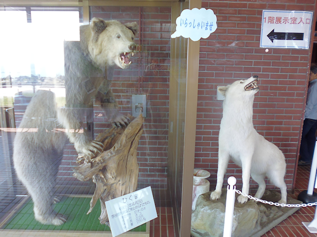
In fact, the Hokkaido Museum had a huge painting of Hokkaido on display that – while greatly exaggerating many details – still captures the essential points of Hokkaido’s geography quite well. The three prominent cities in the centre of the painting would be Sapporo (left), Asahikawa (top) and Obihiro (bottom, 帯広 “Broad Belt”).

Now that you know your way around this Island, it’s time for me to proceed to 1st base and take a trip…
Around Asahikawa
24-May-2018 – 27-May-2018
My Journey begins with me getting in the “Lilac” Limited Express, which is just as comfortable as the Super Hokuto which Robert and I took to get to Sapporo from Shin-Hakodate. This time around, however, I did not pay extra for a reserved seat, and rightly so: The car with unreserved seats does not even get close to half-full.

There are a few perks to taking a Limited Express: For one, the seats are more comfortable and better suited for looking out of the windows. And for another: You usually don’t have to change trains. Going with regular trains would not only have taken at least twice as long, but also would have required me to change trains at least once – depending on the connection. Normally, I wouldn’t have minded, but since the day is already half over after dropping Robert off at the airport, I decided to take the direct route this time around.

Thus begins my journey through Hokkaido, across the farmland surrounding Sapporo, and eventually through the mountains to Asahikawa. One thing that soon becomes apparent is that rice fields – while still existent – do not seem to be quite as ever-prevalent here as in the south.
Before long, I arrive in…

Located as close to the geographical centre to Hokkaido as one can get without building on top of the mountains, Asahikawa is pretty much the crossroads of the island, and thus makes for a logical stopover station for going pretty much anywhere. It is here that I should stay in the most ramshackle accommodation yet, namely the Yumin (遊民 ”Workless”) Backpackers…

…which is at the end of a “house-tunnel”…

…that in turn is located in a driveway of a little side street, with no sign to point the way. Needless to say that it takes me quite a while to find it.

Since Arasawa-san – the woman running this place – is working as an English teacher during the day, I have been instructed of where to find the key and let myself into what turns out to be a little back-alley bar with a few guest rooms upstairs.

And speaking of stairs… these turn out to be one of these models that are excessively fun to climb while lugging two heavy backpacks. It’s been some time since checking into a hostel has been this interesting.

The room, however, turns out to be quite nice. It may lack certain commodities such as a table, but I manage to make myself comfortable, and although I booked it as a dorm room I end up having it all to myself during the four nights of my stay.

It may be because of Robert’s lingering influence, but something drives me to go out after making myself comfortable and exploring the surroundings. In my defence, it should only be a short one.

Short, though by no means lacklustre. For one, there are quite a number of naked statues around. This – as Arasawa-san should tell me later – is owed to the fact that this part of Asahikawa used to be a brothel district in the past.

Then, there’s also a little Inari Shrine only a short ways from the hostel, and though no foxes stand guard outside, a curious peek reveals that a pair has taken up refuge within.

Also, there’s Tokiwa Kouen (常磐公園 “Ordinary Cliff Park”), featuring a lake with a fountain, an observatory, colourful flowers, and even a little island refuge.

But by now it’s already getting late, so I return back to the hostel to what should be my first evening alone in three weeks.

There, I make use of the hostel’s humble… uhh… kitchen…

…and prepare myself a humble meal of cup-yakisoba. This specific brand actually comes with a satchel of miso that you can use to make yourself some soup by pouring the water out of the cup and into a bowl – which makes it a budget Hokkaido specialty, as I should learn later on.

As a compromise between working on my blog, exploring the area and actually making some money, I should spend one of the three days of my stay here on each. Now let me tell you in excruciating detail all about the exciting computer work I got done here.

Just kidding. I know it’s my explorations that you are curious about, and as chance would have it, Arasawa-san should generously provide me with a bike that I would make good use of.

This cute little vehicle is actually a bit small for western-sized people such as myself, but through a combination of curiosity, excitement and sheer force of will, I still manage to take it around an impressive 66km ride around the eastern valley of Asahikawa.

The interesting route this ride should take is the result of nearby Geocaches – of which I should find but a single one – and Shrines. Fortunately, the Shrines are considerably easier to find than the Geocaches.

Incidentally, it is at one of said Shrines – the Asahikawa Shrine itself to be exact – that I should take a break to take in not only my surroundings, but also the songs of the birds of Hokkaido, which are once again rather unique.
Soon after, I should pass some very cute roadblocks…

…and embark on a Japanese Country Road for the first time in my life.

One difference that catches my eye right away are the roadside arrows. These fulfil the same purpose as the roadside posts in other countries, but have the added advantage that they can’t be hidden by grass or bushes… at least not without the aid of a mad botanist.

Anyway, the countryside of Hokkaido is really quite idyllic, and reminds me just a little bit of New Zealand. The rice fields make all the difference though.

By the way, have you ever been in this situation? You really want to build a Shrine, but all you have is a rock and three logs? Well, worry not! Just make a Torii out of the three logs and put it in front of the rock, and Bam! Instant Shrine!

Eventually, I reach the point on which I have to climb a pass between two valleys, and although the pass is not very high and my bike has a whopping 6 gears, the gradient is too steep for it to overcome, so I end up pushing it across.

Much to my surprise, I inadvertently run into something which appears to be a mix between a festival and a flea market on the other side of the pass. There’s even a band performance going on, and it’s all for free!
Interestingly, there are some unexpected familiar sights around that I would not have expected to see on a Japanese flea market.

But anyway, for me the most delightful part about this find is that I can take a little lunch break and gobble away at some tasty Hello Kitty Yakiudon.

After that, my ride continues along a really long and linear road through rows of rice fields…

…the most notable thing about which is a vending machine right in the middle of nowhere.

My ultimate turning point should be the Higashikagura Shinrin Kouen (東神楽森林公園 “East God Entertainment Forest Park”), which should turn out to be a lost world of sorts.

From there, I should follow cycling paths and flowerful roads all the way back to Asahikawa.

Back at the city, I come across a curious boat in the middle of a pedestrians’ street…

…and since it’s already getting late by now, proceed to go shopping at the local supermarket-megaplex…

…which also features an extensive bicycle garage.

Afterwards, it’s back to the hostel, where Arasawa-san has prepared a meal for me as a special treat since I'm staying for four nights. It’s a tasty plate of Paella… or at least something Paella-inspired that is still delicious and steaming hot – which is good since the nights here in Asahikawa can get quite chilly.
Arasawa-san is a really kind host, and that makes all the difference. Thanks to her amicability, this little hole in the wall becomes a proper home for the days I should stay here, and it feels less than a hostel and more like a homestay. Most importantly, however, Arasawa-san should let me in on a juicy piece of really important information that I would not have come across otherwise, and that should change my future travel plans. But more about that in Chapter 8. For now, let me tell you a bit about some of the curiosities I found in Asahikawa, such as a noisy bar and a quite dramatic way of communication.

Now, I know there is parks where playing ball is prohibited, but this is a new one. Japan must have a serious golfing problem.

And then, there’s a saxophonist and his cat just sitting on a bench in the middle of another pedestrians’ street… forever.

Now, there’s also an interesting aquatic minefield on the station square…

…as well as a cute bar that I almost feel tempted to go into. Almost!

Also, that’s not a bottle opener…

…that’s a bottle opener!.

And here’s some really interesting Japanese snacks that I simply could not pass up.

Eventually, the day comes for me to move on, and I should start it up with a dose of delightful chocolate-chip Melon-Pan and a very tasty Yakisoba-Bread-Roll.

A few final curiosities await me at the Asahikawa Station, such as the Space Odyssey Egg…

…or the generously illustrated Codex Escalatoris.

Anyway, I mentioned that Japan appears to be having a golfing problem, right? Well, it also appears to have a selfie-stick problem if these posters are any indicators.

Also, unlike in Shin-Hakodate, the displays here are state of the art and display the car information dynamically. It goes without saying that they are also cute.

Eventually, the Souya Limited Express arrives.

This time around I have chosen the Limited Express because my destination is quite far away, for this time, I am heading for…
The End of the Road
28-May-2018 – 31-May-2018
My next stop is the northernmost place in present-day Japan: The coastal village of Wacka-Bäh!

Oh sorry, I pronounced that wrong. It’s actually called Wakkanai (稚内 “Young House”). Located on the southern shore of Souya Kaikyou (宗谷海峡 “Original Valley Strait”), this place is is as far north as one can go in Japan, about 300km north of Vladivostok…

…although latitude-wise, it’s actually pretty exactly as far south as Venice.

The rail route there runs through the mountains, and does not exactly take the most direct path, so even with the limited express it still takes almost four hours to get there.

Anyway, the route leads through the least populated part of Japan I have seen so far: Only few villages exist in this part of Hokkaido, and even farms are gradually becoming sparser. The only two true urban areas we come across are Asahikawa at the very beginning, and then Wakkanai at the very end.
Near the beginning of the trip, I get a really amazing view of the mountains of central Hokkaido towering in the distance. Specifically, I believe I am looking at Daisetsusan (大雪山 “Big Snow Mountain”) of the Ishikari (石狩 “Stone Gather”) Mountain Range right now.

And while I sit back and enjoy the journey, other people have found their own pastimes, such as balancing plums on top of their Café Au Lait.

Near the end, the tracks lead us briefly next to the west coast of Hokkaido before taking us inlands again.

And then, we arrive at the end of the line – quite literally.

So now, I have finally arrived at the northernmost corner of Japan. Welcome to…

Okay, so this one is going to need some explanation, and as you know, a picture says more than a thousand words. So here’s 2,460,000 words at 30,000 words per second!
So basically, for one reason or another, there are deer to be found in the middle of the city, and while they are not really common, they still walk around in broad daylight, and not a day should go past on which I would not run into at least one of their number.
As the northernmost place of Japan, Wakkanai is as close to the Russian border as I have come in my life so far. A consequence of this proximity is that many signs are trilingual and feature up to 5 different character sets.

Anyway, the place I’m staying at is the Hotel Saharin (ホテルサハリン), which gets its name from the Japanese transcription of the nearby island of Sakhalin which is located on the other side of the Souya Strait, but more about that later. Also, a stone mosaic of two huskies decorates the square in front of the hotel. More about that later as well.

As for the room, it turns out to be a nice and comfortable Japanese style room…

…with the ocean just outside the window.

Once again, I should stay here for four nights, using one to work on my blog, another to earn funds for my travels, and the last one to explore the area. But even outside of that one exploration day I should still stray around Wakkanai in search of Shrines and Temples…

…lunch and dinner (featuring Ebi-Tenpura (海老天ぷら “Fired Shrimp”), which I think is going to become a favourite of mine)…

…as well as the last coin laundry I should have to use in a while. This one is located in the Wakkanai City Port Service Centre, which appears to be a community centre of sorts.

Two culinary experience that I want to stress in particular here is the breakfast at Hotel Saharin, which is almost, but not quite on par with the one served at the Suzukiya Ryokan (and at a fraction of the cost too!)…

…and a mixed Russian dinner featuring Russian beetroot salad, Borscht, Piroshky, Pelmeni (which are similar to Tortellini), Uzbek-style Pilfak, and Uzbek-style roast lamb, all of which are quite tasty. I could get used to the Russian kitchen, if not their administrative style.

On the evening of my arrival, I take a relaxing evening stroll alongside the promenade...

…and the next morning, I should get up early to see watch the sun rise in front of Cape Souya, which is the true absolute northernmost point of Japan.

And with “early” I mean really early. This far east and this time of the year, the sun rises at 3:50 in the morning, so I get up around 3:30 and wait for the sunrise at the sea shore, my lone companion in the morning twilight a doe grazing on the far side of the road.

Afterwards, I should go to bed for a few more hours, before embarking on a big tour up the hill, down the other side, and then north all the way to Nosshappu Misaki (ノシャップ岬 “Cape Nosshappu”) and back again. Note that this cape does not have a direct translation and is written in Katakana because it is not a Japanese, but rather an Ainu name.

This stray should begin with a climb up the hill into Wakkanai Kouen (稚内公園 “Young House Park”)…

…where there exist a number of monuments, all of which have to do with one central topic.

You see, Hokkaido was not always the northernmost part of Japan. Before the second world war, there was another island to the north that was partially owned by Japan, and partially by Russia. This prefecture, known as Karafuto (樺太庁 “Thick Beech Prefecture”), with its capital being the bustling town of Toyohara (豊原 “Bountiful Meadow”). During the closing days of world war 2, two days after the nuclear bombing of Nagasaki on 9-Aug-1945, the Soviet Union invaded Karafuto and continued their decisive attack all through the process of Japan’s surrender. By 25-Aug, the Soviet troops had occupied the entire island, and within the next, almost all of the 400,000 Japanese who used to call Karafuto their home were deported to Hokkaido. Today, the entire Island is under Russian control and is known as Sakhalin.

One noteworthy memorial up here that does not have to do with the loss of Karafuto is the Nankyoku Kansoku Karafuto-ken Kunren Kinenhi (南極観測樺太犬訓練記念碑“South Pole Observation Sakhalin-Husky Training Memorial”). This one stands in honour of the 40 Sakhalin huskies that were trained as sled dogs for Japan’s first South Pole expedition in 1956. Tragically, the expedition was forced to leave 15 dogs behind as the result of bad weather. However, two dogs by the name of Taro and Jiro miraculously managed to survive for a full year on their own in the frozen wastes, and became famous all over the world and even inspired the movie “Antarctica” in 1983. This monument honours both the dogs who died, and those who lived.

Moving on, after I’ve already gone to see the black tower of Sapporo, I next visit the red tower of Wakkanai, also known as Kaikihyakunenkinentou (開基百年記念塔 “Open Foundation Centennial Wish Tower ”)…

…and boy let me tell you is it ever-windy up here on the hillcrest!

I guess it’s no surprise they built one of these around here.

I manage to reach the door just barely, and enter what turns out to be a museum with an observatory platform. The welcome is quite interesting too.
At only 400¥, the entrance fee is as good as free, and so I walk a bit around the halls of the museum, which unsurprisingly have many exhibits dealing with Karafuto.

Among those is a subjective yet highly descriptive painting of Karafuto during its glory days…

…which features a really interesting railway construction, the likes of which I only knew out of roadrunner-cartoons so far, and maybe Disney’s Three Caballeros.

This one, however, is actually quite genuine. There’s even a scale model of how it looked. I wonder if it is still in use in this day and age?

Then, there’s also a map of the town of Toyohara, which by now is known as Yuzhno-Sakhalinsk…

…and an exhibit about the tragic tale of the nine maiden phone operators who stayed at their switchboards coordinating the evacuation efforts until the last minute, when they took potassium cyanide to end their own lives rather than fall into the hands of Soviet soldiers.

Also, I guess this poster – while lacking any cultural value – is original enough to be mentioned. I especially love the “Hokkaido Deers are Everywhere!”-part.

Subsequently, I ride the elevator up the top of the tower, from where I get a great panorama view of the Wakkanai Peninsula.
Unfortunately, today is rather misty, so the lost land of Karafuto remains but an idea on the other side of the Souya Strait.

However, I do get a great view on Wakkanai…

…as well as the path through the hills that I intend to take from here on out.

Also, off in the distance to the southwest, I am just barely able to make out the peak of Rishirisan (利尻山 “Profitable Rear Mountain”), which lies on the island of the same name about 20km west of the Wakkanai Peninsula.

Moving on, I descend from atop the tower again and quickly find the trail I was looking for, only to be presented with a problem:

You don’t need to know any Japanese to know what this means, but if you want to know the exact wording, it’s something along the lines of “Path closed due to bear sightings, as of September 6th Heisei 29 (2017)”. So this kinda puts a bummer on my plans.
So, what to do? I weigh my options carefully, and eventually decide to brave the path anyway. Armed with a sturdy quarterstaff-like stick that just so happens to lie by the wayside, and my cell phone playing music at full volume to scare away any bears, I rush through the brush as fast as my stamina allows, barely stopping to take in the sights along the way.

I do not slow down until I get out of the Shrublands and can see the ocean beckoning on the other side of the hills.
A foolish decision that should lead me to an early grave. Fortunately, it’s not mine.

Anyway, for seeing me through like this, I believe some thanks are in order, and I do not hesitate to express them at this Temple, as well as all the Shrines I should subsequently visit on this stray.

While I did not pay much attention, I did not even see any signs of bears – or any animals bigger than foxes or Tanukis – on the hillside trail. However, I suppose you can guess what should await me right on the other side (hint: They’re everywhere).

After a short detour south to pay my respects at a local Inari Shrine, I head right for the seaside and subsequently follow a coastal path north.

Along the way, I take note of the marred hillsides that remind me a lot of New Zealand. To be exact, this entire area feels a lot like the Coromandel Peninsula of Northland (see Book I ~ Chapter 30 ~ Navigating Northland). What with the perpetual wind ravaging the land, there are hardly any trees around, giving the land the same characteristic bare look.

And then, by about 12:30, I finally reach cape Nosshappu, which is as far north as I should get in Japan. Sure, Cape Shouya would have been more to the north, however, it was just a bit to far away to walk, and with no public transport options known to me in my limited Japanese, I did not really see any way for me to comfortably get there short of renting a car, and frankly, that would have been too much effort. Hence, I am quite happy with how far I’ve managed to come on my own.

Anyway, time for a celebratory lunch! Unfortunately, the menu of the stores in this remote village is somewhat of a challenge. For once, I can’t read them, and even if I could, I would not know what kind of food it would be. I miss the menus with pictures that are common in the cities.

However, an empty stomach and a friendly proprietor eventually encourage me to enter one of these places and order something that turns out to be Uni (海胆 “Sea Urchin”) Ramen.

It’s… interesting. As in “good thing I tried it, but let’s try something different next time” or “I’ll eat it now because I'm hungry and paid for it, but I’ll make a note not to order it again”.

Afterwards, I embark on the journey back to Wakkanai, and while my stray this far was both interesting, thrilling and exhausting, the way back should thankfully be more relaxed, and blissfully uneventful.

Though I really should mention the cute husky-manhole covers they have around here.

Returning to the hotel, I am quite glad that I can spend the following day working from my PC. Nothing puts a day of “boring” office work into perspective like running through the hills worrying about bears eating you.

And now, let's wrap this up with a few curiosities that I came around here in Wakkanai, such as this aesthetically bent fire hydrant sign that surely fulfils a higher purpose… somehow.

Also, we already found the cat bus back in Tokyo (see Book II ~ Chapter 4 ~ Action at Akihabara), so now here’s the complimenting Dog Bus to go with it!

Oh, and I know I’ve already mentioned that Wakkanai is the definite end of the line for the JR railroad, but the sight of the train station from the nearest railroad crossing really drives the point home.

On my last evening, I treat myself to one last Tenpura set for dinner…

…and then, the time of my arrival is at hand. However, if you think I would simply return the way I came, then you could not be more mistaken, for I have decided to go…
Back by Bus
1-Jun-2018
Trying to figure out how to get a Japanese coach ticket online is like trying to break through an iceberg with a toothpick – at least at my current level in Japanese. So, instead of going through that hassle, one of my the first things that I did here in Wakkanai was going to the station and buying a coach ticket to Sapporo the good old-fashioned way at the counter. Turns out that my spoken Japanese skills are just good enough to get the job done. Notably, the bus ticket costs only about 60% of the train ticket, and at 6 hours total the ride doesn't even take significantly longer.

Since the coach departs quite early, I once again get up with the sunrise to get my things ready before departing from Hotel Saharin.

Leaving that early means I should miss the delicious breakfast, but to compensate for it the hostess sees me off with a smile and a pair of oranges for the road.
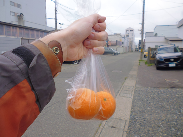
I make it to the (naturally trilingual) coach stop with time to spare…

…which should be a good thing, for only as other passengers arrive do I realize that – unlike in New Zealand – I apparently need to get a label for my luggage, so I rush inside the station and pick one up for each of my two backpacks. In the end, it turns out I only would have needed one for the big one that I checked into the cargo hold, but oh well.

As I wait I get to witness the Japanese infrastructure department at peak efficiency: A team of workers with a pair of trucks arrives and closes off a path of the road to renew the markings.

And by the time the coach arrives and I get in…

…they are already almost done.

Since I have chosen to take the coach, my route back south to Sapporo should be distinctively different than the train trip to the north. Most notably, the coach does not take a route through the mountains, but rather along the western coast via the scenic route 232 all the way to Rumoi (留萌 “Detained Sprout”) before turning inlands towards the expressways for the second half of the journey.

So, this is actually my first coach ride in Japan. As opposed to New Zealand where you would pretty much ride everywhere by coach, it has been train rides all the way for me here in Japan, up until now. This trip should take me some distance through the landscape of the Souya Peninsula, then to the coast, and finally up the expressway which would take us first to the valley of Asahikawa, and finally back to Sapporo.
One thing that is definitely worth of note is how spacious the seats in the coach are: Unlike all other coaches I have taken thus far, this one has only three seats per row, with every single one having a generous amount of space.

Although it technically qualifies as a nonstop ride, there are still two rest stops along the way, which together make up the third base of my Hokkaido Homerun. The first is the Sunset Plaza of Haboro (羽幌 “Feather Canopy”)…

…and the second being a rest stop along the Hokkaido Expressway near Sunagawa, this one being particularly noteworthy due to having a sacred stone and… whatever the hell that is.

The Sunagawa rest stop is also particularly noteworthy for having a nice little park segment, where the cicadas are quite vocal around this time of the year. Eventually, I even manage to catch one of the little buggers in the act.
So now I'm back in Sapporo, one of the big Japanese cities with all its oddities, such as obscure traffic sign holders.

And that means, now it’s high time to look at…
The Road Ahead
After having been sustaining myself in Japan by means of remote work for my software development Job for back in Germany for almost four months, I have now finally found a place to stay with the locals by means of HelpX. A family living in the outskirts of Sapporo has agreed to take me in, and theirs is my next destination. Now I only have to find a way to get there, which is not an easy task with Sapporo’s ineffably horrible public transport system. My little odyssey starts with a trek through the Sapporo Oodori Chika 500m Bijutsukan (札幌大通地下ギャラリー500m美術館 “Sapporo Oodori Underground Gallery 500m Art Museum”), which apparently is also a fitness walking track of sorts…

…and then once again with the Tozai Line to Shin-Sapporo-Eki, where I wait for my host to pick me up.

Since this is my first HelpX experience in Japan I am naturally a little bit nervous, but in the end, it all works out. My host arrives at the station to pick me up with a stylish orange minivan, and takes me to what should be my home for the next month: A nice house in the suburbs of Sapporo.

With this, my Homerun is completed, and I settle into a nice if somewhat sparsely furnished room, happy to finally get a break from constantly travelling and staying in one place for some time.

I look forward to the work that awaits me in this place, and to finally living together with a Japanese family. How should this turn out for me? Find out, in the next chapter of the Travelling Fox Blog!
No comments:
Post a Comment